
Breezy Saturday with rain showers at times; rain/snow mix this evening
Northern Minnesota could see an afternoon mix, then snow Saturday night
Go Deeper.
Create an account or log in to save stories.
Like this?
Thanks for liking this story! We have added it to a list of your favorite stories.


We had highs in the 70s last weekend, but this weekend’s temps will be much more typical of November.
Our average Twin Cities high temperature is 42 degrees on Nov. 14. Most spots in the metro area will top out in the upper 30s to around 40 this Saturday.
Much of Minnesota will have Saturday highs in the 30s, with some lower 40s in far southern Minnesota plus parts of western Wisconsin. A few spots in far western Minnesota may also touch 40. It’ll be breezy, with gusts over 25 mph at times.
Rain and snow chances
Turn Up Your Support
MPR News helps you turn down the noise and build shared understanding. Turn up your support for this public resource and keep trusted journalism accessible to all.
Rain showers are expected to spread across roughly the southern half of Minnesota plus west-central Wisconsin as we go through Saturday afternoon. The best chance of rain in the metro area should hold off until after 2 p.m. or so. A rain/snow mix is possible this afternoon in northern Minnesota and northwestern Wisconsin. That mix transitions to light snow this evening. The areas with afternoon rain showers (including the metro) could see a changeover to a rain/snow mix this evening then all snow later tonight. Only a coating of snow is expected in the metro area tonight, with 1 to 2 inches of snow possible Saturday evening/overnight in parts of northeastern Minnesota and northwestern Wisconsin:
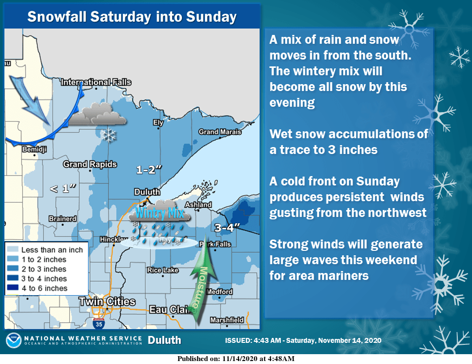
A few snow showers are possible Sunday morning in northern Minnesota, with a flurry chance elsewhere.
The National Oceanic and Atmospheric Administration’s North American Mesoscale (NAM) forecast model shows the potential precipitation pattern Saturday evening through Sunday afternoon:
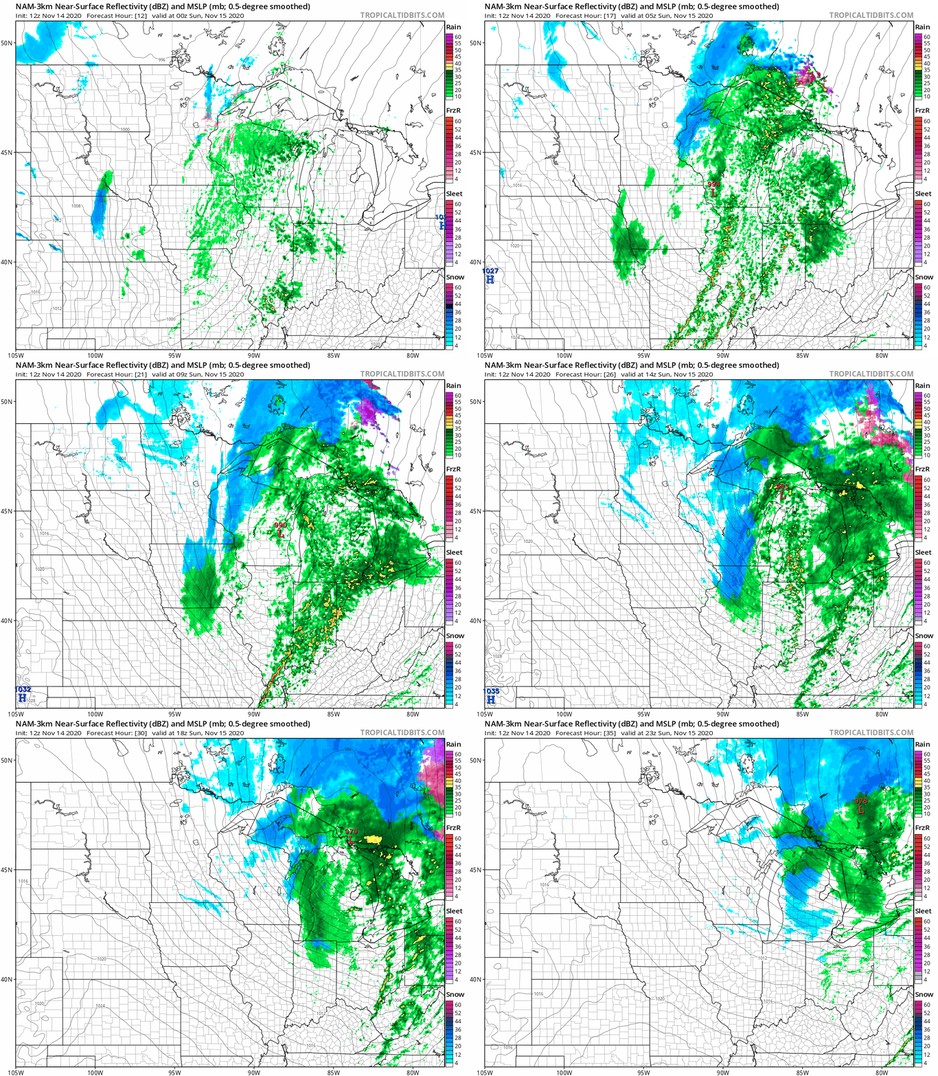
You can hear updated weather information on the MPR network, and you’ll see updated weather info on the MPR News live weather blog.
Chilly and blustery on Sunday
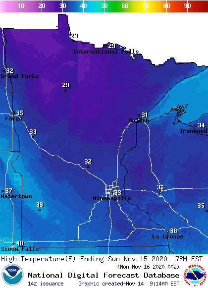
Sunday highs will only reach the 30s in most areas, with 20s to the northwest:
Sunday wind gusts are expected to be in the 25-35 mph range:
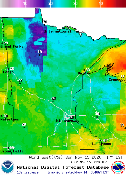
Plotted values are in knots, with 26 knots equal to 30 mph.
Gusts could be over 40 mph over Lake Superior, where there’s a gale watch for Sunday:
URGENT - MARINE WEATHER MESSAGE National Weather Service Marquette MI 1039 AM EST Sat Nov 14 2020 LSZ162-263-142345- /O.CON.KMQT.GL.A.0024.201115T1600Z-201116T0700Z/ Lake Superior west of a line from Saxon Harbor WI to Grand Portage MN beyond 5NM- Lake Superior from Saxon Harbor WI to Upper Entrance to Portage Canal MI 5NM off shore to the US/Canadian border including Isle Royale National Park- 1039 AM EST Sat Nov 14 2020 /939 AM CST Sat Nov 14 2020/ ...GALE WATCH REMAINS IN EFFECT FROM SUNDAY MORNING THROUGH LATE SUNDAY NIGHT... * WHAT...West winds 25 to 35 kt with gusts up to 45 kt and waves 6 to 11 ft possible. * WHERE...Lake Superior west of a line from Saxon Harbor WI to Grand Portage MN beyond 5NM and Lake Superior from Saxon Harbor WI to Upper Entrance to Portage Canal MI 5NM off shore to the US/Canadian border including Isle Royale National Park. * WHEN...From Sunday morning through late Sunday night. * IMPACTS...Strong winds can cause hazardous waves which could capsize or damage vessels and reduce visibility. PRECAUTIONARY/PREPAREDNESS ACTIONS... Mariners should consider altering plans to avoid possible hazardous conditions. Remain in port, seek safe harbor, alter course, and/or secure the vessel for severe wind and waves.
The week ahead
There aren’t any big storms on the weather map for the coming work week. Twin Cities metro area highs are projected to reach 40 on Monday, followed by lower 30s Tuesday then mid to upper 40s Wednesday through Friday.
November snow
Our official Twin Cities snowfall (as measured at MSP airport) is 8.3 inches so far this November. Our long-term average is 9.3 inches for the entire month of November. Of course, we’re less than half-way through this month.
The snowiest November in Twin Cities weather records was in 1991, with 46.9 inches! The biggest daily totals in November 1991 were 18.5 inches on Nov. 1, which was part of the blizzard that began on Halloween, and 12.6 inches on Nov. 29.
An interesting tidbit about the Halloween 1991 blizzard is that all that snow (28.4 inches from Oct. 31 to early on Nov. 3) melted in less than three weeks. The official Twin Cities snow depth was down to 15 inches by Nov. 10 and to just a trace by Nov. 20:

The column next to the snow depth column shows new snow, and there wasn’t any measurable snow from Nov. 11 through Nov. 20 of 1991. We had a chance to rest our muscles between the big storms!
Programming note
You can hear my live weather updates on MPR News at 7:35 a.m., 9:35 a.m. and 4:39 p.m. each Saturday and Sunday.

