
Strong Sunday winds; best snow shower chances to the north
Parts of NW Wisc. could see several inches of snow
Go Deeper.
Create an account or log in to save stories.
Like this?
Thanks for liking this story! We have added it to a list of your favorite stories.


There’s plenty of fresh snow in the Duluth area, where 5 inches of snow were tallied between midnight and 6 a.m. Sunday:
Additional weekend snow reports include 8 inches in Carlton, Minn. and around 5 inches a few miles northwest of Two Harbors. You can view snow reports as they are posted by the NWS here.
Sunday snow
Northern Minnesota may see some light snow showers at times Sunday afternoon, with a stray flurry possible in portions of central and southern Minnesota. Several inches of snow are possible in parts of far northwestern Wisconsin, where a winter weather advisory continues into early afternoon:
Turn Up Your Support
MPR News helps you turn down the noise and build shared understanding. Turn up your support for this public resource and keep trusted journalism accessible to all.
You can hear updated weather information on the MPR network, and you’ll see updated weather info on the MPR News live weather blog.
Strong winds
A strong low pressure system to our east will continue to give us strong and gusty winds Sunday afternoon. Here are the forecast peak wind gusts:

There’s a wind advisory for much of Minnesota and parts of Wisconsin through Sunday afternoon:

Here are details of the wind advisory:
URGENT - WEATHER MESSAGE National Weather Service Twin Cities/Chanhassen MN 328 AM CST Sun Nov 15 2020 MNZ060>063-070-078-WIZ023>026-028-151730- /O.CON.KMPX.WI.Y.0014.201115T1200Z-201116T0000Z/ Hennepin-Anoka-Ramsey-Washington-Dakota-Goodhue-St. Croix-Pierce- Dunn-Pepin-Eau Claire- Including the cities of Minneapolis, Blaine, St Paul, Stillwater, Hastings, Red Wing, Hudson, River Falls, Menomonie, Durand, and Eau Claire 328 AM CST Sun Nov 15 2020 ...WIND ADVISORY REMAINS IN EFFECT UNTIL 6 PM CST THIS EVENING... * WHAT...West winds around 25 mph with gusts up to 45 mph expected. * WHERE...Portions of west central Wisconsin and east central and southeast Minnesota. * WHEN...From 6 AM to 6 PM CST Sunday. * IMPACTS...Gusty winds could blow around unsecured objects. Tree limbs could be blown down and a few power outages may result. PRECAUTIONARY/PREPAREDNESS ACTIONS... Use extra caution when driving, especially if operating a high profile vehicle. Secure outdoor objects.
A gale warning for Lake Superior continues until 2 a.m. Monday:

Here are details of the gale warning:
URGENT - MARINE WEATHER MESSAGE National Weather Service Marquette MI 407 AM EST Sun Nov 15 2020 LSZ162-151715- /O.CON.KMQT.GL.W.0053.201115T1600Z-201116T0800Z/ Lake Superior west of a line from Saxon Harbor WI to Grand Portage MN beyond 5NM- 407 AM EST Sun Nov 15 2020 /307 AM CST Sun Nov 15 2020/ ...GALE WARNING REMAINS IN EFFECT FROM 11 AM EST /10 AM CST/ THIS MORNING TO 3 AM EST /2 AM CST/ MONDAY... * WHAT...West winds 20 to 30 kt with gusts up to 40 kt and waves 5 to 8 ft expected. * WHERE...Lake Superior west of a line from Saxon Harbor WI to Grand Portage MN beyond 5NM. * WHEN...From 11 AM EST /10 AM CST/ this morning to 3 AM EST /2 AM CST/ Monday. * IMPACTS...Strong winds will cause hazardous waves which could capsize or damage vessels and reduce visibility. PRECAUTIONARY/PREPAREDNESS ACTIONS... Mariners should alter plans to avoid these hazardous conditions. Remain in port, seek safe harbor, alter course, and/or secure the vessel for severe conditions.
Temperature trends
Nearly steady to slowly falling temps are expected Sunday afternoon. The Twin Cities high that will go into the books for today is likely to be our 3 a.m. Sunday reading of 36 degrees at MSP airport. Afternoon highs in the metro area will be mainly in the lower 30s.
Monday highs will range from the upper 20s in far northern Minnesota to the upper 40s in far southern Minnesota:
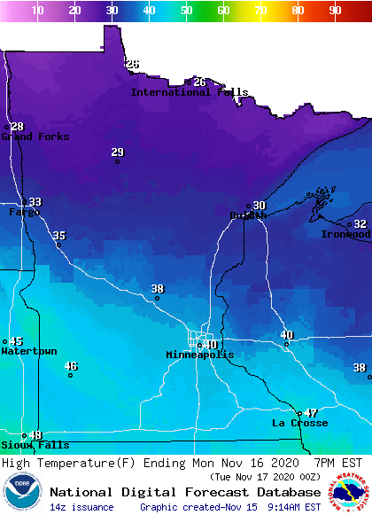
Some spots in the metro area could creep slightly above 40.
Monday wind gusts will be in the 15-20 mph range for many areas, with gusts over 30 mph possible in southwestern Minnesota::
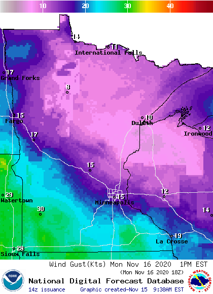
Plotted values are in knots with 15 knots equal to around 17 mph.
Back to temperatures, Twin Cities metro area highs are projected to reach the lower 30s Tuesday, followed by upper 40s Wednesday and Thursday then lower 40s on Friday.
Looking ahead to Thanksgiving week, the NWS Climate Prediction Center shows a tendency for above normal temperatures in Minnesota and western Wisconsin from Nov. 22 through Nov. 29:

We’ll see if that pans out.
Programming note
You can hear my live weather updates on MPR News at 7:35 a.m., 9:35 a.m. and 4:39 p.m. each Saturday and Sunday.

