Bright and cool Monday, with light winds; no weather drama this week

Ohio braces for a winter storm
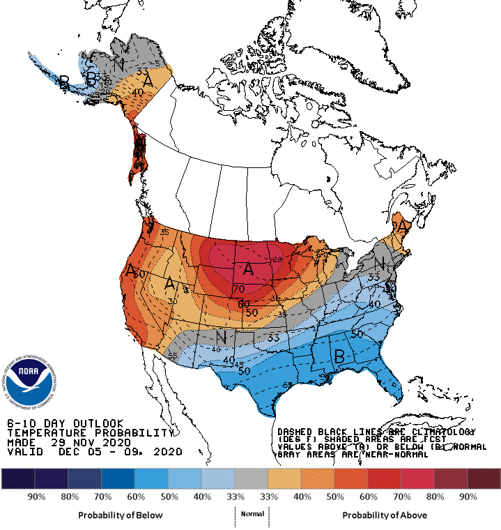
rt1129ext2
Temperature outlook Dec. 5 through Dec. 9
NWS Climate Prediction Center

The highest wind gust at Minneapolis-St. Paul International Airport on Sunday was 44 mph. It was a bad hair day for many of us that ventured out without a hat or cap.

A high pressure system will move closer during the overnight hours, then park nearby on Monday. As a result, our winds will be much lighter on Monday, gusting to only around 10 mph in many spots:

rt1130g2
Monday noon forecast wind gusts
National Weather Service

Plotted values are in knots, with 8 knots equal to about 9 mph. It’ll be a bit breezy in far northwestern Minnesota Monday afternoon.

Monday highs will range from the mid 20s in northeastern Minnesota to the mid 30s in southwestern Minnesota:

Create a More Connected Minnesota

MPR News is your trusted resource for the news you need. With your support, MPR News brings accessible, courageous journalism and authentic conversation to everyone - free of paywalls and barriers. Your gift makes a difference.

rt1130h2
Monday forecast highs
National Weather Service

We could top out around 30 degrees in the metro area. Our average Twin Cities high temp is 33 degrees this time of year.

Quiet week for us

Computer models aren’t showing any big storms in Minnesota or western Wisconsin this coming week.

The National Oceanic and Atmospheric Administration’s Global Forecast System (GFS) model shows this precipitation pattern for the Monday through Friday time frame:

 rt1129rad3
Simulated radar (6-hour intervals) Monday through Friday
NOAA, via Tropicaltidbits.com

Look at it as a loop of simulated regional radar snapshots taken every 6 hours over that time span. A stray flurry cannot be ruled out at some point.

You can hear updated weather information on the MPR network, and you’ll see updated weather info on the MPR News live weather blog.

Storm takes aim at Ohio

Parts of Ohio and northwestern Pennsylvania could get a lot of snow Monday night through Tuesday night.

Here’s the NWS post on that winter storm:

rt1129cleve
Ohio/NW Pennsylvania snow potential
National Weather Service

Cleveland could be among the cities that get 8 inches or more of snow.

Temperature trends

Twin Cities metro area highs are projected to be in the mid 30s Tuesday, followed by upper 30s Wednesday, mid 30s Thursday and upper 30s on Friday.

The 6-10 day temperature outlook (next weekend through the beginning of the following week) from the NWS Climate Prediction Center shows a good chance of above normal temps in Minnesota and western Wisconsin:

rt1129ext2
Temperature outlook Dec. 5 through Dec. 9
NWS Climate Prediction Center

Our average Twin Cities high temps are in the lower 30s this time of year, so even mid to upper 30s and lower 40s would be warmer than our average highs.

Programming note

You can hear my live weather updates on MPR News at 7:35 a.m., 9:35 a.m. and 4:39 p.m. each Saturday and Sunday.