
A murky Monday; warmer temps midweek, then a rain/snow chance Friday
Some spots could hit the 50s on Wednesday
Go Deeper.
Create an account or log in to save stories.
Like this?
Thanks for liking this story! We have added it to a list of your favorite stories.


Dense fog blanketed parts of western Minnesota Sunday morning. Portions of western Minnesota and a small section of central Minnesota will see areas of dense fog Sunday night into Monday morning.
Dense fog advisories run from 11 p.m. this Sunday to 11 a.m. Monday in the grey-shaded areas on this map:
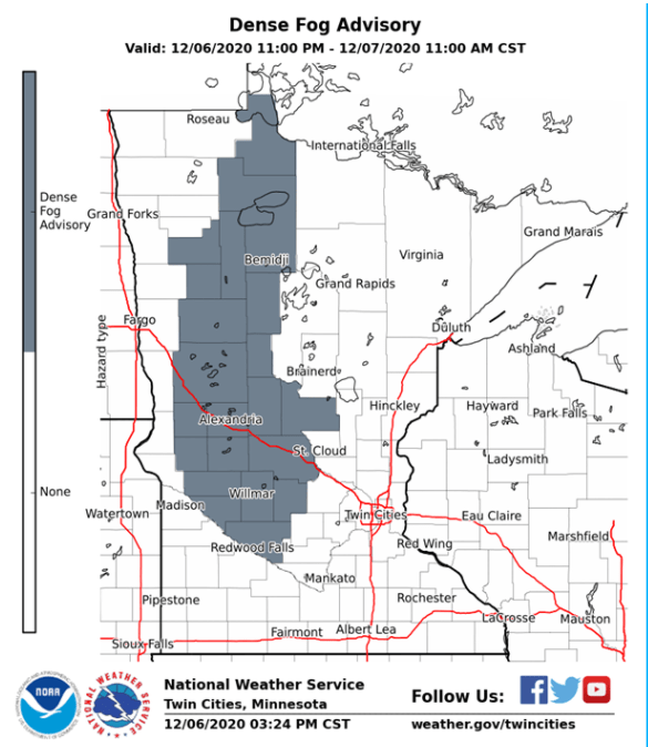
Here are details of the portion of the advisory that includes St. Cloud:
URGENT - WEATHER MESSAGE National Weather Service Twin Cities/Chanhassen MN 216 PM CST Sun Dec 6 2020 MNZ041>043-047>049-055>058-065-070430- /O.NEW.KMPX.FG.Y.0010.201207T0500Z-201207T1700Z/ Douglas-Todd-Morrison-Stevens-Pope-Stearns-Swift-Chippewa- Kandiyohi-Meeker-Renville- Including the cities of Alexandria, Long Prairie, Little Falls, Morris, Glenwood, St Cloud, Benson, Montevideo, Willmar, Litchfield, and Olivia 216 PM CST Sun Dec 6 2020 ...DENSE FOG ADVISORY IN EFFECT FROM 11 PM THIS EVENING TO 11 AM CST MONDAY... * WHAT...Visibility one quarter mile or less in dense fog. * WHERE...Portions of central and west central Minnesota. * WHEN...From 11 PM this evening to 11 AM CST Monday. * IMPACTS...Hazardous driving conditions due to low visibility. * ADDITIONAL DETAILS...As temperatures fall below freezing, some icy patches on roadways will become possible, especially on bridges. PRECAUTIONARY/PREPAREDNESS ACTIONS... If driving, slow down, use your headlights, and leave plenty of distance ahead of you.
There could be some patchy fog and freezing fog in the Twin Cities metro area late Sunday night and Monday morning.
Turn Up Your Support
MPR News helps you turn down the noise and build shared understanding. Turn up your support for this public resource and keep trusted journalism accessible to all.
You can hear updated weather information on the MPR network, and you’ll see updated weather info on the MPR News live weather blog.
Any sun on Monday?
The short answer for most of Minnesota is “no”.
Parts of far western Minnesota may see some clearing Monday afternoon. Here’s NOAA’s North American Mesoscale (NAM) forecast model’s depiction of cloud cover Monday afternoon:
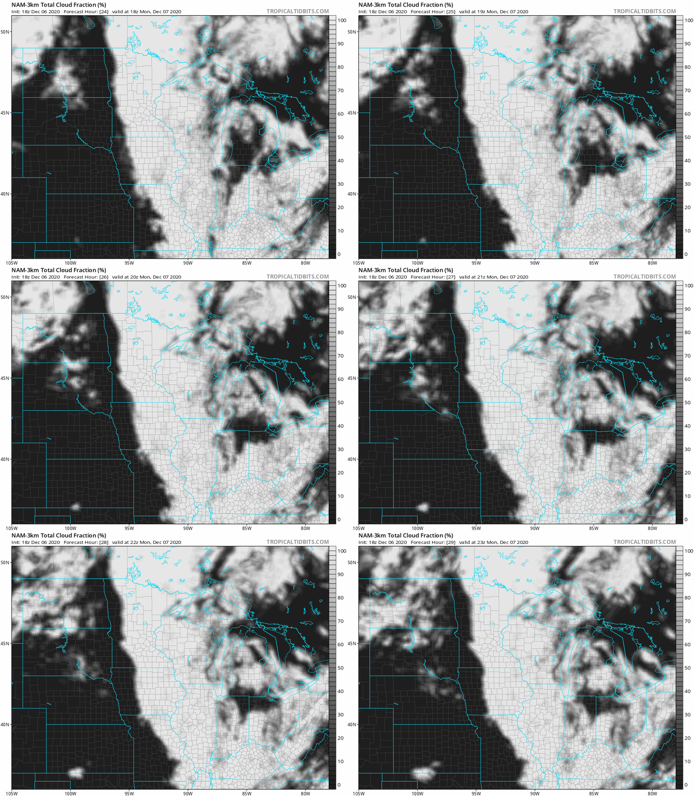
The NAM model shows clouds blanketing eastern Minnesota and western Wisconsin throughout Monday.
Monday temps and winds
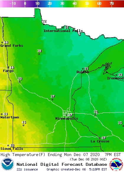
Most areas will have Monday afternoon highs in the 30s, with some 40s in southwestern Minnesota and parts of west-central Minnesota:
Winds will be light in most areas, but they could gust to 12-16 mph in far western Minnesota by Monday afternoon:
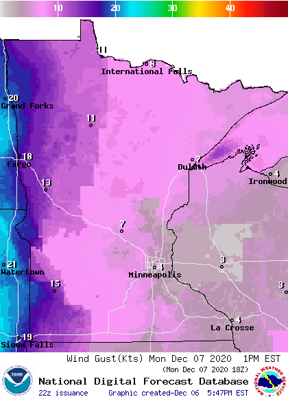
Plotted values are in knots, with 7 knots equal to about 8 mph and 13 knots equal to 15 mph.
Temperature trends
Twin Cities metro area highs are projected to reach the mid 40s Tuesday and around 50 on Wednesday. We could top out in the mid 40s on Thursday, followed by upper 30s Friday.
By the way, parts of southwestern Minnesota could reach the upper 50s Wednesday afternoon.
Rain and snow chances Friday?
Forecast models haven’t reached agreement on our rain/snow chances Friday and Saturday.
Here’s the Sunday afternoon run of the National Oceanic and Atmospheric Administration’s Global Forecast System (GFS) model, showing the potential precipitation pattern from Friday morning through Saturday evening:
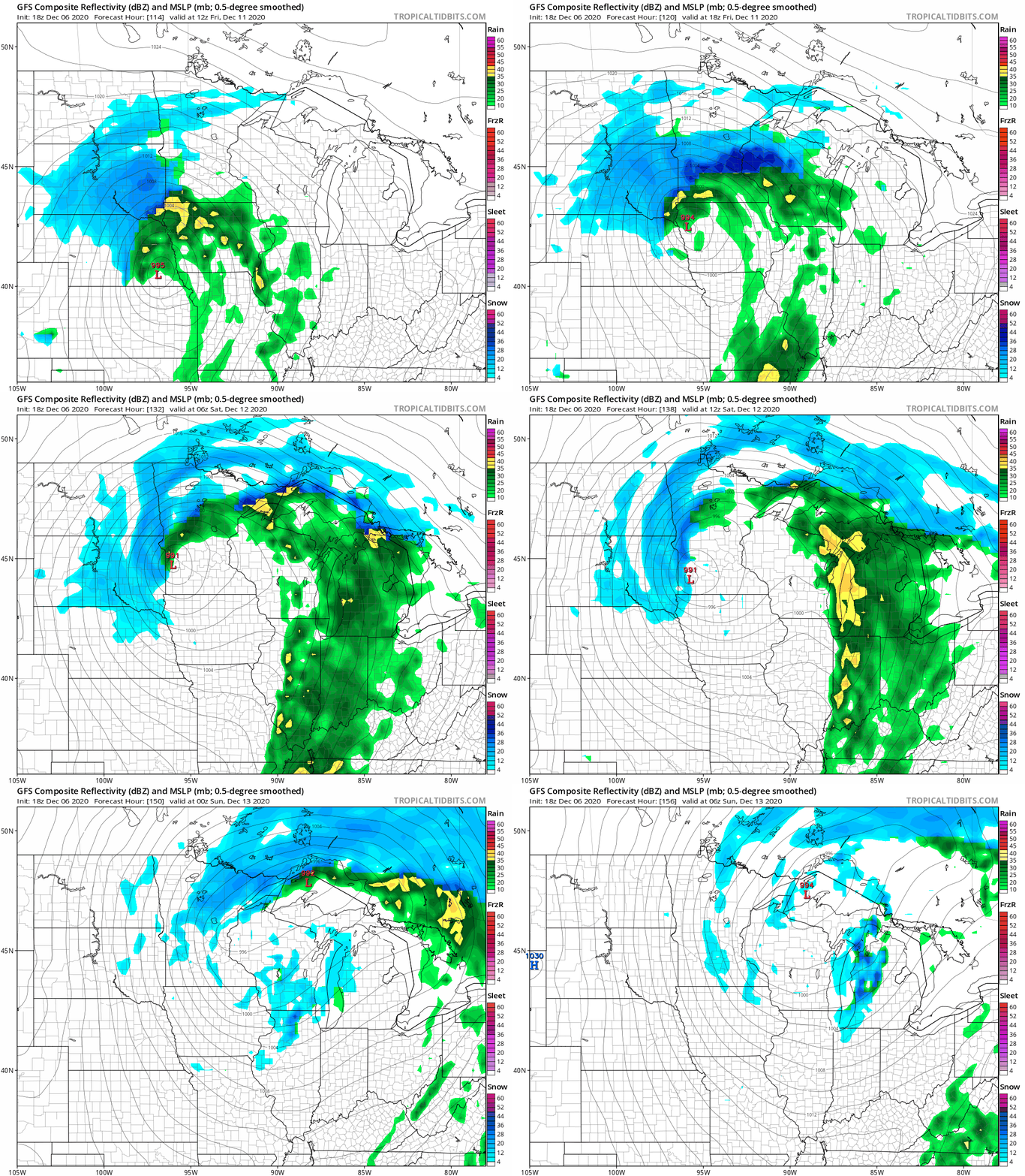
This track would give the Twin Cities metro area a mix of rain and snow early on Friday, then mainly rain until the system pulls away on Saturday. Western and northern Minnesota would see the highest snow amounts in that scenario. Some other forecast models keep the accumulating snow in mainly northern Minnesota.
Bottom line, it’s way too early to forecast who will get accumulating snow this Friday or Saturday. Check forecast updates as we get closer to Friday.
Programming note
You can hear my live weather updates on MPR News at 7:35 a.m., 9:35 a.m. and 4:39 p.m. each Saturday and Sunday.

