
Seasonable cold returns by the weekend
The recent pattern of limited snow continues
Go Deeper.
Create an account or log in to save stories.
Like this?
Thanks for liking this story! We have added it to a list of your favorite stories.


Clouds increase and temperatures fall as we head toward the weekend. Meanwhile, snow chances stay sparse.
Thursday’s forecast
Thursday morning began mild following a very warm Wednesday where highs in the 40s and 50s put most of the state at least 20 degrees above average. A few spots dipped into the 20s, but the majority of Minnesota started Thursday in the 30s.
In northern Minnesota, a wintry mix of precipitation moved in late Wednesday. As of Thursday morning, the precipitation is mostly snow with occasional rain mixed in.

There are some slick spots on the roads, so drive with care.
Turn Up Your Support
MPR News helps you turn down the noise and build shared understanding. Turn up your support for this public resource and keep trusted journalism accessible to all.
The wet weather moves out through the morning, but thanks to low pressure and a weak front moving across the state, clouds remain and spread south through the day.
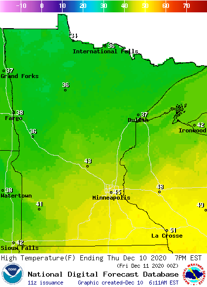
Due to the cloudier skies, temperatures will not be as warm as Wednesday, with highs in the 30s north. Because southern Minnesota starts off with sun, highs will be in the 40s, and there could be a couple of isolated 50s depending on the exact timing of the clouds.
Extended forecast
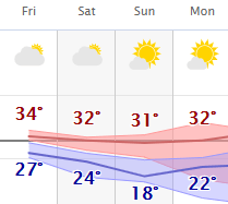
Behind the cold front that moves through Minnesota Thursday, northerly winds drop temperatures closer to seasonable levels by Friday. For perspective, the average high for Dec. 10 is 29 degrees in the Twin Cities and 21 in International Falls.
So, highs in the 20s north and 30s south through the weekend are actually still slightly above average, despite being noticeably colder than the recent trend.
Here is that forecast for the Twin Cities:
A potent storm we’ve been monitoring all week is still forecast to pass southeast of the state Friday into Saturday, but it likely only clips southeastern Minnesota with light snow on Saturday.
However, that system does keep skies mostly cloudy Friday and Saturday, with more sunshine returning Sunday.
It currently looks like the pattern of near to slightly above temperatures continues most of next week, and precipitation chances stay spotty. This means the lack of significant snow much of Minnesota has seen since mid-November is likely to continue.
Programming note
You can hear my live weather updates on Minnesota Public Radio at 7:48 a.m. Monday through Friday morning.

