
From the coldest air of the season back to mild by midweek
Only minimal snow chances through the week
Go Deeper.
Create an account or log in to save stories.
Like this?
Thanks for liking this story! We have added it to a list of your favorite stories.


The same cold front that brought snow Sunday is now making Monday the coldest day so far this fall, but temperatures rebound quickly.
Although light, with most of Minnesota seeing under an inch of snow, the snow that fell Sunday was the most parts of the state have seen in a while.
Duluth saw 0.9 inches, while the 0.4 in the Twin Cities was the highest amount in over three weeks, since a half-inch on Nov. 22.
Behind that system, much colder air moved across the state.
Turn Up Your Support
MPR News helps you turn down the noise and build shared understanding. Turn up your support for this public resource and keep trusted journalism accessible to all.
Monday’s forecast
That chilly air brought the coldest morning of the season to much of Minnesota, with northern Minnesota below zero, most of the state in the single digits and a corridor from the Twin Cities toward Rochester clinging in the low double-digits.
Despite mostly sunny skies, highs will be similarly cold, ranging from single digits north, to 20s south.
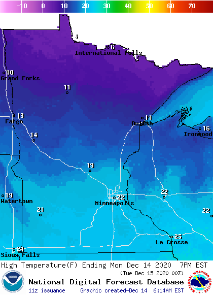
This puts the state 5 to 15 degrees below average, which would not normally be uncommon, but this season has been so mild, those highs will also be the coldest of the season for many places.
For example, the Twin Cities’ previous coldest high temperature so far this fall occurred Sunday at 27 degrees. Even International Falls, which is currently 12 degrees above average for the month of December, has had highs in the 20s or above all season, with the coldest high so far this past Saturday at 22.
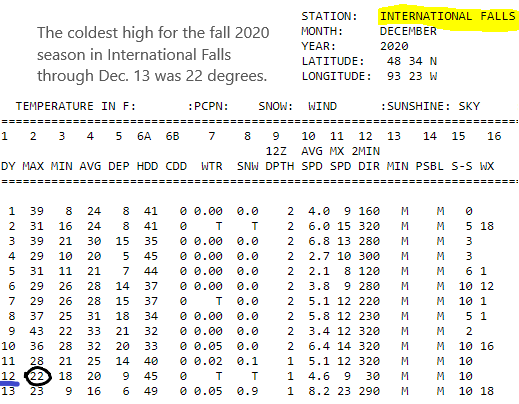
So, even though Monday’s forecast high of 6 in International Falls is not unusual (the average high for Dec. 14 is 19 degrees), it is frigid compared to the mild weather that has marked most of our fall.
Temperatures rise again
Already by Tuesday, high temperatures return to average, ranging from the upper teens north to the upper 20s south.
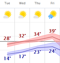
Then we warm back above average by Wednesday and stay mild the rest of the week, with highs predominantly in the 20s north and 30s south. Here is that forecast for the Twin Cities:
Light snow chances
Overall, precipitation remains limited, but there are a couple chances for snow through the week.
On Tuesday, a weather disturbance brings the entire state mostly cloudy skies, along with spotty snow in northern Minnesota. Accumulation is expected to remain under an inch, and a few flurries could make their way into the southern half of the state.
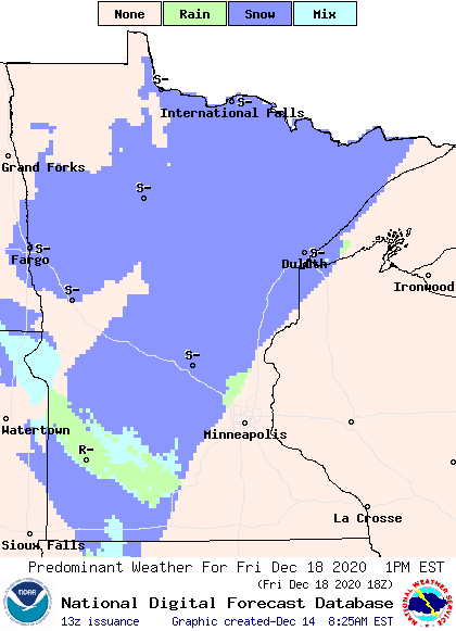
Then a cold front moves through on Friday, bringing light precipitation chances with it. While northern Minnesota likely sees another dusting of snow with that system, southern Minnesota may be mild enough to get a mix of light rain or sprinkles along with a few snowflakes.
Programming note
You can hear my live weather updates on Minnesota Public Radio at 7:48 a.m. Monday through Friday morning.

