
A couple rounds of light snow in the forecast
Statewide temperatures turn mild again through most of next week
Go Deeper.
Create an account or log in to save stories.
Like this?
Thanks for liking this story! We have added it to a list of your favorite stories.


Temperatures shift from seasonable cold back to above average, making it less likely for upcoming snow to stick.
Monday was only a few degrees below average, but Minnesota has been so mild through most of November and December, that was enough for much of the state to have its coldest day so far this fall.
For the Twin Cities, both the high of 21 and low of 10 were the coldest this season, but they were barely below the averages of 27 and 12, so Monday’s cold was not uncommon for this time of year. What is unusual is that we have not seen more cold days like that.
Tuesday’s forecast
After Monday’s below average cold, Tuesday started off seasonably chilly, with morning temperatures predominantly in the single digits to low teens.
Turn Up Your Support
MPR News helps you turn down the noise and build shared understanding. Turn up your support for this public resource and keep trusted journalism accessible to all.
Highs will also be typical for mid-December with teens north and 20s south.

Skies remain mostly cloudy through the day, and a disturbance is bringing very light snow that moves across northern Minnesota through the day.
Most places will see less than an inch of accumulation, although the very eastern edge of the Arrowhead could see a couple inches of snow.

Southern Minnesota may see a couple isolated flurries during the day.
Limited precipitation
There are currently no major storms in the forecast for the next week, but there are a few chances for light rain or snow.
After Tuesday’s light snow, northern and central Minnesota could see another dusting Wednesday night into early Thursday.
A more widespread precipitation chance comes Friday, associated with a cold front.
It currently looks like most of the state can expect less than an inch of snow, but southern Minnesota is likely to be so mild that some of the precipitation will be a rain-snow mix, reducing snow totals even more.
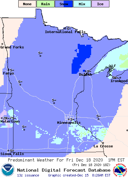
Mild weather prevails
Besides the limited precipitation, mild weather will keep southern Minnesota struggling to keep any snow cover.
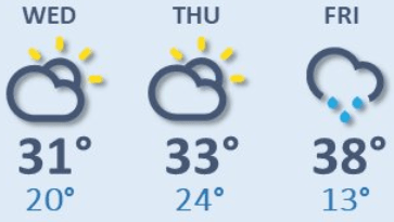
On Wednesday, temperatures stay near to slightly above average. Then the entire state turns mild for December by Thursday, with highs in the 20s and 30s.
Friday will be about 10 degrees above average, and a couple 40s are even possible in southern Minnesota.
Here is that forecast trend for the Twin Cities:
The mild weather continues into next week, putting most of the highs for the southern Minnesota above freezing.
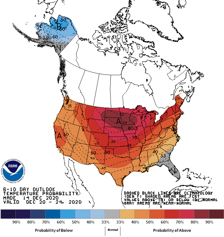
With only light snow chances, those temperatures will make it hard to keep any snow cover on the ground for the southern half of the state as we head toward Christmas.
Programming note
You can hear my live weather updates on Minnesota Public Radio at 7:48 a.m. Monday through Friday morning.

