
Weekend forecast: no real weather drama; flirting with 40 on Sunday
Northern Minnesota has a flake chance Sunday p.m.
Go Deeper.
Create an account or log in to save stories.
Like this?
Thanks for liking this story! We have added it to a list of your favorite stories.


Do you have snow envy? While many Minnesotans are looking at bare ground right now, residents of New England area are dealing with heavy snow:
Snow continues this afternoon/early evening in parts of New England. The National Oceanic and Atmospheric Administration’s North American Mesoscale (NAM) forecast model shows the potential precipitation pattern this Thursday afternoon and evening:

Our weekend
We aren’t expecting any significant snow in Minnesota this weekend. Northern Minnesota may see some light snow showers late Sunday.
Our average Twin Cities high temperature is 26 degrees on Dec. 19. The metro area will probably top out in the upper 20s this Saturday. Much of Minnesota will see Saturday highs in the 20s, with some lower 30s from far southern Minnesota into west-central and southwestern Wisconsin:
Turn Up Your Support
MPR News helps you turn down the noise and build shared understanding. Turn up your support for this public resource and keep trusted journalism accessible to all.

Saturday winds gusts will be 10 mph or less in most areas, but gusts may range from 16-25 mph in northwestern Minnesota by afternoon::
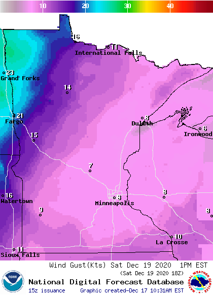
Plotted values are in knots, with 8 knots (equal to around 9 mph) and 20 knots (about 23 mph).
Back to temperatures, Sunday highs will flirt with 40 degrees in the Twin Cities metro area. There will be a lot of highs in the 30s in northern and central Minnesota, with 40s in the far south:

Sunday afternoon wind gusts are expected to be in the 10-16 mph range in most areas.
Programming note
You can hear my live weather updates on MPR News at 7:35 a.m., 9:35 a.m. and 4:39 p.m. each Saturday and Sunday.

