
Snow north, mix south Sunday evening into early Monday; colder midweek
Cloud cover during Saturn/Jupiter conjunction Monday?
Go Deeper.
Create an account or log in to save stories.
Like this?
Thanks for liking this story! We have added it to a list of your favorite stories.


Looking for snow? Here’s the latest info:
Snow was falling in parts of northwestern Minnesota early Sunday evening. Snow is expected to spread across much of northern and central Minnesota and parts of western Wisconsin Sunday evening and overnight Sunday night. The Twin Cities metro area will probably see some periods of light rain showers and snow showers in that same time period. Snow may linger in parts of northeastern Minnesota and western Wisconsin on Monday.
The National Oceanic and Atmospheric Administration’s North American Mesoscale (NAM) forecast model shows the potential precipitation pattern Sunday evening through Monday afternoon:
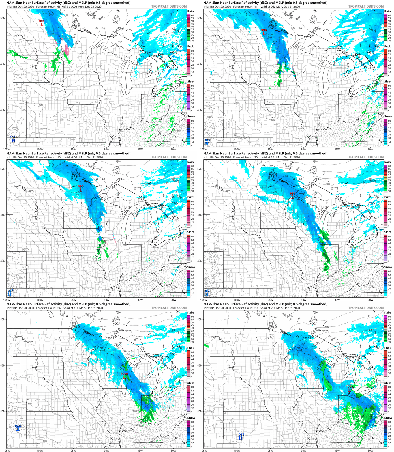
Snow is shaded blue in the forecast loop, with rain shaded green and a mix shaded pink.
Turn Up Your Support
MPR News helps you turn down the noise and build shared understanding. Turn up your support for this public resource and keep trusted journalism accessible to all.
Snow amounts in the 2-3 inch range are possible Sunday evening into Monday in parts of northern Minnesota, including International Falls, Duluth and Bemidji:
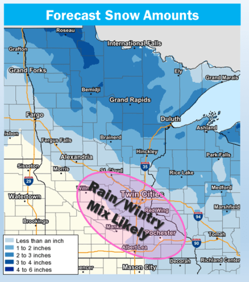
Brainerd and Hinckley could see 1-2 inches of snow, with less than one inch in St. Cloud and most of the Twin Cities metro area. Due to the mix of rain and snow, some spots in the metro area may only see a light coating to one-half inch or so of snow.
You can hear updated weather information on the MPR network, and you’ll see updated weather info on the MPR News live weather blog.
Monday temps and winds
Monday highs will be in the 30s in most areas, with 20s in far northern Minnesota:
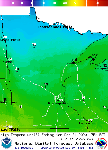
A few spots in southwestern Minnesota may top 40.
It’ll be windy on Monday with gusts of 25-35 mph in many areas:
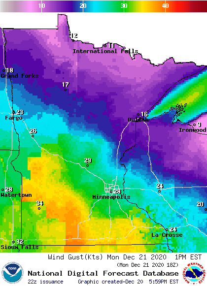
Plotted wind gusts are in knots, with 28 knots equal to around 32 mph. Parts of southwestern and south-central Minnesota could see wind gusts over 40 mph at times.
Monday conjunction of Jupiter and Saturn
Jupiter and Saturn will appear very close to each other Monday evening. Here’s a description of the event, from Sky & Telescope:
While we're all trying our best to keep our distance from one another during the current pandemic, Jupiter and Saturn are defiantly doing exactly the opposite. Since September they've been drawing closer and closer as they inch toward their Great Conjunction on Monday, December 21st. That night the gas giants will shine shoulder to shoulder just 0.1° apart (1/5th the apparent diameter of the full Moon) in their closest conjunction since July 1623.
Every 20 years, Jupiter, the closer and faster planet, laps slower Saturn and the two pair up briefly in a Great Conjunction. The last occurred on May 31, 2000, when they stood 1.2° apart low in the solar glare at dawn.
Here are viewing tips from NASA:
For those who would like to see this phenomenon for themselves, here’s what to do:
Find a spot with an unobstructed view of the sky, such as a field or park. Jupiter and Saturn are bright, so they can be seen even from most cities.
An hour after sunset, look to the southwestern sky. Jupiter will look like a bright star and be easily visible. Saturn will be slightly fainter and will appear slightly above and to the left of Jupiter until December 21, when Jupiter will overtake it and they will reverse positions in the sky.
The planets can be seen with the unaided eye, but if you have binoculars or a small telescope, you may be able to see Jupiter’s four large moons orbiting the giant planet.
Will you be able to see the conjunction? Here’s the cloud forecast for 5 p.m. Monday, using NOAA’s NAM forecast model:
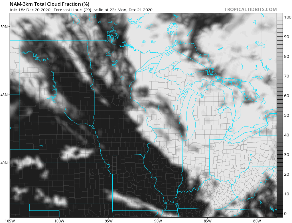
Northeastern Minnesota and much of Wisconsin look very cloudy at that time, with patchy clouds and breaks in the cloud cover elsewhere. The cloud forecast may change, so check for forecast updates on Monday.
Temperature trends
Much colder air will move in toward midweek. Twin Cities metro area highs will be around 40 degrees on Tuesday. We could see early morning temps in the lower 30s on Wednesday, with temps falling through the 20s as we go through the rest of the day. Metro area highs only reach the middle teens on Thursday, followed by lower 20s on Christmas Day.
Snow chances?
In addition to the Monday snow chance for some areas that we already talked about, there is another snow chance this week.
Some forecast models show snow for northern and central Minnesota plus northwestern Wisconsin Tuesday night into Wednesday. A few models include the Twin Cities metro area in that accumulating snow, but several forecast models keep the metro area dry Tuesday night and Wednesday. We’ll have more details on that tomorrow. Thursday and Friday look dry.
Programming note
You can hear my live weather updates on MPR News at 7:35 a.m., 9:35 a.m. and 4:39 p.m. each Saturday and Sunday.

