
Extreme cold Thursday, then milder on Christmas Day
Dry skies expected through Saturday, with snow possible again Sunday
Go Deeper.
Create an account or log in to save stories.
Like this?
Thanks for liking this story! We have added it to a list of your favorite stories.


In the wake of Wednesday’s crippling snowstorm, dangerous cold has spread across the state. However, temperatures rebound by Christmas Day and stay seasonable through the holiday weekend.
Minnesota took a major weather hit Wednesday, with both high winds and heavy snow, the combination of which caused blizzard conditions in parts of the state. Although a couple northern locations like Ely and Cloquet also saw 6 inches of snow, the brunt of the snow hit the Twin Cities metro and surrounding locations, with numerous reports ranging from 5 to 9 inches.
Meanwhile, the highest wind report was 70 mph in Grand Marais, but various parts of the state saw gusts over 50 and 60 mph.
As all of this was happening, temperatures tumbled, bringing in dangerous cold.
Turn Up Your Support
MPR News helps you turn down the noise and build shared understanding. Turn up your support for this public resource and keep trusted journalism accessible to all.
Thursday’s weather
That arctic air behind Wednesday’s storm dropped the entire state below zero Thursday morning.
Winds have diminished some from the extreme high winds the state saw Wednesday, but there are still many parts of Minnesota seeing gusts over 20 and 30 mph Thursday morning.

This combination of cold and wind is putting morning wind chills at 20 to 40 below zero. This is dangerous enough cold that almost the entire state is under a wind chill advisory until noon.
Even under sunshine and dry skies through the day, temperatures rise little, with most of the state just below zero, and a few spots barely making it above zero in southern Minnesota.
Although the winds keep diminishing, it will still stay breezy through the day, so even during the “warmth” of the afternoon, wind chills will still feel like minus 10 to minus 20.

Holiday weekend forecast
Under clear skies Thursday night, temperatures Friday start even lower than Thursday morning, with the entire state well below zero.
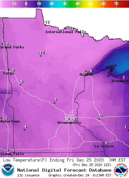
However, because winds will not be as gusty, the wind chill will be less extreme than Thursday morning, with wind chills “only” in the negative teens and 20s Friday morning.
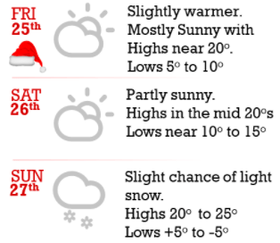
Under sunny skies, highs Christmas Day rebound into the teens north and 20s south, which is near average.
Temperatures then remain seasonable through the rest of the holiday weekend, with teens and occasion single-digit highs north and 20s south. Most of the weekend also stays dry, although it currently looks like light snow moves across the state Sunday, which could bring one to two inches of snow north and a dusting south.
Here is that forecast for the Twin Cities:
We’ll keep you updated through the weekend if any travel concerns are expected with that snow potential. Have a wonderful holiday!
Programming note
You can hear my live weather updates on Minnesota Public Radio at 7:48 a.m. Monday through Friday morning.

