
A few flurries pass through Minnesota Monday
Temperatures start mild for late December, but highs stay below average
Go Deeper.
Create an account or log in to save stories.
Like this?
Thanks for liking this story! We have added it to a list of your favorite stories.


Cloud cover and cooler air keep temperatures from warming much Monday, while a light dusting of snow moves across the state.
Monday’s forecast
Temperatures Monday are starting off slightly above average, with most of the state ranging from the single digits to low teens.
Behind a cold front that moved through Sunday and with another minor disturbance moving across Minnesota Monday, temperatures do not warm much, putting the afternoon slightly cooler than Sunday. Highs will vary from the single digits north to lower 20s south.
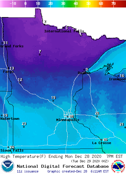
This is about 10 degrees below average north, but only slightly below average south.
Turn Up Your Support
MPR News helps you turn down the noise and build shared understanding. Turn up your support for this public resource and keep trusted journalism accessible to all.
The minor disturbance passing through the state is bringing light snow, predominantly flurries, across Minnesota. As of 7 a.m., there is a corridor of snow from about Detroit Lakes to Duluth. It is so light, much of it is not even being picked up by radar. The snow continues south, including possibly bringing flurries to the Twin Cities from late morning into early afternoon.
No significant accumulation is expected.
That disturbance also keeps a few more clouds across the state Monday, but there will also be some sunshine mixed in.
A much more potent snowstorm targets Minnesota again Tuesday.
That extended forecast will be updated by 9 a.m.
Programming note
You can hear my live weather updates on Minnesota Public Radio at 7:48 a.m. Monday through Friday morning.

