
Light snow persists in northern Minnesota
Temperatures stay steady much of Wednesday
Go Deeper.
Create an account or log in to save stories.
Like this?
Thanks for liking this story! We have added it to a list of your favorite stories.


The storm that brought snow across Minnesota has moved out, and the areas of lingering snow wind down through the day.
Wednesday’s forecast
The winter storm that moved south of Minnesota Tuesday, bringing its northern edge of snow into the state has now departed.

Snow ended for all but northern Minnesota overnight, and the lingering light snow north will end from west to east through the morning, with the Arrowhead seeing snow end in the afternoon. Most places can expect under an inch of additional snow.
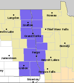
Thanks to the improving conditions, the winter weather advisories have ended for all of Minnesota except right along the North Dakota border, where the advisories continue until 9 a.m. due to a blowing snow concern in open areas.
Turn Up Your Support
MPR News helps you turn down the noise and build shared understanding. Turn up your support for this public resource and keep trusted journalism accessible to all.
Because of the cloud over and a mild wind flow much of the overnight, temperatures stayed predominantly steady.
That means morning temperatures are well above average in the teens and 20s Wednesday morning. However, now under a breezy west to northwest wind flow (slightly cooler) and continued cloud cover through the day, temperatures also change little by afternoon.
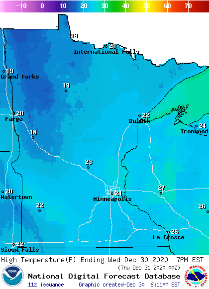
Clouds finally start clearing later in the day, which could bring a few breaks of sunshine by the afternoon.
Above average temperatures return by next week and snow chances appear limited.
That extended forecast will be updated around 9 a.m.
Programming note
You can hear my live weather updates on Minnesota Public Radio at 7:48 a.m. Monday through Friday morning.

