
Weekend forecast: A lot of clouds; temps a bit above normal
Dense fog advisory central Minnesota through Friday morning
Go Deeper.
Create an account or log in to save stories.
Like this?
Thanks for liking this story! We have added it to a list of your favorite stories.


I’ll get to the weekend forecast shortly.
Areas of dense fog have developed in central Minnesota. A dense fog advisory is in effect from today through 11 a.m. Friday for much of central and west-central Minnesota:
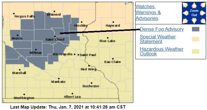
The dense fog advisory does not include the 7-county Twin Cities metro area, but it includes bordering counties to the west and northwest.
Here are details of the dense fog advisory:
Turn Up Your Support
MPR News helps you turn down the noise and build shared understanding. Turn up your support for this public resource and keep trusted journalism accessible to all.
URGENT - WEATHER MESSAGE National Weather Service Twin Cities/Chanhassen MN 1014 AM CST Thu Jan 7 2021 MNZ041>045-047>052-054>059-064>066-080015- /O.NEW.KMPX.FG.Y.0006.210107T1614Z-210108T1700Z/ Douglas-Todd-Morrison-Mille Lacs-Kanabec-Stevens-Pope-Stearns- Benton-Sherburne-Isanti-Lac Qui Parle-Swift-Chippewa-Kandiyohi- Meeker-Wright-Yellow Medicine-Renville-McLeod- Including the cities of Alexandria, Long Prairie, Little Falls, Princeton, Mora, Morris, Glenwood, St Cloud, Sauk Rapids, Elk River, Cambridge, Madison, Benson, Montevideo, Willmar, Litchfield, Monticello, Granite Falls, Olivia, and Hutchinson 1014 AM CST Thu Jan 7 2021 ...DENSE FOG ADVISORY IN EFFECT UNTIL 11 AM CST FRIDAY... * WHAT...Visibility one quarter mile or less in dense fog. * WHERE...Portions of central, east central and west central Minnesota. * WHEN...Until 11 AM CST Friday. * IMPACTS...Hazardous driving conditions due to low visibility. * ADDITIONAL DETAILS...Slick spots on roads, overpasses, and sidewalks are also possible as the fog freezes on exposed surfaces. PRECAUTIONARY/PREPAREDNESS ACTIONS... If driving, slow down, use your headlights, and leave plenty of distance ahead of you.
You can hear updated weather information for Minnesota and western Wisconsin on the MPR network, and you’ll see updated weather info on the MPR News live weather blog.
The weekend
Clouds will linger through much of the coming weekend, with areas of fog most prominent at night and during the morning hours. One forecast model does show that we may see a glimpse of sun Sunday afternoon.
Our average Twin Cities high temperature is 23 degrees on Jan. 9. The metro area will top out in the mid to upper 20s Saturday afternoon, with highs in the 20s across Minnesota and western Wisconsin:
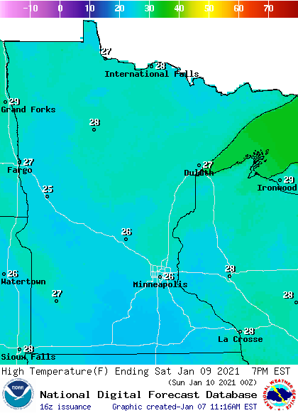
Winds will be light on Saturday.
Sunday highs will also be in the 20s, with upper 20s in the metro area:
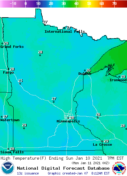
Light winds will linger through Sunday.
Forecast models aren’t showing any accumulating snow this weekend.
Programming note
You can hear my live weather updates on MPR News at 7:35 a.m., 9:35 a.m. and 4:39 p.m. each Saturday and Sunday.

