
Weekend forecast: Saturday clouds; skies may brighten Sunday afternoon
Warmer than normal temps
Go Deeper.
Create an account or log in to save stories.
Like this?
Thanks for liking this story! We have added it to a list of your favorite stories.


Visibilities have improved across much of Minnesota this Friday, but a dense fog advisory continues until 2 p.m. today in portions of northern Minnesota:
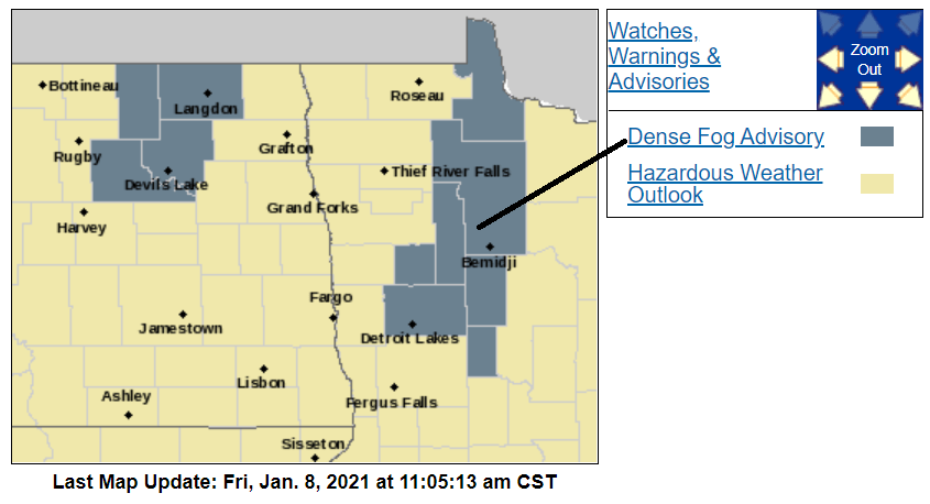
Here are details of the dense fog advisory:
URGENT - WEATHER MESSAGE National Weather Service Grand Forks ND 1103 AM CST Fri Jan 8 2021 MNZ006-009-016-017-022>024-027-028-082000- /O.EXP.KFGF.FG.Y.0003.000000T0000Z-210108T1700Z/ /O.NEW.KFGF.FG.Y.0005.210108T1703Z-210108T2000Z/ Lake Of The Woods-North Beltrami-North Clearwater-South Beltrami- Mahnomen-South Clearwater-Hubbard-West Becker-East Becker- Including the cities of Baudette, Red Lake, Redby, Ponemah, Bagley, Clearbrook, Bemidji, Mahnomen, Naytahwaush, Waubun, Alida, Ebro, Lake Itasca, Long Lost Lake, Lower Rice Lake, Roy Lake, Upper Rice Lake, Park Rapids, Detroit Lakes, and Wolf Lake 1103 AM CST Fri Jan 8 2021 ...DENSE FOG ADVISORY IN EFFECT UNTIL 2 PM CST THIS AFTERNOON... * WHAT...Visibility less than one quarter mile in dense fog. * WHERE...Lake Of The Woods, North Beltrami, North Clearwater, South Beltrami, Mahnomen, South Clearwater, Hubbard, West Becker and East Becker Counties. * WHEN...Until 2 PM CST this afternoon. * IMPACTS...Hazardous driving conditions due to low visibility. PRECAUTIONARY/PREPAREDNESS ACTIONS... If driving, slow down, use your headlights, and leave plenty of distance ahead of you.
You can hear updated weather information for Minnesota and western Wisconsin on the MPR network, and you’ll see updated weather info on the MPR News live weather blog.
Turn Up Your Support
MPR News helps you turn down the noise and build shared understanding. Turn up your support for this public resource and keep trusted journalism accessible to all.
The weekend
Clouds are expected to linger across most of Minnesota and western Wisconsin on Saturday, with areas of dense fog most prominent overnight Friday night and during the morning hours of Saturday. Forecast models are now showing some breaks in our cloud cover Sunday afternoon. Forecast models aren’t showing any accumulating snow this weekend.
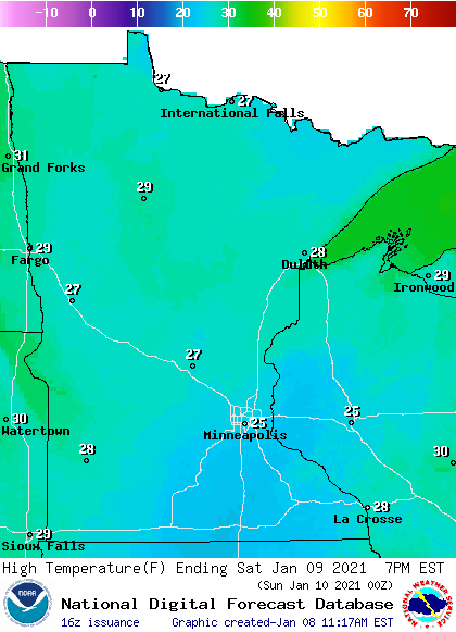
Our average Twin Cities high temperature is 23 degrees on Jan. 9. The metro area will top out in the mid to upper 20s Saturday afternoon, with highs in the 20s across most of Minnesota and western Wisconsin:
Winds will be light on Saturday.
Sunday highs will be in the 20s across most of Minnesota and western Wisconsin:
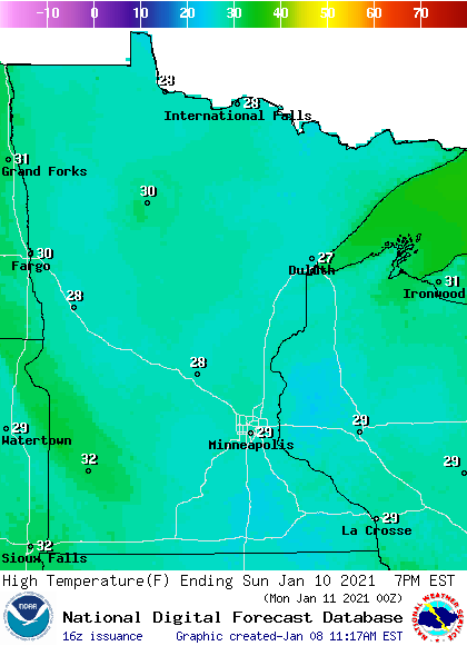
Some spots in the Twin Cities metro area could touch 30 degrees. Parts of northwestern Minnesota and southwestern Minnesota could reach the lower 30s.
Sunday afternoon wind gusts will be less than 10 mph in most of southern Minnesota, with gusts of 11 to 18 mph in the north:
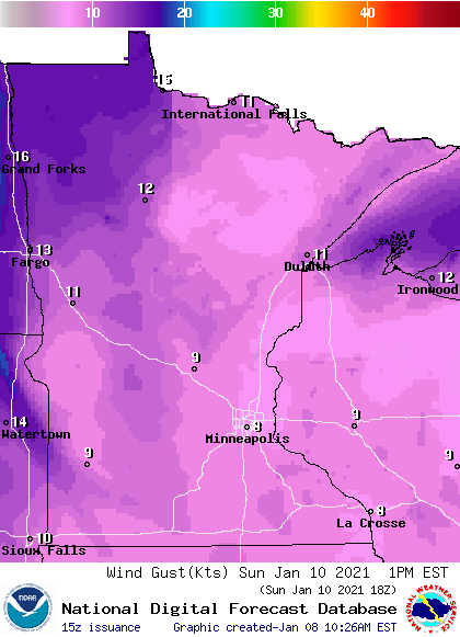
Plotted values are in knots, with 8 knots equal to 9 mph and 12 knots equal to 14 mph.
Snow cover
The Thursday snow depth map from the Minnesota State Climatology Office shows at least 4 inches of snow cover in most locations, with 8 inches or more in northeastern Minnesota and parts of north-central Minnesota:

Parts of northeastern Minnesota have more than 12 inches of snow on the ground. Portions of southwestern Minnesota have very little snow cover.
Programming note
You can hear my live weather updates on MPR News at 7:35 a.m., 9:35 a.m. and 4:39 p.m. each Saturday and Sunday.

