
Pesky clouds and areas of fog today; could hit 30 on Sunday
Dense fog advisories in some areas Saturday morning
Go Deeper.
Create an account or log in to save stories.
Like this?
Thanks for liking this story! We have added it to a list of your favorite stories.


There have been some areas of dense fog this morning in parts of Minnesota.
Dense fog advisories continue until noon in northwestern and central Minnesota. A dense fog advisory runs until 11 a.m. across much of southern Minnesota and most of the Twin Cities metro area, plus three counties of west-central Wisconsin. Carver and Scott counties in the southwestern part of the metro area have a dense fog advisory until noon today.
Here are graphics showing the Saturday morning dense fog advisories:


Here are details of the dense fog advisory that runs until noon in the southwest metro:
Turn Up Your Support
MPR News helps you turn down the noise and build shared understanding. Turn up your support for this public resource and keep trusted journalism accessible to all.
URGENT - WEATHER MESSAGE National Weather Service Twin Cities/Chanhassen MN 919 AM CST Sat Jan 9 2021 MNZ041>045-047>059-064>069-073>077-082>085-091-091800- /O.EXT.KMPX.FG.Y.0007.000000T0000Z-210109T1800Z/ Douglas-Todd-Morrison-Mille Lacs-Kanabec-Stevens-Pope-Stearns- Benton-Sherburne-Isanti-Chisago-Lac Qui Parle-Swift-Chippewa- Kandiyohi-Meeker-Wright-Yellow Medicine-Renville-McLeod-Sibley- Carver-Scott-Redwood-Brown-Nicollet-Le Sueur-Rice-Watonwan- Blue Earth-Waseca-Steele-Martin- Including the cities of Alexandria, Long Prairie, Little Falls, Princeton, Mora, Morris, Glenwood, St Cloud, Sauk Rapids, Elk River, Cambridge, Center City, Madison, Benson, Montevideo, Willmar, Litchfield, Monticello, Granite Falls, Olivia, Hutchinson, Gaylord, Chanhassen, Chaska, Victoria, Shakopee, Redwood Falls, New Ulm, St Peter, Le Sueur, Faribault, St James, Mankato, Waseca, Owatonna, and Fairmont 919 AM CST Sat Jan 9 2021 ...DENSE FOG ADVISORY NOW IN EFFECT UNTIL NOON CST TODAY... * WHAT...Visibility one quarter mile or less in dense fog. * WHERE...Portions of central, east central, south central, southwest and west central Minnesota. * WHEN...Until noon CST today. * IMPACTS...Hazardous driving conditions due to low visibility. * ADDITIONAL DETAILS...Slick spots on roads, overpasses, and sidewalks are also possible as the fog freezes on exposed surfaces. PRECAUTIONARY/PREPAREDNESS ACTIONS... If driving, slow down, use your headlights, and leave plenty of distance ahead of you.
Some areas could see freezing fog at times, and possibly a stray flurry.
You can hear updated weather information for Minnesota and western Wisconsin on the MPR network, and you’ll see updated weather info on the MPR News live weather blog.
Weekend temps and winds
Saturday highs will be mainly in the 20s in Minnesota and western Wisconsin, but a few spots in the northwestern corner of Minnesota could touch 30. Saturday winds will be light in most areas.
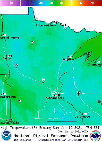
Sunday highs reach the upper 20s to around 30 in most of Minnesota and western Wisconsin:
Sunday afternoon wind gusts will be in the 10-16 mph range in most areas, with higher gusts to the northwest:
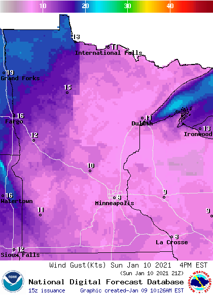
Plotted winds are in knots, with 10 knots equal to 11.5 mph.
Any Sunday sun?
Forecast models are showing plenty of cloud cover in most areas on Sunday. Here’s the Sunday cloud forecast from NOAA’s North American Mesoscale (NAM) forecast model:
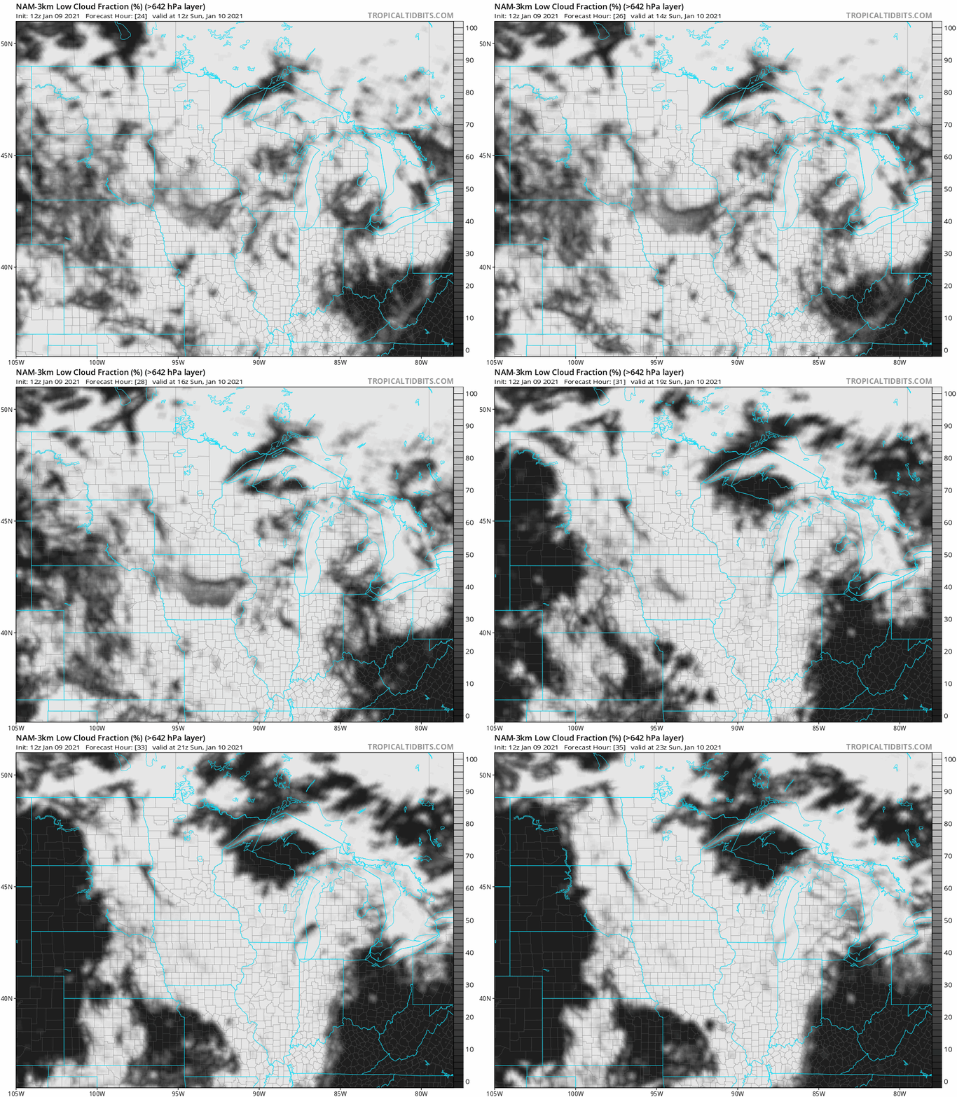
Some thinning or brief breaks are possible in the cloudiest areas Sunday afternoon, but most areas are expected to see a mostly cloudy Sunday. I know, we could use some sun!
Snow cover
Thinking of playing in the snow this weekend? The Thursday snow depth map from the Minnesota State Climatology Office shows at least 4 inches of snow cover in most locations, with 8 inches or more in northeastern Minnesota and parts of north-central Minnesota:

The week ahead
Mild (for January) temps are expected this coming week. Twin Cities metro area highs are projected to reach the mid 30s on Monday, followed by upper 30s Tuesday and Wednesday, then mid 30s Thursday and upper 20s on Friday.
No big storms are expected, but the metro area could see a rain shower or snow shower Wednesday night or early on Thursday.
Programming note
You can hear my live weather updates on MPR News at 7:35 a.m., 9:35 a.m. and 4:39 p.m. each Saturday and Sunday.

