
Temperature whiplash: From 30s to the coldest weather so far this January
Based on averages, Minnesota has passed the coldest time of the year
Go Deeper.
Create an account or log in to save stories.
Like this?
Thanks for liking this story! We have added it to a list of your favorite stories.


Temperatures do quick turns from chilly to mild and cold again through Saturday. Snow stays limited, with more accumulation anticipated over the weekend.
Up through Monday, the majority of Minnesota, including the Twin Cities, had not seen a single day in January with below average temperatures.
There have been a couple times the highs were colder than average, but on those days the lows were so mild, it kept the day as a whole at and often above average. Chillier air Tuesday and again Friday will finally break that trend.
This is despite the fact that we have been in what should have been our coldest time of the year in terms of averages.
We are now rounding the part of winter where our “normal” temperatures slowly rise. For example, the average high for the Twin Cities on Jan. 18 was 23 degrees, and it warms to 24 for Jan. 19.
Turn Up Your Support
MPR News helps you turn down the noise and build shared understanding. Turn up your support for this public resource and keep trusted journalism accessible to all.
Tuesday’s forecast
Compared to Monday, Tuesday morning started off noticeably colder for the majority of the state, especially northern Minnesota.
In northern Minnesota, several places including Hibbing and Bemidji saw their first subzero reading of January, even though typical morning lows should be below zero for northern Minnesota this time of year.
Morning temperatures were much milder south, with southern Minnesota seeing a few 20s Tuesday morning.
With northerly winds and mostly cloudy skies, temperatures warm little through the day, ranging from single digits north to 20s south.

That will also make it the coldest afternoon so far this January for some spots, even though such temperatures normally wouldn’t be uncommon this time of the year.
As mentioned, skies remain mostly cloudy again, and another minor disturbance is bringing light snow and flurries across the state, particularly to the corridor south of Interstate 94.
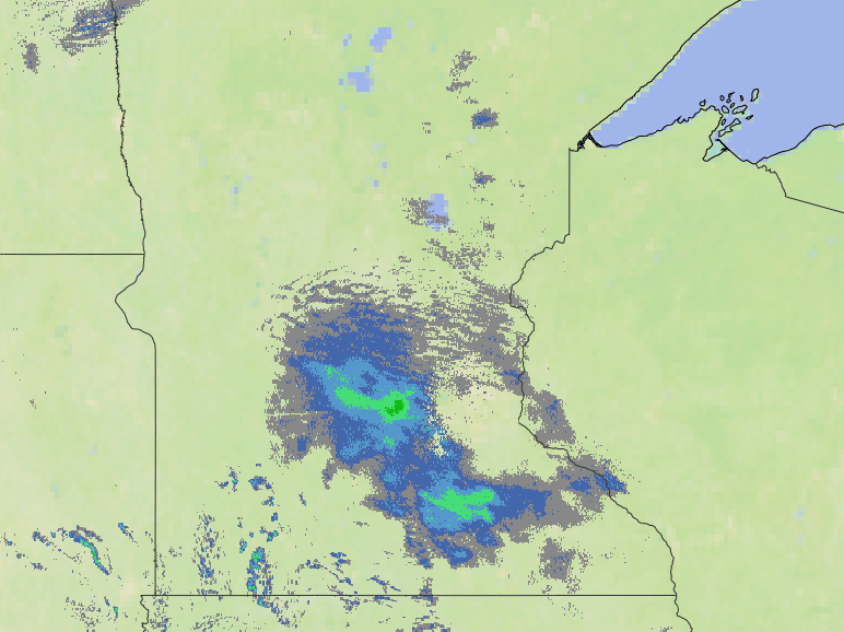
Most places seeing snow will get only a dusting, with isolated amounts up to an inch.
A temperature roller coaster
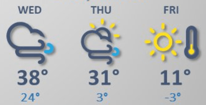
Overnight Tuesday, winds shift to a southerly flow and turn gusty, advecting in warmer air. That sends temperatures rising during the overnight and continuing to warm to mild highs in the 30s Wednesday.
Thursday also stays above average and breezy, but another wind shift by Thursday afternoon draws in colder air again through the day Friday and into Saturday. Friday’s highs will only be in the single digits north and teens south.
Here is that extended forecast for the Twin Cities:
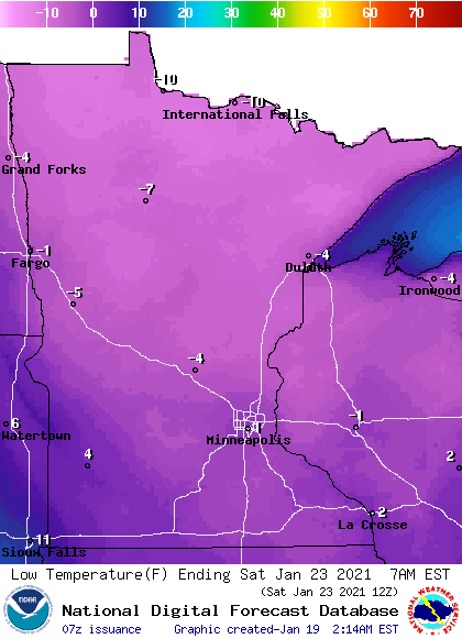
For much of Minnesota, the cold either Friday morning or Saturday morning (varies by location) will take the lead as the coldest morning so far in January.
Weekend snow
Following the snow Tuesday, much of the week stays dry. A snowstorm north of our border will likely clip northern Minnesota with light snow Wednesday.
The best chance for widespread snow comes Saturday into Sunday, although that storm is not forecast to become particularly strong.
Currently, it looks like most of the snow accumulation will be in southern Minnesota and limited to a couple inches.
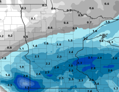
However, this storm is still several days away and could develop more. We will monitor it and keep you updated as it approaches!
Programming note
You can hear my live weather updates on Minnesota Public Radio at 7:48 a.m. Monday through Friday morning.

