
Weekend forecast: Snow chances highest Saturday and early Sunday
Heaviest snow to the south

Go Deeper.
Create an account or log in to save stories.
Like this?
Thanks for liking this story! We have added it to a list of your favorite stories.


The Twin Cities metro area has seen above-normal snowfall so far this snow season.
Here’s the latest summary for the official observation site at Minneapolis-St. Paul International Airport:
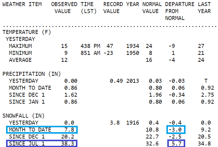
The dark blue boxes highlight our Twin Cities season snowfall, which is 38.3 inches so far, plus the fact that we’re running 5.7 inches above normal for this point in our snow season.
We had a fast start, with our snowiest October in Twin Cities weather records; 9.3 inches. The light blue boxes highlight our Jan. snow total of 7.8 inches, and the fact that we’re running 3 inches below-normal so far this month. We’ll reduce that Jan. “snow deficit” this weekend.
Turn Up Your Support
MPR News helps you turn down the noise and build shared understanding. Turn up your support for this public resource and keep trusted journalism accessible to all.
Weekend snow update
Parts of Nebraska, Iowa, northern Illinois and far southern Wisconsin saw heavy snow earlier this week. Those same areas may see another dumping of snow this weekend.
The National Oceanic and Atmospheric Administration’s North American Mesoscale (NAM) forecast model shows the potential precipitation pattern from Saturday morning through mid-afternoon on Sunday:

Minnesota and west-central Wisconsin would see lighter snow amounts from the NAM storm track, possibly in the one-to- two-inch range. I wouldn’t be surprised to see some three-inch totals in far southern Minnesota. Check forecast updates, since a stronger low pressure system or a storm track that shifts northward would increase our snow amounts in Minnesota and western Wisconsin.
You can hear updated weather information for Minnesota and western Wisconsin on the MPR network, and you’ll see updated weather info on the MPR News live weather blog.
Temperature trends
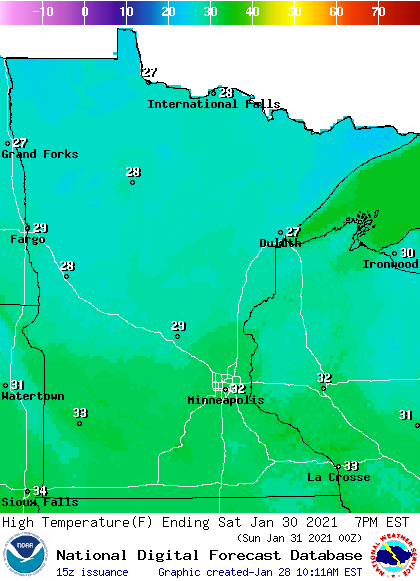
Our average Twin Cities high temperature is 25 degrees on Jan. 30. Metro area highs will probably creep into the lower 30s this Saturday. Southern Minnesota and much of western Wisconsin will also reach the lower 30s, with 20s elsewhere:
Saturday wind gusts are expected to be in the 15-22 mph range in most areas:
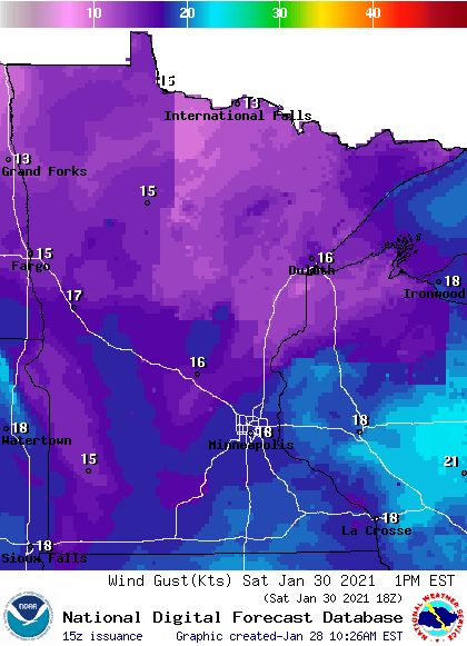
Plotted gusts are in knots, with 18 knots equal to 20.7 mph.
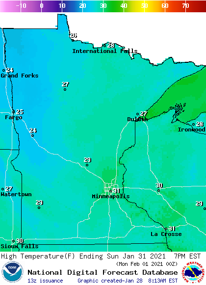
Back to temperatures, Sunday highs will reach the lower 30s in the Twin Cities metro area plus points to the south and east of the metro area, with 20s elsewhere:
Winds will be a bit lighter on Sunday.
Programming note
You can hear my live weather updates on MPR News at 7:35 a.m., 9:35 a.m. and 4:39 p.m. each Saturday and Sunday.

