
Areas of freezing drizzle, then snow, Saturday night; updated snow forecast
Much colder next weekend
Go Deeper.
Create an account or log in to save stories.
Like this?
Thanks for liking this story! We have added it to a list of your favorite stories.


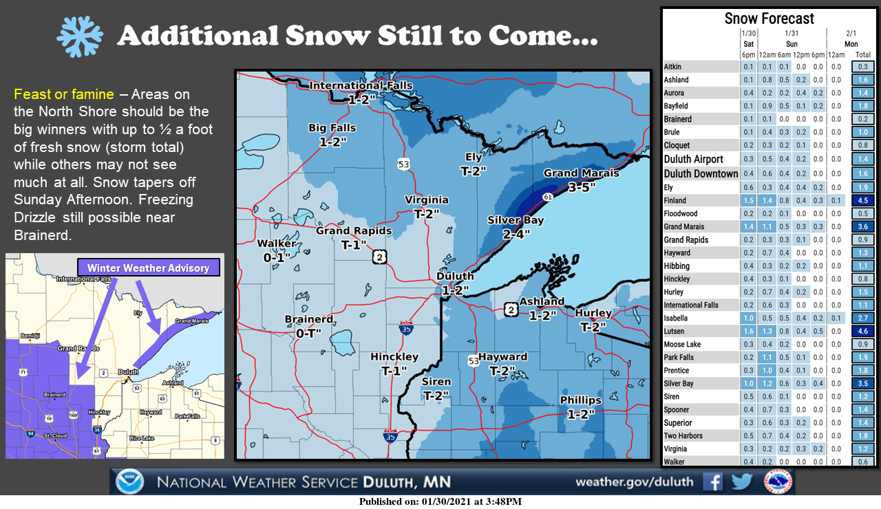
Much of northeastern Minnesota saw snow Saturday afternoon. Two inches of fresh snow were reported in Duluth and there was a four inch report from Two Harbors. Snow continues Saturday evening into Sunday across much of northeastern Minnesota:
Southern and central Minnesota, plus western Wisconsin, will see a mix of drizzle/freezing drizzle and flakes Saturday evening. Some roads and sidewalks will have icy spots. The mix is expected to transition to mainly snow overnight and taper off in most areas Sunday morning.
The National Oceanic and Atmospheric Administration’s High resolution Rapid-Refresh (HRRR) forecast model shows the potential precipitation pattern from Saturday evening through Sunday morning:
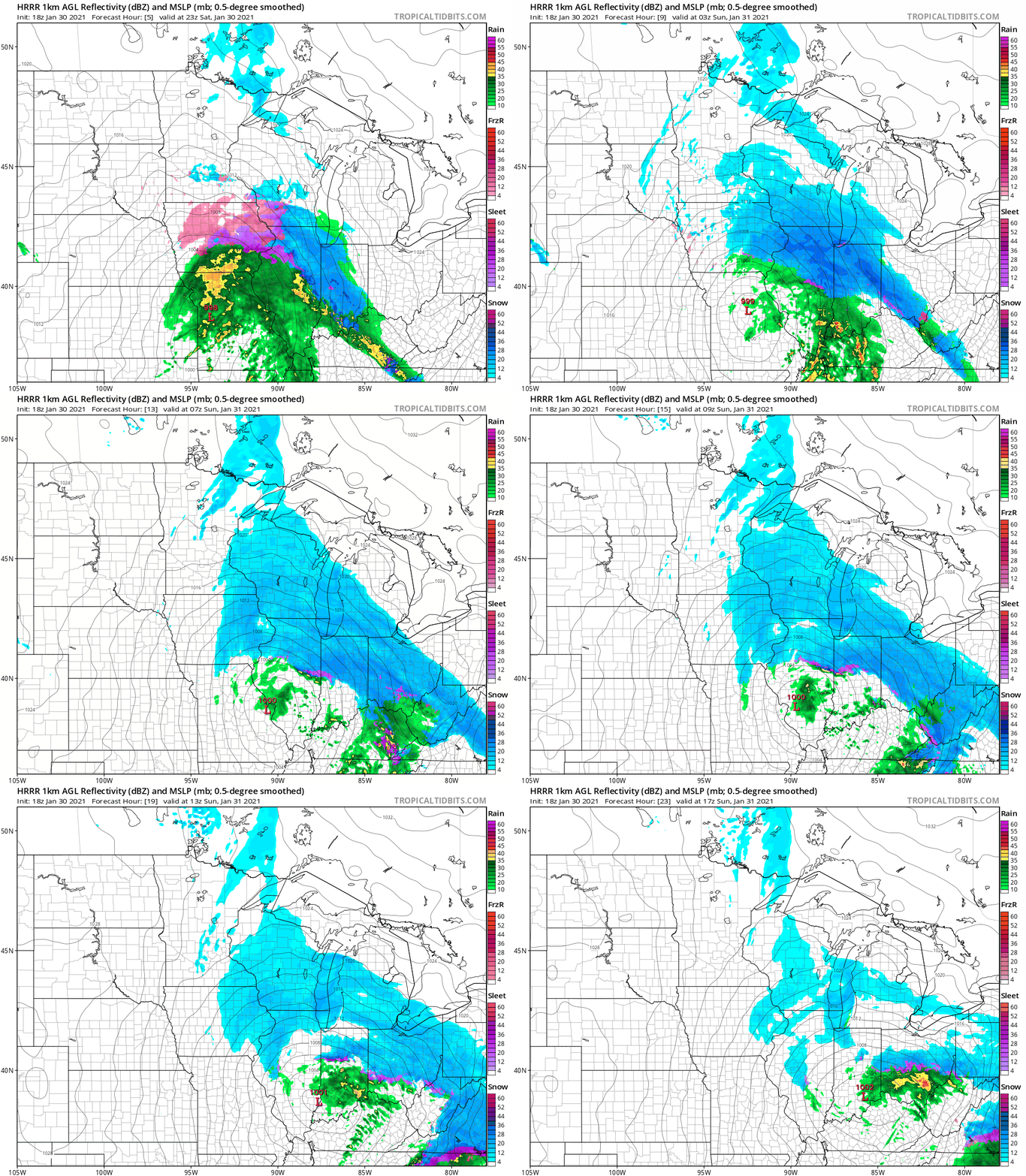
Forecast models don’t depict drizzle and freezing drizzle very well in some cases.
Turn Up Your Support
MPR News helps you turn down the noise and build shared understanding. Turn up your support for this public resource and keep trusted journalism accessible to all.
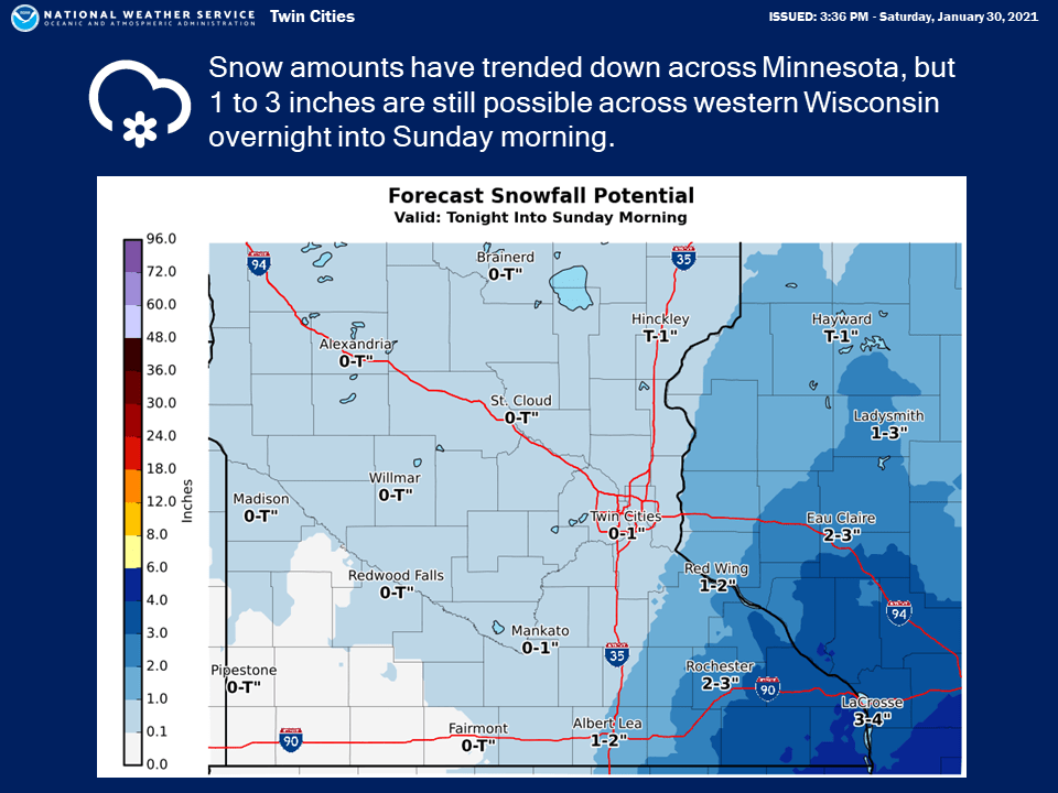
The Twin Cities metro area could see a coating to one inch of snow by Sunday morning. The far southeast metro might see a bit over one inch. 2 to 4 inches of snow are possible overnight through Sunday morning in southeastern Minnesota and parts of western Wisconsin. Here’s the NWS snow forecast:
Advisories
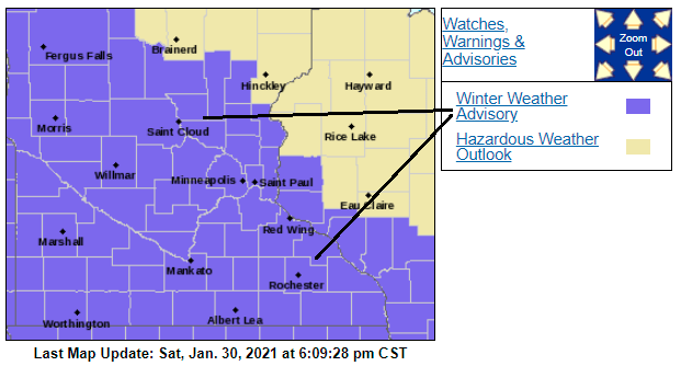
Winter weather advisories cover much of Minnesota and parts of western Wisconsin Saturday night:
Here are details of the winter weather advisory that continues until 6 a.m. Sunday in the Twin Cities metro area:
MNZ052-053-060>062-068-069-076-083-091-092-310500- /O.CON.KMPX.WW.Y.0004.000000T0000Z-210131T1200Z/ Isanti-Chisago-Hennepin-Anoka-Ramsey-Carver-Scott-Le Sueur- Blue Earth-Martin-Faribault- Including the cities of Cambridge, Center City, Minneapolis, Blaine, St Paul, Chanhassen, Chaska, Victoria, Shakopee, Le Sueur, Mankato, Fairmont, and Blue Earth 234 PM CST Sat Jan 30 2021 ...WINTER WEATHER ADVISORY REMAINS IN EFFECT UNTIL 6 AM CST SUNDAY... * WHAT...Freezing precipitation expected, followed by light snow. Total snow accumulations of around 1 inch and ice accumulations of up to a few hundredths of an inch. * WHERE...Portions of east central and south central Minnesota. * WHEN...Until 6 AM CST Sunday. * IMPACTS...Plan on slippery road conditions. PRECAUTIONARY/PREPAREDNESS ACTIONS... Slow down and use caution while traveling. The latest road conditions for the state you are calling from can be obtained by calling 5 1 1. Road conditions can also be found
A winter weather advisory continues until noon Sunday in southeastern Minnesota.
You can hear updated weather information for Minnesota and western Wisconsin on the MPR network, and you’ll see updated weather info on the MPR News live weather blog.
Minnesota road conditions can be found here. Wisconsin road conditions can be found here.
Temperature trends
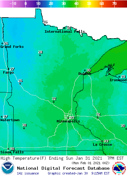
Our average Twin Cities high temperature is 25 degrees on Jan. 31. Metro-area highs will creep into the lower 30s this Sunday. Southern and central Minnesota and much of western Wisconsin could also reach the lower 30s, with mainly 20s in northern Minnesota:
Sunday winds will be fairly light in much of eastern Minnesota and western Wisconsin, with gusts of 11 mph or less:
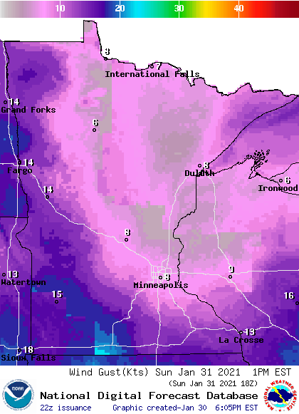
Higher gusts are expected in western Minnesota and far northeastern Minnesota.
Plotted wind gusts are in knots, with 8 knots equal to about 9 mph and 14 knots equal to 16 mph.
Back to temperatures, metro-area highs are projected to be around 30 degrees Monday and Tuesday, followed by mid 30s Wednesday and upper 20s on Thursday. We might only reach the upper teens on Friday.
Colder-than-normal temps are expected next weekend, and the chilly air may linger into the beginning of the following week. The NWS Climate Prediction Center shows a strong tendency for below-normal temps in Minnesota and Wisconsin from Feb. 5 through Feb. 9:
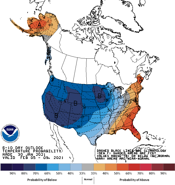
We’ll be sure to let you know if that changes!
Programming note
You can hear my live weather updates on MPR News at 7:35 a.m., 9:35 a.m. and 4:39 p.m. each Saturday and Sunday.

