
February starts mild, then temperatures plummet
January end up well above average for all of Minnesota
Go Deeper.
Create an account or log in to save stories.
Like this?
Thanks for liking this story! We have added it to a list of your favorite stories.


Following a warm January, February starts off mild and quiet, then takes a big turn the second half of the week. A storm Thursday brings both snow chances and the coldest weather parts of Minnesota have seen since December.
January recap
The month of January was a warm one for the entire state, with most places running at least 5 degrees above average and even milder relative to average in northern Minnesota.
For example, the Twin Cities ended January 6.5 degrees above average, while International Falls, on the Canadian border, was 10.6 degrees above.
That put much of central Minnesota in at least the top 10 warmest Januarys on record and most of northern Minnesota in the top five or higher.
The warm month also meant most of the state ended up below average on snow, even where the precipitation amounts were near normal.
Turn Up Your Support
MPR News helps you turn down the noise and build shared understanding. Turn up your support for this public resource and keep trusted journalism accessible to all.
The Twin Cities saw normal January precipitation, but because of the mild temperatures more of it came as rain than usual, so snowfall for the month was only 7.8 inches compared to the average of 12.2.
Monday’s forecast
Thanks to cloudy skies overnight, temperatures remained very mild and the first morning of February started over 10 degrees above average for most of Minnesota. Morning temperatures were predominantly in the 20s, with a few northern locations in the teens.
The northern edge of the state has a minor disturbance moving through, bringing a few flurries Monday morning. Otherwise, skies are expected to remain mostly cloudy, with a few more peaks of sunshine in the afternoon.
Because of the cloud cover, temperatures do not warm much during the day, but highs in the 20s are still mild for early February.

Cold and snow return
Tuesday and Wednesday also stay relatively quiet, with a mix of sunshine and clouds, and temperatures warm even more. By Tuesday, most highs are in the upper 20s or low 30s, and almost all of Minnesota sees 30s Wednesday.
However, by late Wednesday night, a storm that is expected to track south of Minnesota will start bringing in a wintry mix of precipitation.
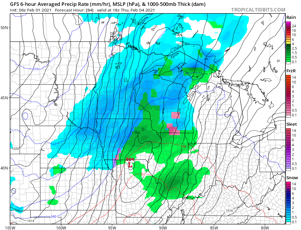
The wintry mix lasts during the overnight because temperatures early Thursday start warm, but gusty winds out of the northwest send temperatures falling through the day.
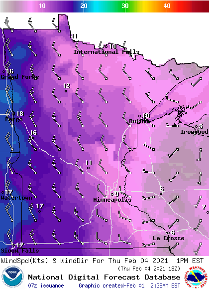
This means the rain should switch predominantly to snow by Thursday morning and stay snow the rest of Thursday before the precipitation moves out late Thursday.
Snow totals are still uncertain given the track of the storm and how much of the initial precipitation starts as rain or freezing rain, but southern Minnesota is likely to see at least a couple inches, with lower totals possible north.
What is much more certain is arctic blast behind the storm.

As colder air continues to filter in, the weekend looks frigid, with highs in the negatives north and single-digits south, and lows below zero for most of the state.
Here is that forecast for the Twin Cities through Friday, showing the start of that cold trend:
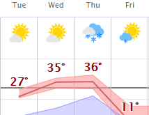
The weekend cold is likely to be the coldest weather parts of southern Minnesota have seen since Christmas and possibly so far this winter.
Programming note
You can hear my live weather updates on Minnesota Public Radio at 7:48 a.m. Monday through Friday morning.

