
Cloudy but mild for Wednesday
Highs run 5 to 15 degrees above average before an arctic blast arrives
Go Deeper.
Create an account or log in to save stories.
Like this?
Thanks for liking this story! We have added it to a list of your favorite stories.


Despite mostly cloudy skies, Wednesday will be the warmest day this week thanks largely to southerly winds ahead of a strong weather system.
Wednesday’s forecast
The state is starting the day Wednesday with breezy winds from the south and southeast that continue through the day.
This warm wind flow already has most of the state seeing morning lows in the upper teens and low 20s, which is a very mild start for early February.
That pattern also warms the state into the upper 20s north and 30s south for highs, and because the milder air keeps funneling in even during the evening hours, some of the highs for Wednesday could be set at the end of the day.
Turn Up Your Support
MPR News helps you turn down the noise and build shared understanding. Turn up your support for this public resource and keep trusted journalism accessible to all.

There are areas of fog again in central and southern Minnesota that linger through the morning, but because of the breezy conditions, visibilities are not as reduced as they were on Tuesday.
Skies stay mostly cloudy, but predominantly dry until late Wednesday when a mix of rain and freezing rain start to move across the state with an approaching winter storm.
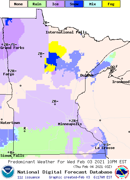
As that storm sends temperatures plunging on Thursday, that mix of precipitation will turn to snow. The extended forecast covering Thursday’s storm and the subsequent arctic air will be updated around 9 a.m.
Programming note
You can hear my live weather updates on Minnesota Public Radio at 7:48 a.m. Monday through Friday morning.

