
Arctic cold lingers Sunday and into the coming week
Flake chance stays south
Go Deeper.
Create an account or log in to save stories.
Like this?
Thanks for liking this story! We have added it to a list of your favorite stories.


You probably don’t need me to tell you this; these temperatures are exceptionally cold.
The highest temp at Minneapolis-St. Paul International Airport during the daylight hours of Saturday was 1 degree above zero. The high that’ll go into the books for today is the 3 degree reading at MSP airport at 12:07 a.m. Saturday. Our average Feb. 6 Twin Cities high is 26 degrees!
Very cold Saturday night and Sunday
Lows late Saturday night and early Sunday are expected to be in the 20s below zero across most of northern and central Minnesota, plus northwestern Wisconsin. Some spots near the Minnesota/Canada border could hit the 30s below zero. Overnight lows in the teens below zero are expected in the Twin Cities metro area, southern Minnesota and west-central Wisconsin.
Turn Up Your Support
MPR News helps you turn down the noise and build shared understanding. Turn up your support for this public resource and keep trusted journalism accessible to all.
Wind chills overnight and Sunday will be coldest to the north. Wind chill warnings continue in northwestern and north-central Minnesota through Saturday night and Sunday, and then on until noon Tuesday. Wind chills there will be in the 40s below zero at times. Here are details, from the NWS:
URGENT - WINTER WEATHER MESSAGE National Weather Service Grand Forks ND 252 PM CST Sat Feb 6 2021 MNZ001-002-004>009-013>017-022-023-NDZ006>008-014>016-024-026>030- 054-091800- /O.CON.KFGF.WC.W.0001.000000T0000Z-210209T1800Z/ West Polk-Norman-Kittson-Roseau-Lake Of The Woods-West Marshall- East Marshall-North Beltrami-Pennington-Red Lake-East Polk- North Clearwater-South Beltrami-Mahnomen-South Clearwater-Towner- Cavalier-Pembina-Benson-Ramsey-Eastern Walsh-Eddy-Nelson- Grand Forks-Griggs-Steele-Traill-Western Walsh- Including the cities of Crookston, East Grand Forks, Ada, Twin Valley, Halstad, Hallock, Karlstad, Lancaster, Roseau, Warroad, Greenbush, Baudette, Warren, Stephen, Argyle, Newfolden, Middle River, Grygla, Red Lake, Redby, Ponemah, Thief River Falls, Red Lake Falls, Fosston, Fertile, McIntosh, Erskine, Bagley, Clearbrook, Bemidji, Mahnomen, Naytahwaush, Waubun, Alida, Ebro, Lake Itasca, Long Lost Lake, Lower Rice Lake, Roy Lake, Upper Rice Lake, Cando, Langdon, Cavalier, Walhalla, Drayton, Pembina, Neche, St. Thomas, Fort Totten, Maddock, Leeds, Minnewaukan, Devils Lake, Grafton, Park River, New Rockford, Lakota, Mcville, Aneta, Tolna, Grand Forks, Cooperstown, Finley, Hope, Mayville, Hillsboro, Hatton, Portland, Edinburg, Adams, and Lankin 252 PM CST Sat Feb 6 2021 ...WIND CHILL WARNING REMAINS IN EFFECT UNTIL NOON CST TUESDAY... * WHAT...Dangerously cold wind chills. Wind chills as low as 50 below zero. * WHERE...Portions of north central and northwest Minnesota and northeast and southeast North Dakota. * WHEN...Until noon CST Tuesday. * IMPACTS...The dangerously cold wind chills could cause frostbite on exposed skin in as little as 5 minutes. PRECAUTIONARY/PREPAREDNESS ACTIONS... Avoid outside activities if possible. When outside, make sure you wear appropriate clothing, a hat, and gloves.
Parts of northeastern Minnesota are in a wind chill warning Saturday evening through Tuesday morning, but the wind chill warning becomes a wind chill advisory in the Duluth area after 11 a.m. Sunday:
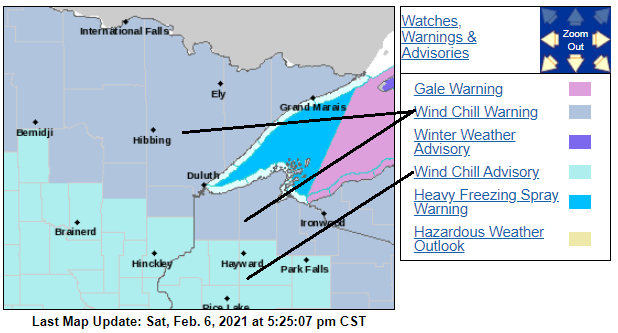
URGENT - WINTER WEATHER MESSAGE National Weather Service Duluth MN 405 PM CST Sat Feb 6 2021 ...PROLONGED PERIOD OF BITTERLY COLD TEMPERATURES AND WIND CHILLS... MNZ025-035-037-071015- /O.UPG.KDLH.WC.Y.0006.000000T0000Z-210209T1800Z/ /O.NEW.KDLH.WC.Y.0007.210207T1700Z-210209T1800Z/ /O.EXB.KDLH.WC.W.0001.210206T2205Z-210207T1700Z/ North Cass-Northern Aitkin-Carlton and South St. Louis- Including the cities of Walker, Hill City, and Duluth 405 PM CST Sat Feb 6 2021 ...WIND CHILL WARNING IN EFFECT UNTIL 11 AM CST SUNDAY... ...WIND CHILL ADVISORY IN EFFECT FROM 11 AM SUNDAY TO NOON CST TUESDAY... * WHAT...For the Wind Chill Warning, dangerously cold wind chills. Wind chills as low as 45 below zero. Wind chills as low as 40 below zero. Coldest values overnight and should warm to 20 below to around 25 below during the afternoon. * WHERE...North Cass, Northern Aitkin and Carlton and South St. Louis Counties. This includes the Tribal Lands of the Fond du Lac Band and the Mille Lacs Band, Big Sandy Lake area. * WHEN...For the Wind Chill Warning, until 11 AM CST Sunday. For the Wind Chill Advisory, from 11 AM Sunday to noon CST Tuesday. * IMPACTS...The dangerously cold wind chills could cause frostbite on exposed skin in as little as 10 minutes. * ADDITIONAL DETAILS...Additional advisories may be needed through the week. PRECAUTIONARY/PREPAREDNESS ACTIONS... Avoid outside activities if possible. When outside, make sure you wear appropriate clothing, a hat, and gloves. Use caution while traveling outside. Wear appropriate clothing, a hat, and gloves.
Central and southern Minnesota plus west-central Wisconsin remain in a wind chill advisory from Saturday evening through noon on Sunday:
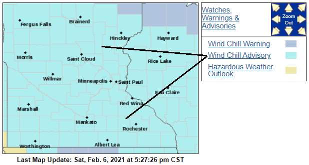
Twin Cities metro area wind chill temps will be in the 20s below zero to mid-30s below zero Saturday night into early Sunday.
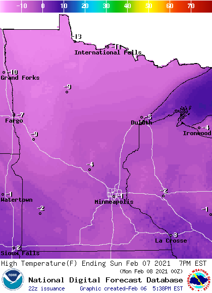
Sunday high temperatures will be below zero in most areas:
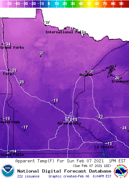
Sunday afternoon wind chills are coldest in northern Minnesota:
We can bundle up and limit our time outdoors in this weather, but our pets need some attention:

You can hear updated weather information for Minnesota and western Wisconsin on the MPR network, and you’ll see updated weather info on the MPR News live weather blog.
Snow stays south
Some light snow or flurries could spread across portions of far southern Minnesota from late Sunday morning into Sunday afternoon and evening.
The National Oceanic and Atmospheric Administration’s High Resolution Rapid-Refresh (HRRR) forecast model shows the potential precipitation pattern for Sunday and Sunday evening:
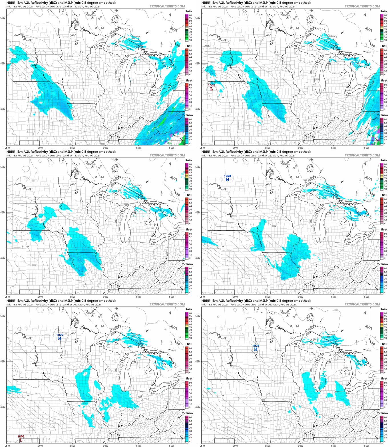
Any Sunday flakes should miss the Twin Cities metro area.
Cold air lingers
”High” temps in the Twin Cities metro area are projected to be around 4 above zero on Monday, then 6 above Tuesday, followed by 8 on Wednesday and 6 on Thursday. Our Friday high temp may be around zero. Those highs are cooler than our typical low temps for this time of year. We may see a bit of snow on Thursday.
Programming note
You can hear my live weather updates on MPR News at 7:35 a.m., 9:35 a.m. and 4:39 p.m. each Saturday and Sunday.

