
Weekend winds chills of minus 40 or lower for most of Minnesota
Southern Minnesota sees light snow Thursday
Go Deeper.
Create an account or log in to save stories.
Like this?
Thanks for liking this story! We have added it to a list of your favorite stories.


Thursday brings light snow and lower temperatures that linger through the weekend. Weekend wind chills may exceed 50 below for portions of northern Minnesota.
Thursday’s forecast
Tuesday and Wednesday were the slightly milder days of this cold outbreak in part because of a wind pattern that was briefly more southerly.
Winds have shifted again, and now under more westerly to northerly winds, temperatures are dipping even lower again.
The entire state started Thursday below zero, from negative 30s north to negative single digits south. A few temperatures even dropped below minus 40, making it the coldest morning for Minnesota so far this winter.
Turn Up Your Support
MPR News helps you turn down the noise and build shared understanding. Turn up your support for this public resource and keep trusted journalism accessible to all.
The wind chill makes those chilly air temperatures feel another 10 to 20 degrees colder for most of the state, although fortunately winds have been predominantly calm in the areas that dropped over 40 below.
Highs also stay below zero Thursday.

Besides the cold air, the other weather concern is a weather disturbance that will bring a light dusting of snow across southern Minnesota through the day, including for the Twin Cities in the afternoon hours. While accumulation should stay under an inch, it will be enough to cause some slick spots on the roads.

Dangerously cold weather continues
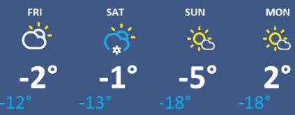
Temperatures remain frigid through the weekend, with most highs below zero, and brutally cold lows that will be at least 15 to 30 below zero, especially Saturday, Sunday and Monday mornings.
Here is that forecast for the Twin Cities:
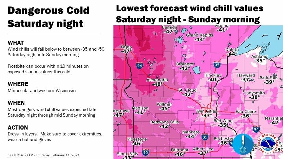
The wind continues to make the cold even more hazardous, with much of the state seeing wind chills of 30 to 50 below over the weekend, especially in the overnight and morning hours. All of the three mornings listed above have the arctic wind chills, but it currently looks like the most dangerous time will be overnight Saturday into Sunday morning, when many of the wind chills could hit 40 below, and northwestern Minnesota could exceed 50 below.
A slow warmup next week is expected to finally end this cold outbreak.
Programming note
You can hear my live weather updates on Minnesota Public Radio at 7:48 a.m. Monday through Friday morning.

