
Snow tapers Sunday evening; mild start to the week
Heaviest snow southern Minnesota
Go Deeper.
Create an account or log in to save stories.
Like this?
Thanks for liking this story! We have added it to a list of your favorite stories.


Snow will continue in many areas through Sunday afternoon, then taper off during the early evening hours.
The midday run of NOAA’s North American Mesoscale (NAM) forecast model shows the potential precipitation pattern from 3 p.m. Sunday through Sunday evening:
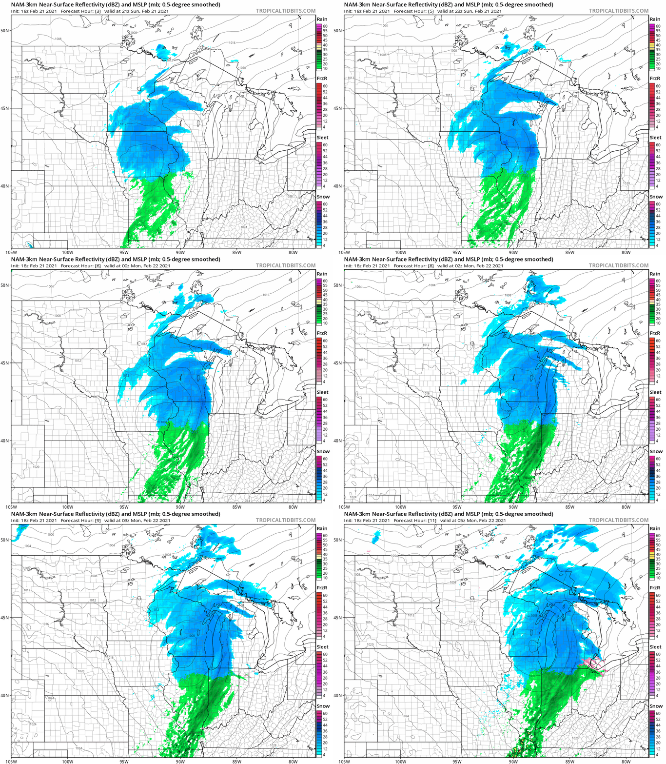
It may snow in a few spots that look dry in the forecast loop, but the general snow pattern looks appropriate for this system.
Much of the Twin Cities metro area could end up with around one inch of snow, with closer to two inches possible in parts of the south metro. Some three to four inch snow totals are possible in portions of southern Minnesota. A winter weather advisory continues until 6 p.m. today for the southern Minnesota counties shaded blue on the following map:
Turn Up Your Support
MPR News helps you turn down the noise and build shared understanding. Turn up your support for this public resource and keep trusted journalism accessible to all.

Here are details of the advisory that includes Mankato until 6 p.m.:
URGENT - WINTER WEATHER MESSAGE National Weather Service Twin Cities/Chanhassen MN 1250 PM CST Sun Feb 21 2021 ...ACCUMULATING SNOW EXPECTED OVER SOUTHERN MINNESOTA THROUGH THIS AFTERNOON... .A Winter Weather Advisory is in effect this afternoon for southern Minnesota. Around 3 or 4 inches of snow are expected. Light snow will taper off early this evening. MNZ082>085-220000- /O.EXA.KMPX.WW.Y.0006.000000T0000Z-210222T0000Z/ Watonwan-Blue Earth-Waseca-Steele- Including the cities of St James, Mankato, Waseca, and Owatonna 1250 PM CST Sun Feb 21 2021 ...WINTER WEATHER ADVISORY IN EFFECT UNTIL 6 PM CST THIS EVENING... * WHAT...Snow. Total snow accumulations of 3 to 4 inches. * WHERE...Watonwan, Blue Earth, Waseca and Steele Counties. * WHEN...Until 6 PM CST this evening. * IMPACTS...Plan on slippery road conditions. PRECAUTIONARY/PREPAREDNESS ACTIONS... Slow down and use caution while traveling. The latest road conditions for the state you are calling from can be obtained by calling 5 1 1. Road conditions can also be found at 511mn.org for Minnesota or 511wi.gov for Wisconsin.
And here are details of the advisory that includes Rochester until 6 p.m.:
URGENT - WINTER WEATHER MESSAGE National Weather Service La Crosse WI 1252 PM CST Sun Feb 21 2021 ...Snow Covered Roads, Slick Travel Quickly Developing... .Snow through the afternoon, causing slick travel for most of the area. The snow will quickly exit east by early to mid evening. Accumulations of 2 to 4 inches are expected with a few localized higher amounts possible. Plan on slick travel conditions as the snow moves in. MNZ086>088-220000- /O.EXA.KARX.WW.Y.0007.000000T0000Z-210222T0000Z/ Dodge-Olmsted-Winona- Including the cities of Dodge Center, Rochester, and Winona 1252 PM CST Sun Feb 21 2021 ...WINTER WEATHER ADVISORY IN EFFECT UNTIL 6 PM CST THIS EVENING... * WHAT...Snow with accumulations of 2 to 4 inches. * WHERE...Dodge, Olmsted and Winona Counties. * WHEN...Until 6 PM CST this evening. * IMPACTS...Plan on slippery road conditions. PRECAUTIONARY/PREPAREDNESS ACTIONS... Slow down and use caution while traveling. The latest road conditions for the state you are calling from can be obtained by calling 5 1 1.
Snow will also cause slick roads in many areas that are not in the winter weather advisories.
You can hear updated weather information for Minnesota and western Wisconsin on the MPR network, and you’ll see updated weather info on the MPR News live weather blog.
Minnesota road conditions can be found here. Wisconsin road conditions can be found here.
Temperature trends
Monday highs are expected to reach 40 degrees or higher in many areas:
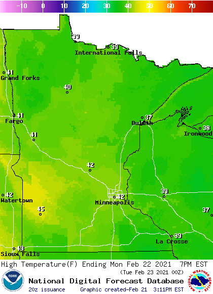
Far northern Minnesota and much of western Wisconsin may top out in the 30s.
Twin Cities metro area highs are projected to reach the lower 40s Monday and Tuesday, followed by mid 30s Wednesday, around 30 on Thursday and mid 30s Friday.
Programming note
You can hear my live weather updates on MPR News at 7:35 a.m., 9:35 a.m. and 4:39 p.m. each Saturday and Sunday.

