
Highs in the 50s and 60s by Sunday
Minnesota's snowpack is eroding under mild weather
Go Deeper.
Create an account or log in to save stories.
Like this?
Thanks for liking this story! We have added it to a list of your favorite stories.


The snowpack across Minnesota continues to disappear quickly due to mild temperatures that turn even higher over the weekend. Rain and snow chances return next week.
Here is a look at the snow cover across the state through Wednesday:

As you can see, we are now seeing significant areas of snow-free ground in portions of western and southern Minnesota. The cold snow on the ground keeps temperatures from getting too high, but now that the state is seeing snow disappear so rapidly, daytime temperatures can rise even more.
In fact, the Twin Cities hit its first 50 degree reading of the year Wednesday, bringing the warmest weather since early December.
Turn Up Your Support
MPR News helps you turn down the noise and build shared understanding. Turn up your support for this public resource and keep trusted journalism accessible to all.
Thursday’s forecast
Thursday had another mild start for early March, with morning temperatures ranging from teens north to a few 30s south. This meant the snow melt from Wednesday refroze in most areas, so keep an eye out for black ice again Thursday morning.
The quiet weather trend continues with mostly sunny skies Thursday, although it will be a little breezy.
Highs for most of the state make it back into the 40s, with a few 50s south.

The mild air and sunshine mean significant snow melt continues through the day.
Turning even warmer
The pattern stays very consistent through Saturday, with mostly sunny skies and mild highs in the 40s, with occasional 50s south and west.
This also continues the thaw, and that snow melt moisture keeps bringing a few spots of morning fog and morning ice caused by refreezing.
By Sunday, the winds shift, bringing us gusty winds from the south.
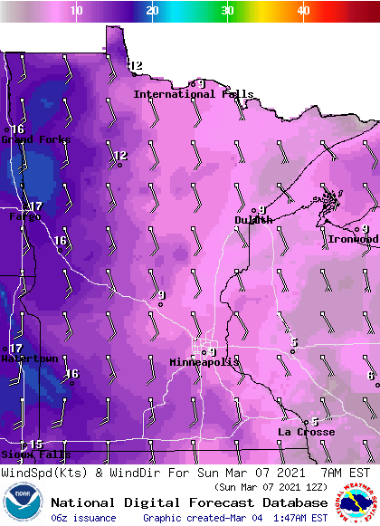
That warm wind flow, combined with the reducing snow cover should push temperatures for most of the state into the 50s, with a few 60s south, including possibly for the Twin Cities.
Temperatures then remain high for March for most of next week, with highs predominantly in the 40s to 50s north and 50s to 60s south.
Here is that forecast for the Twin Cities:

Precipitation returns
Dry skies are likely to dominate the forecast until Monday.
The quiet pattern finally shifts next week though, including a storm system that could impact northern Minnesota starting Monday, before bringing more widespread impacts Tuesday and Wednesday.

It currently appears that due to the mild weather the precipitation will come as a rain and snow mix north and predominantly rain south.
Amounts are still uncertain as the storm is several days away, but any precipitation would be very beneficial as the state is drier than average.
We’ll keep you posted as that weather system approaches!
Programming note
You can hear my live weather updates on Minnesota Public Radio at 7:48 a.m. Monday through Friday morning.

