
April-like temps linger a couple of days; a look at the week ahead
Snow and cold index update
Go Deeper.
Create an account or log in to save stories.
Like this?
Thanks for liking this story! We have added it to a list of your favorite stories.


The Sunday high temp at Minneapolis-St. Paul International Airport was 62 degrees. That’s our average Twin Cities high on April 23! Our average March 7 high temp is only 37. The last time that our official Twin Cities high was in the 60s was on Nov. 7.
Temps will stay well above normal for another couple of days.
Temperature trends
Monday highs will range from the low-to-mid 60s in southwestern Minnesota to the upper 40s in far northeastern Minnesota:
Turn Up Your Support
MPR News helps you turn down the noise and build shared understanding. Turn up your support for this public resource and keep trusted journalism accessible to all.
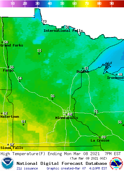
Many metro area locations will top out around 60 degrees.
With high pressure nearby, winds will be much lighter on Monday. It’ll be a bit breezy by afternoon in far western Minnesota:
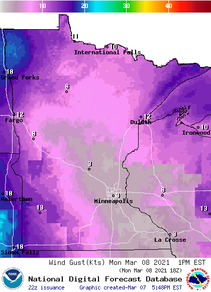
Plotted gusts are in knots, with 13 knots equal to around 15 mph.
Back to temperatures, Tuesday highs will range from the lower 70s in southwestern Minnesota to the 50s in far northeastern Minnesota. We could top out around 66 in the Twin Cities Tuesday afternoon, which would break our current March 9 record high of 61 degrees.
Twin Cities metro area highs are projected to be in the lower 50s on Wednesday, followed by upper 40s Thursday and mid 40s on Friday.
Next chance of rain or snow?
We’ll probably see some periods of rain Wednesday and Wednesday night. The Canadian forecast model (GEM, or Global Environmental Multiscale model) is showing the following precipitation pattern from Wednesday morning through Thursday morning:
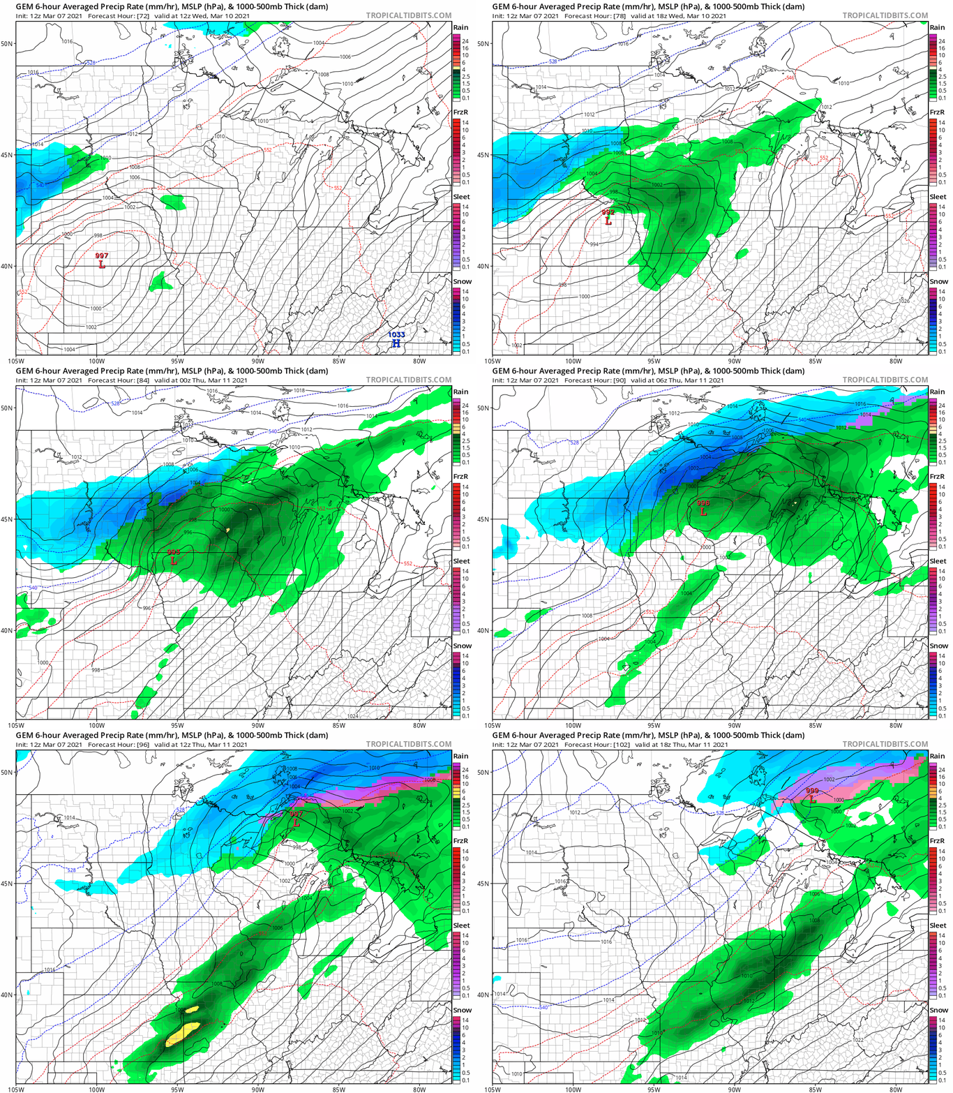
Some flakes could mix with the rain in the metro area Wednesday night, and parts of central and northern Minnesota could see a mix of snow and rain Wednesday evening into early Thursday morning.
You can hear updated weather information for Minnesota and western Wisconsin on the MPR network, and you’ll see updated weather info on the MPR News live weather blog.
Snow and cold index
The Minnesota State Climatology Office compares the severity of our winter seasons by tallying points in a snow and cold index.
Here’s how they describe the index:
The Twin Cities Snow and Cold Index (SCI) is an attempt to weigh the relative severity of winter when compared with winters of the past. The SCI assigns single points for daily counts of maximum temperatures 10 degrees F or colder, and daily minimums of 0 degrees F or colder. If the minimum temperature drops to -20 degrees or colder greater, eight points are attributed to that day. Snowfall totals of one inch or greater in a day receive one point. Four-inch snowfalls generate four points for the day, an eight-inch snowfall receives a whopping 16 points. To quantify the duration of winter, one point is tallied for every day with a snow depth of 12 inches or greater.
So far this 2020-2021 winter season we’ve racked up 68 points in the snow and cold index, which puts this winter in the low end of moderate on the severity scale:
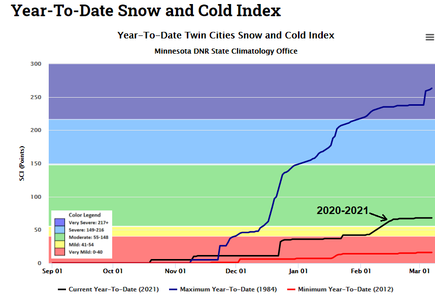
According to the Climatology Office:
The lowest SCI score was the winter of 2011-2012 with 16 points. The most severe winter is 1916-1917 with 305 SCI points.
In recent decades, the winter of 1983-1984 was a memorably severe winter in the Twin Cities, with an SCI score over 250. The Twin Cities had 98.6 inches of snow during that 1983-1984 winter season.
Programming note
You can hear my live weather updates on MPR News at 7:35 a.m., 9:35 a.m. and 4:39 p.m. each Saturday and Sunday.

