
Record warmth, especially on Tuesday
Wednesday brings needed rain to much of Minnesota
Go Deeper.
Create an account or log in to save stories.
Like this?
Thanks for liking this story! We have added it to a list of your favorite stories.


Temperatures remain warm through Tuesday, with more record highs expected. Then a storm Wednesday provides beneficial rain and turns temperatures cooler.
Monday’s forecast
Following warm weather Sunday, that included a couple record highs in places such as Bemidji (Sunday’s temperature of 56 beat the previous March 7 record of 54), the state started off very mild Monday morning. Morning temperatures from the mid-20s to upper 30s were closer to average highs for this time of year versus morning lows.
A weak cold front that passed through the state overnight will drop highs just a couple degrees from Sunday’s warmth. Afternoon temperatures range from the upper 40s north to lower 60s south, which is still 20 degrees above average for most of the state.
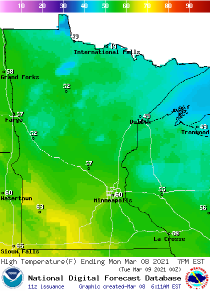
This is warm enough to possibly set records in spots including Moorhead, where the current record high for March 8th is 54.
Turn Up Your Support
MPR News helps you turn down the noise and build shared understanding. Turn up your support for this public resource and keep trusted journalism accessible to all.
Winds are also expected to be lighter Monday, and mostly sunny skies prevail.
Widespread records, then cooler
For the majority of Minnesota, Tuesday brings the warmest day of this mild pattern, with highs ranging from the 50s north to a few 70s southwest, which will be about 30 degrees above average. This could shatter record highs on Tuesday, including for the Twin Cities, which could make it into upper 60s, while the current record for March 9 is 61.
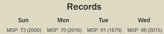
It helps that many places have slightly cooler records on March 9th, making the records easier to beat. For example, the record highs for the Twin Cities Sunday and Monday are in the 70s, so Tuesday’s expected warmth would not have set records had it occurred on those days.
A weather system midweek finally brings back cooler temperatures, with highs predominantly in the 40s, with a few 30s north through the end of the week.
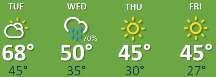
Although that will be a noticeable drop from the current warmth, it is still about 10 degrees above average.
Mid-week storm
Clouds increase Tuesday and during the overnight Tuesday, rain is expected to start moving in from the south. By Wednesday morning, most of southern Minnesota sees rain that lingers through the day, and there could even be a couple thunderstorms.
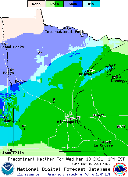
For northern Minnesota, a light mix of rain and snow is forecast. The precipitation clears out through the overnight Wednesday, with dry skies and more sunshine returning for the rest of the week.
It currently looks like the southern half of Minnesota could see a quarter to a half inch rain, with a few isolated higher amounts as you get farther south. Precipitation gets sparser as you head north. Any moisture the state gets will be very beneficial, as the entire state is currently experiencing abnormally dry conditions.
Programming note
You can hear my live weather updates on Minnesota Public Radio at 7:48 a.m. Monday through Friday morning.

