
Statewide record highs expected Tuesday
Gusty winds from the south drive temperatures warmer
Go Deeper.
Create an account or log in to save stories.
Like this?
Thanks for liking this story! We have added it to a list of your favorite stories.


Warm and windy conditions will shatter record highs by 5 to 10 degrees across much of Minnesota.
Tuesday’s forecast
In the wake of another warm day Monday, and with winds from the southeast overnight, temperatures stayed very mild. Much of Minnesota is in the 40s to start Tuesday, which is 20 to 30 degrees above average for most of the state.
That wind flow shifts more southerly through the day, and winds increase, gusting over 20 mph and possibly over 30s mph at times.
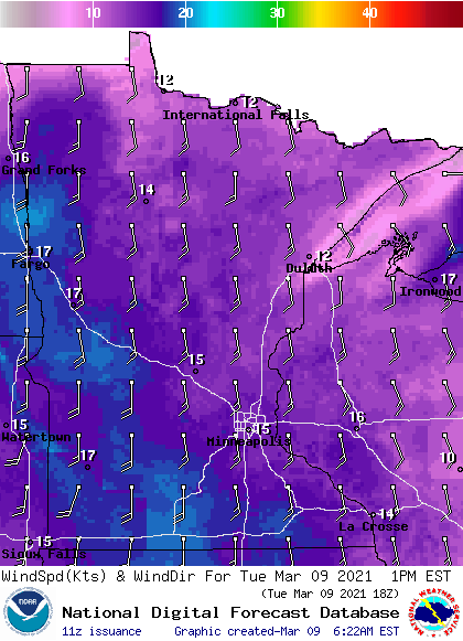
This keeps a very warm flow throughout the state, putting most of Minnesota in the 60s by the afternoon, with a few 70s possible southwest. This will shatter records across the state, and in the case of the Twin Cities, it will break a record going back over 140 years.

Other record highs that are likely to be broken Tuesday (for the date of March 9) include Rochester’s current record of 59, Brainerd’s current record of 58 and Moorhead’s current record of 58. Most of these records will be beaten by at least 5 degrees.
A complex storm that brings rain and snow Wednesday cools the warm trend. That extended forecast will be updated around 9 a.m.
Programming note
You can hear my live weather updates on Minnesota Public Radio at 7:48 a.m. Monday through Friday morning.
Turn Up Your Support
MPR News helps you turn down the noise and build shared understanding. Turn up your support for this public resource and keep trusted journalism accessible to all.

