
Breezy and cooler Thursday; morning snow in northeastern Minn.
Go Deeper.
Create an account or log in to save stories.
Like this?
Thanks for liking this story! We have added it to a list of your favorite stories.


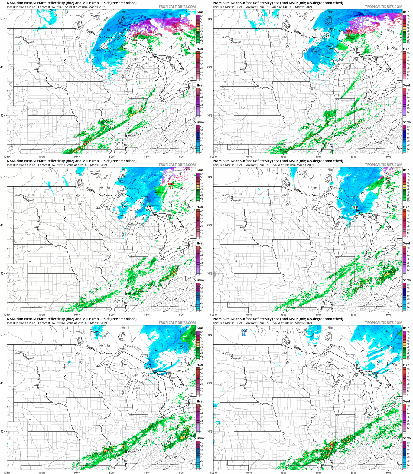
The snow that began on Wednesday continues in northeastern Minnesota Thursday morning.
The National Oceanic and Atmospheric Administration’s North American Mesoscale (NAM) forecast model shows the potential precipitation pattern:
Winter storm warnings continue until 9 a.m. in northeastern Minnesota, with winter weather advisories in parts of northwestern Wisconsin:
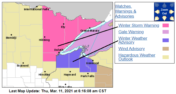
Here are details of the warnings and advisories:
Turn Up Your Support
MPR News helps you turn down the noise and build shared understanding. Turn up your support for this public resource and keep trusted journalism accessible to all.
URGENT - WINTER WEATHER MESSAGE National Weather Service Duluth MN 549 AM CST Thu Mar 11 2021 ...WINTER STORM WINDING DOWN... .Light to moderate snow was still falling over much of the northeast quarter of Minnesota and northern Wisconsin early this morning. A few warm spots in northern Wisconsin were still picking up drizzle or light rain and should see a change to snow before sunrise. Precipitation will end from southwest to northeast this morning. MNZ011-012-019>021-037-111500- /O.CON.KDLH.WS.W.0003.000000T0000Z-210311T1500Z/ North St. Louis-Northern Cook and Lake-Central St. Louis- Southern Lake-Southern Cook-Carlton and South St. Louis- Including the cities of Ely, Isabella, Hibbing, Two Harbors, Silver Bay, Grand Marais, and Duluth 549 AM CST Thu Mar 11 2021 ...WINTER STORM WARNING REMAINS IN EFFECT UNTIL 9 AM CST THIS MORNING... * WHAT...Heavy snow. Additional snow accumulations of up to two inches. Winds gusting as high as 35 mph. * WHERE...Central St. Louis, Northern Cook and Lake, North St. Louis, Southern Cook, Southern Lake and Carlton and South St. Louis Counties. This includes the Tribal Lands of the Fond du Lac Band, the Grand Portage Reservation and the Bois Forte Band, Lake Vermilion and, Nett Lake areas. * WHEN...Until 9 AM CST this morning. * IMPACTS...Plan on slippery road conditions. The hazardous conditions could impact the morning commute. PRECAUTIONARY/PREPAREDNESS ACTIONS... If you must travel, keep an extra flashlight, food, and water in your vehicle in case of an emergency. The latest road conditions can be obtained by calling 5 1 1. Road conditions can also be found at 511mn.org for Minnesota or 511wi.gov for Wisconsin.
You can hear updated weather information for Minnesota and western Wisconsin on the MPR network, and you’ll see updated weather info on the MPR News live weather blog.
Minnesota road conditions can be found here. Wisconsin road conditions can be found here.
Snow totals
There have been some impressive snow totals in parts of northern Minnesota. I saw 11.6 inches tallied about 7 miles southwest of Pine River, in Cass County. Eight inches of new snow were measured at McKinley, in St. Louis County. Duluth reported 7 inches of new snow.
You can look at the National Weather Service plot of snowfall reports here. This is how the NWS map looked around 6 a.m.:
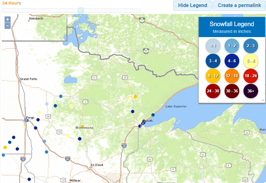
You can hover over any data point on the linked NWS site to get the location and snow total plus the time of the measurement. Additional snow totals will be coming in during the morning.
Windy Thursday
Wind gusts of 20 to 30 mph are expected, with winds tapering a bit by late afternoon:
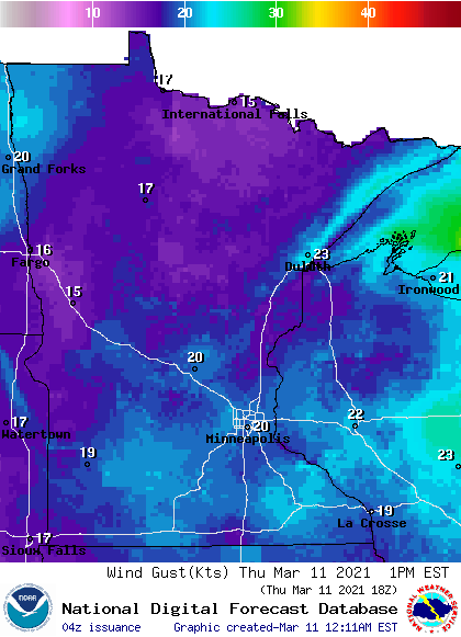
Plotted gusts are in knots, with 20 knots equal to 23 mph.
Highs will be mainly in the 40s, with some lower 50s in southeastern Minnesota:
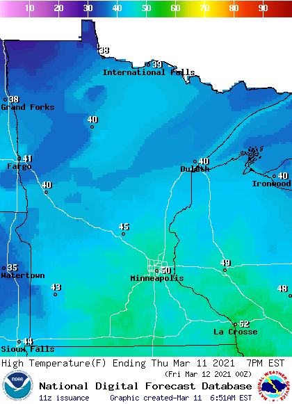
Our average Twin Cities high temp is 39 degrees this time of year.
Update
This Updraft blog will be updated around 9:30 a.m. with details on our weekend weather.
Programming note
You can hear my live weather updates on MPR News at 7:35 a.m., 9:35 a.m. and 4:39 p.m. each Saturday and Sunday.

