
50s and possibly 60s for part of the weekend
Another round of snow is likely Monday
Go Deeper.
Create an account or log in to save stories.
Like this?
Thanks for liking this story! We have added it to a list of your favorite stories.


Following cooler weather Friday, temperatures rebound over the weekend, but another storm system brings back cooler weather and snow chances to start next week.
Friday’s weather
Behind a cold front that passed through Minnesota from Tuesday evening through the overnight, the state started the day seasonably cold Friday.
Morning lows ranged from single-digits north to 20s south.
Across much of the state, Friday also brings the coolest highs of the week, from 20s in the Arrowhead to 30s in other parts of northern Minnesota and 40s for the rest of the state.
Turn Up Your Support
MPR News helps you turn down the noise and build shared understanding. Turn up your support for this public resource and keep trusted journalism accessible to all.
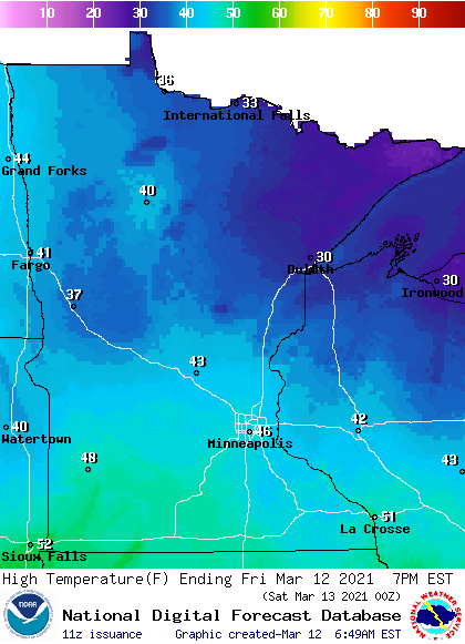
For perspective, the average high in International Falls is 33 for March 12, putting Friday’s high right about average. The Twin Cities average high this time of year is 39, so Friday will still be slightly above average, but not as mild as the rest of the week.
Under the influence of high pressure, dry and mostly sunny skies are expected during the day, along with relatively light winds.
Extended forecast
Saturday stays sunny, and with winds shifting more south and west, temperatures rise again. Highs will be in the 50s, with temperatures near 60 south.
By Sunday, a storm that is expected to track well south of the state could start bringing more clouds and light rain into southern Minnesota.
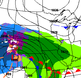
Temperatures will also be not quite as warm as Saturday, with highs predominantly in the 40s and a few 50s south.
The storm brings more widespread impacts Monday that could linger into Tuesday. There is still a lot of uncertainty with that storm, especially with how far north the moisture makes it into Minnesota and exact temperatures contributing to how much of the precipitation falls as rain versus snow.
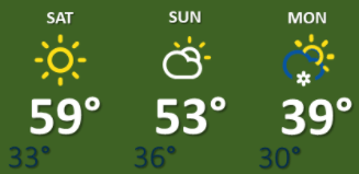
Southern Minnesota is likely to see at least 1 or 2 inches of snow, but that could be higher depending on exactly how low temperatures get. Highs are currently expected to be in the 30s and low 40s Monday.
Here is that Twin Cities forecast through Monday:
That storm should move out by early Tuesday, then the rest of the week remains slightly above average, with highs predominantly in the 40s.
Programming note
You can hear my live weather updates on Minnesota Public Radio at 7:48 a.m. Monday through Friday morning.

