
Delightful Saturday weather
Winter storm watch portions of southern Minn. Sunday night/Monday
Go Deeper.
Create an account or log in to save stories.
Like this?
Thanks for liking this story! We have added it to a list of your favorite stories.


We’ll have mild (for March) temps this weekend. Our average Twin Cities high temperature is 40 degrees on March 13. Metro area highs are expected to reach the upper 50s to around 60 this Saturday afternoon.
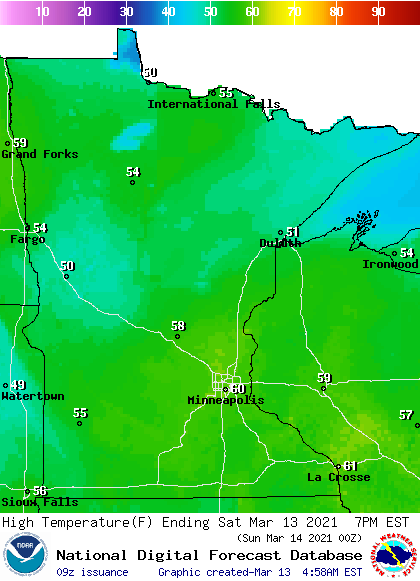
A few spots in southeastern Minnesota could also touch 60 today, but most of Minnesota will see Saturday highs in the 50s, with a few 40s in far northeastern Minnesota:
Saturday wind gusts will be fairly light, in the 10-15 mph range in most areas, but a bit higher gusts are expected in far northern Minnesota:
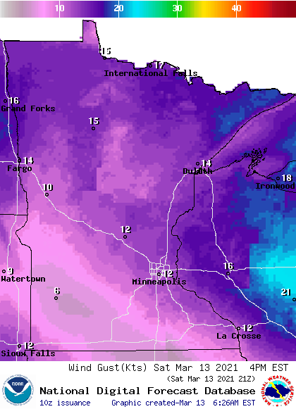
Plotted gusts are in knots, with 12 knots equal to about 14 mph.
Turn Up Your Support
MPR News helps you turn down the noise and build shared understanding. Turn up your support for this public resource and keep trusted journalism accessible to all.
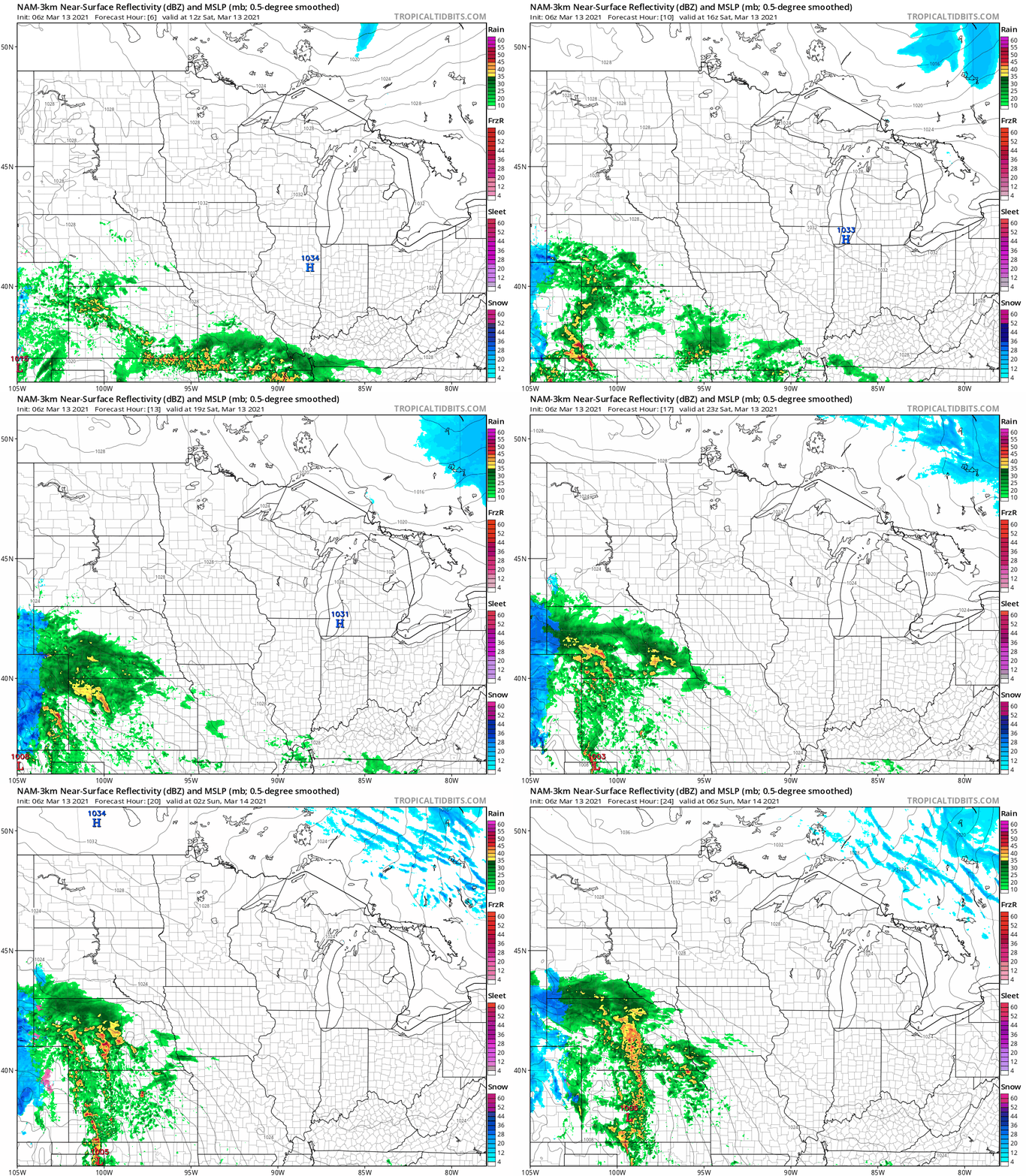
No rain or snow for Saturday
It’ll be a dry Saturday in Minnesota and western Wisconsin. The National Oceanic and Atmospheric Administration’s North American Mesoscale (NAM) forecast model shows the potential precipitation pattern for Saturday and Saturday evening:
Peek ahead to Monday
A strong low pressure system is bringing heavy snow to portions of Colorado today. That low could spread showers into southwestern Minnesota Sunday evening, then the showers turn to snow Sunday night as the precipitations spreads northeastward.
There is the potential for heavy snow in portions of southern Minnesota Sunday night/Monday:
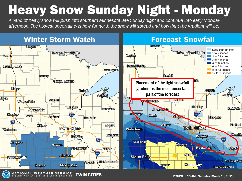
A winter storm watch starts at 10 p.m. Sunday in southwestern Minnesota and continues until 1 p.m. Monday. South-central Minnesota has a winter storm watch that starts at 1 a.m. Monday and continues until 4 p.m. Monday:
URGENT - WINTER WEATHER MESSAGE National Weather Service Twin Cities/Chanhassen MN 322 AM CST Sat Mar 13 2021 ...HEAVY SNOW POSSIBLE ACROSS SOUTHERN MINNESOTA LATE SUNDAY NIGHT INTO MONDAY... .A Winter Storm Watch is in effect late Sunday night through early Monday afternoon south of a line from Canby, to Olivia, Gaylord, Le Center, and Owatonna. A band of precipitation will lift northeast into southern Minnesota late Sunday night, quickly becoming all snow. The snow will be heavy at times through Monday morning, then taper off during the afternoon. Total accumulation of 5 to 8 inches are possible. MNZ064-065-067-073>076-082>085-091>093-132100- /O.NEW.KMPX.WS.A.0005.210315T0600Z-210315T2100Z/ Yellow Medicine-Renville-Sibley-Redwood-Brown-Nicollet-Le Sueur- Watonwan-Blue Earth-Waseca-Steele-Martin-Faribault-Freeborn- Including the cities of Granite Falls, Olivia, Gaylord, Redwood Falls, New Ulm, St Peter, Le Sueur, St James, Mankato, Waseca, Owatonna, Fairmont, Blue Earth, and Albert Lea 322 AM CST Sat Mar 13 2021 ...WINTER STORM WATCH IN EFFECT FROM LATE SUNDAY NIGHT THROUGH MONDAY AFTERNOON... * WHAT...Heavy snow possible. Total snow accumulations of 5 to 8 inches possible. * WHERE...Portions of central, south central, southwest and west central Minnesota. * WHEN...From late Sunday night through Monday afternoon. * IMPACTS...Travel could be very difficult. The hazardous conditions could impact the morning or evening commute. PRECAUTIONARY/PREPAREDNESS ACTIONS... Monitor the latest forecasts for updates on this situation.
You can hear updated weather information for Minnesota and western Wisconsin on the MPR network, and you’ll see updated weather info on the MPR News live weather blog.
Daylight saving time returns on Sunday
We return to Daylight Saving Time at 2 a.m. this Sunday:
Programming note
You can hear my live weather updates on MPR News at 7:35 a.m., 9:35 a.m. and 4:39 p.m. each Saturday and Sunday.

