
A breezy Sunday; snow late Sunday night and Monday
Heaviest snow southern Minn. on Monday
Go Deeper.
Create an account or log in to save stories.
Like this?
Thanks for liking this story! We have added it to a list of your favorite stories.


The daylight hours of Sunday will be breezy.
Highs will be mainly in the 40s, with 30s in northeastern Minnesota:
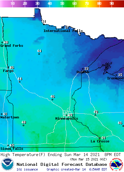
A few spots in the Twin Cities metro area and southeastern Minnesota may touch 50.
Winds pick up today, with gusts of 20 to 25 mph in many areas:
Turn Up Your Support
MPR News helps you turn down the noise and build shared understanding. Turn up your support for this public resource and keep trusted journalism accessible to all.

Plotted gusts are in knots, with 20 knots equal to 23 mph. Wind gusts could approach 30 mph Sunday afternoon in southwestern Minnesota.
Snow returns Sunday night and lingers into Monday
A low pressure system will spread showers into southwestern Minnesota Sunday evening, then the showers turn to snow by late evening and the snow spreads to the east and northeast. There’s the potential for heavy snow in portions of southern Minnesota late Sunday night and Monday.
The National Oceanic and Atmospheric Administration’s North American Mesoscale (NAM) forecast model shows the potential precipitation pattern for Sunday evening through Monday evening:
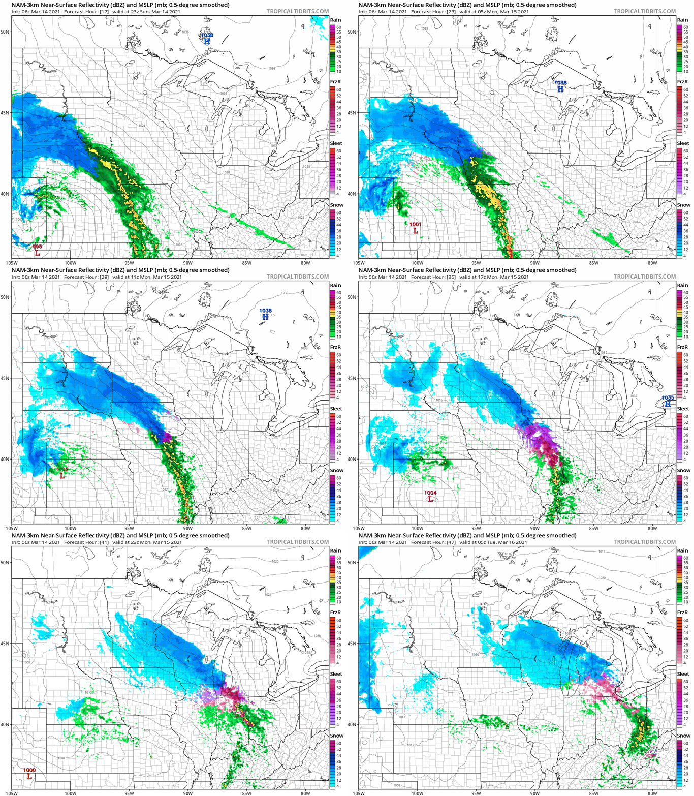
The snow may mix with drizzle or freezing drizzle in some areas on Monday.
Forecast snow amounts through Monday are highest in southwestern and south-cenral Minnesota:

In the pink shaded areas on the following map, winter storm warnings start at 1 a.m. Monday and continue until 4 p.m. Monday:
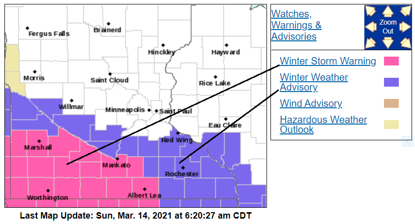
Monday winter weather advisories are shaded blue.
Here are details of the warnings and advisories:
URGENT - WINTER WEATHER MESSAGE National Weather Service Twin Cities/Chanhassen MN 328 AM CDT Sun Mar 14 2021 ...HEAVY SNOW ACROSS SOUTHERN MINNESOTA LATE TONIGHT INTO MONDAY... .A Winter Storm Warning is in effect from 1 AM tonight to 4 PM CDT Monday for areas south of a line from Redwood Falls to Mankato and Waseca. A Winter Weather Advisory is in effect for the rest of southern Minnesota from 4 AM to 4 PM CDT Monday. A band of precipitation will lift northeast into southern Minnesota late tonight, quickly becoming all snow. This will be a heavy, wet snow with rates of over an inch per hour possible. The snow will taper off during the late morning into early afternoon on Monday. Total accumulations of 5 to 8 inches are expected in the warning area with 3 to 5 inches expected in the advisory area. MNZ073-074-082>084-091>093-142000- /O.UPG.KMPX.WS.A.0005.210315T0600Z-210315T2100Z/ /O.NEW.KMPX.WS.W.0004.210315T0600Z-210315T2100Z/ Redwood-Brown-Watonwan-Blue Earth-Waseca-Martin-Faribault- Freeborn- Including the cities of Redwood Falls, New Ulm, St James, Mankato, Waseca, Fairmont, Blue Earth, and Albert Lea 328 AM CDT Sun Mar 14 2021 ...WINTER STORM WARNING IN EFFECT FROM 1 AM TO 4 PM CDT MONDAY... * WHAT...Heavy mixed precipitation expected. Total snow accumulations of 5 to 8 inches and ice accumulations of a light glaze. * WHERE...Portions of south central and southwest Minnesota. * WHEN...From 1 AM to 4 PM CDT Monday. * IMPACTS...Travel could be very difficult. Patchy blowing snow could significantly reduce visibility. The hazardous conditions could impact the morning and evening commutes. PRECAUTIONARY/PREPAREDNESS ACTIONS... If you must travel, keep an extra flashlight, food, and water in your vehicle in case of an emergency. The latest road conditions for the state you are calling from can be obtained by calling 5 1 1. Road conditions can also be found at 511mn.org for Minnesota or 511wi.gov for Wisconsin.
The Twin Cities metro area is not in a winter weather advisory for Monday, but we’ll see some snow, which could be mixed with rain or freezing drizzle at times. Some forecast models show two to three inches of snow in the metro area on Monday, with the highest totals in the south and southwest metro….check updates.
You can hear updated weather information for Minnesota and western Wisconsin on the MPR network, and you’ll see updated weather info on the MPR News live weather blog.
Programming note
You can hear my live weather updates on MPR News at 7:35 a.m., 9:35 a.m. and 4:39 p.m. each Saturday and Sunday.

