
Heavy snow in parts of southern Minn. Monday; cool start to the week
Temps rebound nicely Wednesday through Friday
Go Deeper.
Create an account or log in to save stories.
Like this?
Thanks for liking this story! We have added it to a list of your favorite stories.


By this point in March, many of us are ready to put our snow shovels into storage. It’s a bit too early to do that.
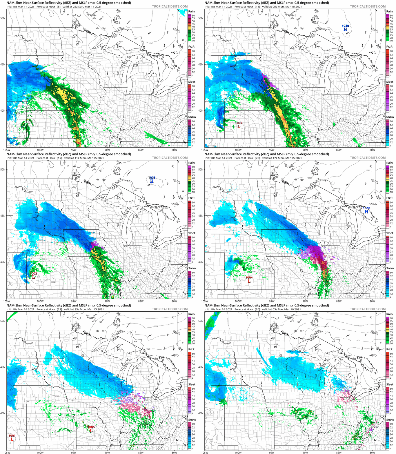
A low pressure system will spin moisture over much of Minnesota and parts of Wisconsin Sunday night and Monday. A mix of rain and snow is possible in southwestern Minnesota Sunday evening, then the mix changes to all snow and expands to the northeast and east overnight and Monday.
The National Oceanic and Atmospheric Administration’s North American Mesoscale (NAM) forecast model shows the potential precipitation pattern for Sunday evening through Monday evening:
Snow amounts and advisories/warnings
Turn Up Your Support
MPR News helps you turn down the noise and build shared understanding. Turn up your support for this public resource and keep trusted journalism accessible to all.
Forecast snow amounts through Monday are highest in southwestern and south-central Minnesota, where some 5 to 8+ inch totals are possible:
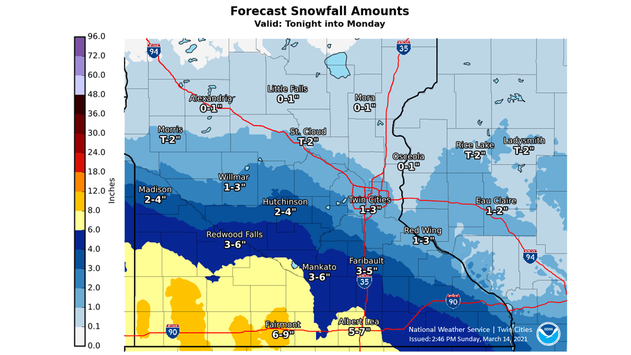
The snow may be mixed with light rain or drizzle/freezing drizzle in some areas.
Snow amounts through Monday could approach 2 to 3 inches in the south and southwest parts of the Twin Cities metro area, with around an inch in the far northeast metro. Check forecast updates Monday morning.
Here’s the NWS estimate of snow arrival times at various locations:
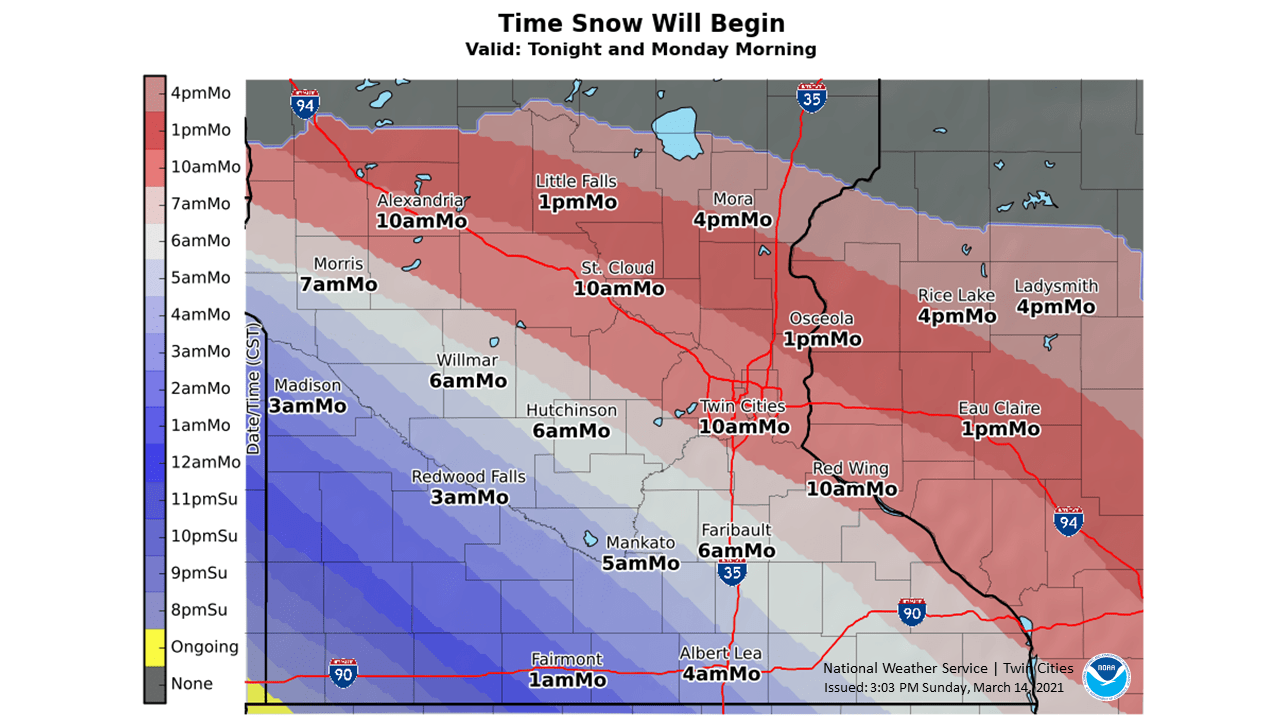
Snow could begin in the southwest part of the Twin Cities metro area around mid-morning, but the flakes could hold off until afternoon in the northeastern part of the metro area.
Winter storm warnings start at 1 a.m. Monday and continue until 4 p.m. Monday in the pink-shaded southern Minnesota counties on the following map:
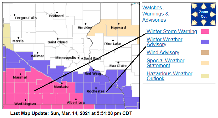
Monday winter weather advisories are shaded blue.
Here are details of the warnings and advisories:
URGENT - WINTER WEATHER MESSAGE National Weather Service Twin Cities/Chanhassen MN 603 PM CDT Sun Mar 14 2021 ...HEAVY SNOW ACROSS SOUTHERN MINNESOTA LATE TONIGHT INTO MONDAY... .A Winter Storm Warning is in effect from 1 AM tonight to 4 PM CDT Monday for areas south of a line from Redwood Falls to Mankato and Waseca. A Winter Weather Advisory is in effect for the rest of southern Minnesota from 4 AM to 4 PM CDT Monday. A band of precipitation will lift northeast into southern Minnesota tonight, quickly becoming all snow. Heavy, wet snow is expected with rates of over an inch per hour possible. The snow will taper off during the late afternoon on Monday, although a period of freezing drizzle may occur. Total accumulations of 5 to 8 inches are expected in the warning area with 3 to 5 inches expected in the advisory area. Snow accumulations will vary significantly over relatively short distances due to localized heavier snow. MNZ073-074-082>084-091>093-151000- /O.CON.KMPX.WS.W.0004.210315T0600Z-210315T2100Z/ Redwood-Brown-Watonwan-Blue Earth-Waseca-Martin-Faribault- Freeborn- Including the cities of Redwood Falls, New Ulm, St James, Mankato, Waseca, Fairmont, Blue Earth, and Albert Lea 603 PM CDT Sun Mar 14 2021 ...WINTER STORM WARNING REMAINS IN EFFECT FROM 1 AM TO 4 PM CDT MONDAY... * WHAT...Heavy mixed precipitation expected. Total snow accumulations of 5 to 8 inches and ice accumulations of a light glaze. * WHERE...Portions of south central and southwest Minnesota. * WHEN...From 1 AM to 4 PM CDT Monday. * IMPACTS...Travel could be very difficult. Patchy blowing snow could significantly reduce visibility. The hazardous conditions could impact the morning or evening commute. PRECAUTIONARY/PREPAREDNESS ACTIONS... If you must travel, keep an extra flashlight, food, and water in your vehicle in case of an emergency. The latest road conditions for the state you are calling from can be obtained by calling 5 1 1. Road conditions can also be found at 511mn.org for Minnesota or 511wi.gov for Wisconsin.
You can hear updated weather information for Minnesota and western Wisconsin on the MPR network, and you’ll see updated weather info on the MPR News live weather blog.
Keep in mind that March snows often melt within a few days.
Temperature trends
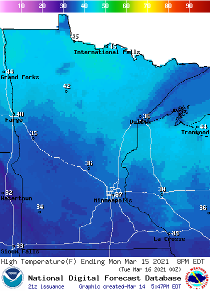
High temps during the daylight hours of Monday will be mainly in the 30s to the south, with 40s in parts of northern Minnesota:
It’ll be breezy again on Monday, with gusts of 20 to 25 mph in many areas:
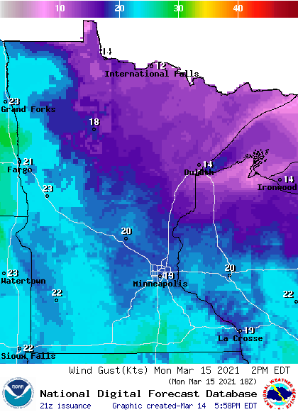
Plotted gusts are in knots, with 20 knots equal to 23 mph.
Back to temperatures, Twin Cities metro area highs are projected to reach the lower 40s Tuesday, followed by upper 40s Wednesday, 50 on Thursday and lower 50s Friday. An early look at next weekend shows highs in the 50s.
Warmer-than-normal temps may then linger into the following week. The NWS Climate Prediction Center shows a tendency for above-normal temps in Minnesota and western Wisconsin from March 22 through March 28:
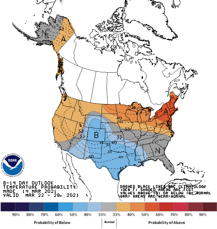
We’ll see if that outlook changes.
Programming note
You can hear my live weather updates on MPR News at 7:35 a.m., 9:35 a.m. and 4:39 p.m. each Saturday and Sunday.

