
Much of the state stays gray Wednesday
Northern Minnesota could be the warm spot again with more sunshine
Go Deeper.
Create an account or log in to save stories.
Like this?
Thanks for liking this story! We have added it to a list of your favorite stories.


Morning fog and mostly cloudy skies prevail across much of Minnesota again Wednesday.
Wednesday’s forecast
Thanks to low-level moisture and cloud cover overnight, temperatures Wednesday are starting mild. Most of the state has morning lows in the upper 20s and low 30s, which range from a few degrees above average in southern Minnesota to almost 20 degrees above average north.
That moisture along with light winds has led to fog again for central and southern Minnesota that will lift by midmorning. There is also a disturbance which brought light snow and a little freezing precipitation across Minnesota that is just clearing into Wisconsin as of 7 a.m.
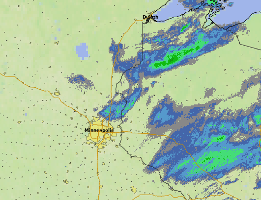
Behind that, there are no significant chances for additional precipitation Wednesday, but the cloud cover remains stubborn. Northern Minnesota should see some breaks of sunshine by the afternoon, but sunshine is likely to be more limited south.
Because of that, the northern edge of the state will make it into the 40s, but a few parts of southern Minnesota may struggle to get out of the 30s where clouds persist.
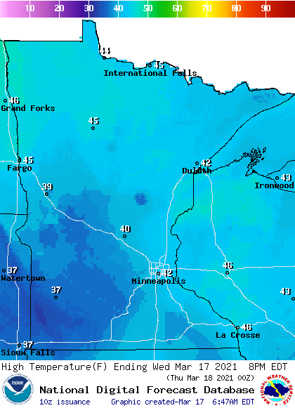
The return of drier air Thursday means more sunshine across the state and temperatures that will be on the rise again. That extended forecast will be updated by 9 a.m.
Programming note
You can hear my live weather updates on Minnesota Public Radio at 7:48 a.m. Monday through Friday morning.
Turn Up Your Support
MPR News helps you turn down the noise and build shared understanding. Turn up your support for this public resource and keep trusted journalism accessible to all.

