
Sunshine and milder weather the second half of the week
Wednesday stays gloomy for much of the state
Go Deeper.
Create an account or log in to save stories.
Like this?
Thanks for liking this story! We have added it to a list of your favorite stories.


After another gloomy day Wednesday, more sunshine and milder temperatures prevail through the end of the week.
Wednesday’s forecast
Thanks to low-level moisture and cloud cover overnight, temperatures Wednesday started mild. Most of the state saw morning lows in the upper 20s and low 30s, which ranged from a few degrees above average in southern Minnesota to almost 20 degrees above average north.
That moisture along with light winds led to fog again for central and southern Minnesota that will lift by midmorning. There was also a disturbance which brought light snow and a little freezing precipitation across Minnesota that cleared into Wisconsin earlier Wednesday morning. It did leave a new dusting of snow on the ground though for places including the Twin Cities, and a few light snow showers will linger in the Arrowhead through the morning.
Behind that, there are no significant chances for additional precipitation Wednesday, but the cloud cover remains stubborn. Northern Minnesota should see some breaks of sunshine by the afternoon, but sunshine may be more limited south.
Turn Up Your Support
MPR News helps you turn down the noise and build shared understanding. Turn up your support for this public resource and keep trusted journalism accessible to all.
Because of that, the northern edge of the state will make it into the 40s, but a few parts of southern Minnesota may struggle to get out of the 30s where clouds persist.
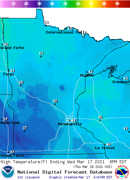
While that puts northern Minnesota above average, it keeps southern Minnesota fairly seasonable for St. Patrick’s Day.
Warming weather
Drier air and more sunshine return throughout the state already Thursday, helping to push highs into the mid-40s to low 50s.
By Friday, most of the state except for the Arrowhead in the 40s, will make it back into the 50s.
This returns Minnesota to our trend of a very warm March. For example, the Twin Cities through the first half of March is running almost 9 degrees above average because of the mild weather.
Those above average 50s persist through at least Sunday. Here is that forecast for the Twin Cities:
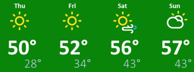
Temperatures likely turn slightly more seasonably cool early next week as clouds and precipitation chances return.
Needed rain
By Sunday more clouds return and chances for rain return. The pattern currently appears the most active Monday through Wednesday, with periods of rain and snow looking probable. Rain is likely to be more predominant, with snow mixing in during the cooler overnight hours.
This could be a needed, soaking rain, especially for southern Minnesota, where some weather models project over an inch of rain from Monday to Wednesday.
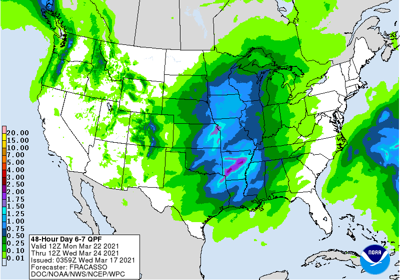
We will keep you posted as next week approaches, but any precipitation would be very beneficial as Minnesota is currently running drier than average.
Programming note
You can hear my live weather updates on Minnesota Public Radio at 7:49 a.m. Monday through Friday morning.

