
Windy and warmer Monday; sharply colder Tuesday
Red flag warning for parts of Minnesota Monday
Go Deeper.
Create an account or log in to save stories.
Like this?
Thanks for liking this story! We have added it to a list of your favorite stories.


Buckle up, temps and winds will be rising sharply on Monday.
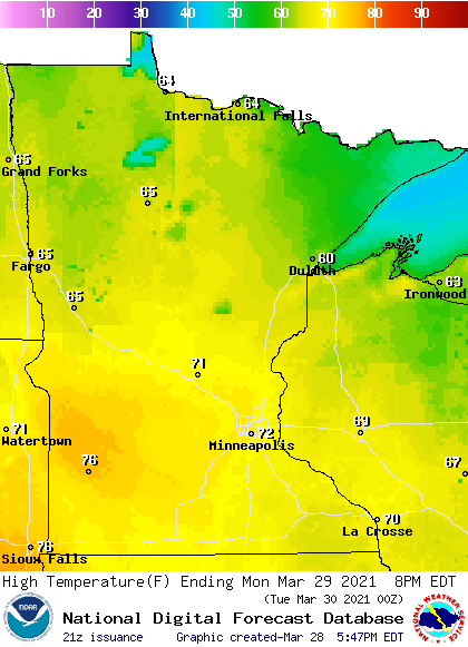
A low pressure system will move toward us on Monday, with a tight pressure gradient out ahead of it. Strong southerly winds and plenty of sunshine will allow temps to reach the 70s in roughly the southern half of Minnesota Monday afternoon:
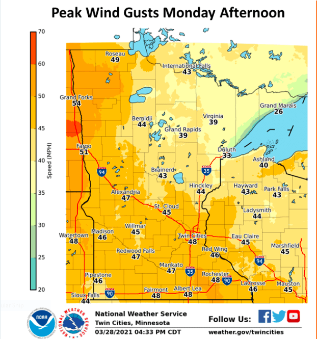
Peak wind gusts of 40 to 50 mph are forecast for Monday:
Wind advisories cover much of southern and central Minnesota, plus northwestern Minnesota and west-central Wisconsin, Monday afternoon and evening. Here are details of the wind advisory that runs from noon to 9 p.m. Monday and includes the Twin Cities metro area:
Turn Up Your Support
MPR News helps you turn down the noise and build shared understanding. Turn up your support for this public resource and keep trusted journalism accessible to all.
URGENT - WEATHER MESSAGE National Weather Service Twin Cities/Chanhassen MN 237 PM CDT Sun Mar 28 2021 MNZ041>045-047>070-073>078-082>085-091>093-WIZ014>016-023>028- 290900- /O.NEW.KMPX.WI.Y.0004.210329T1700Z-210330T0200Z/ Douglas-Todd-Morrison-Mille Lacs-Kanabec-Stevens-Pope-Stearns- Benton-Sherburne-Isanti-Chisago-Lac Qui Parle-Swift-Chippewa- Kandiyohi-Meeker-Wright-Hennepin-Anoka-Ramsey-Washington- Yellow Medicine-Renville-McLeod-Sibley-Carver-Scott-Dakota- Redwood-Brown-Nicollet-Le Sueur-Rice-Goodhue-Watonwan-Blue Earth- Waseca-Steele-Martin-Faribault-Freeborn-Polk-Barron-Rusk- St. Croix-Pierce-Dunn-Pepin-Eau Claire- Including the cities of Alexandria, Long Prairie, Little Falls, Princeton, Mora, Morris, Glenwood, St Cloud, Sauk Rapids, Elk River, Cambridge, Center City, Madison, Benson, Montevideo, Willmar, Litchfield, Monticello, Minneapolis, Blaine, St Paul, Stillwater, Granite Falls, Olivia, Hutchinson, Gaylord, Chanhassen, Chaska, Victoria, Shakopee, Hastings, Redwood Falls, New Ulm, St Peter, Le Sueur, Faribault, Red Wing, St James, Mankato, Waseca, Owatonna, Fairmont, Blue Earth, Albert Lea, Osceola, Rice Lake, Ladysmith, Hudson, River Falls, Menomonie, Durand, Chippewa Falls, and Eau Claire 237 PM CDT Sun Mar 28 2021 ...WIND ADVISORY IN EFFECT FROM NOON TO 9 PM CDT MONDAY... * WHAT...Southwest winds 20 to 30 mph with gusts up to 50 mph expected. * WHERE...Portions of northwest and west central Wisconsin and central, east central, south central, southeast, southwest and west central Minnesota. * WHEN...From noon to 9 PM CDT Monday. * IMPACTS...Gusty winds could blow around unsecured objects. Tree limbs could be blown down and a few power outages may result. PRECAUTIONARY/PREPAREDNESS ACTIONS... Use extra caution when driving, especially if operating a high profile vehicle. Secure outdoor objects.
A wind advisory starts at 3 p.m. Monday in portions of northwestern Minnesota.
You can hear updated weather information for Minnesota and western Wisconsin on the MPR network, and you’ll see updated weather info on the MPR News live weather blog.
Red flag warning Monday in western and north-central Minnesota
Warm temps, strong winds and low relative humidity levels will increase the wildfire danger on Monday. There’s a red flag warning Monday afternoon and evening for most of western Minnesota plus north-central Minnesota:
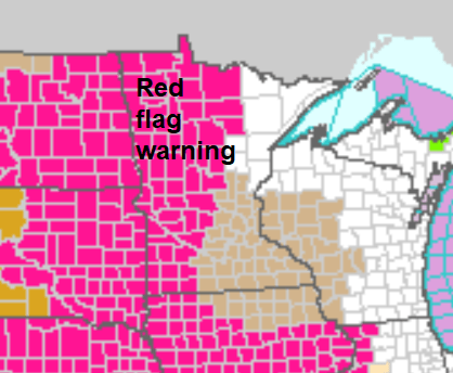
Here are details of the red flag warning to the west:
URGENT - FIRE WEATHER MESSAGE National Weather Service Twin Cities/Chanhassen MN 233 PM CDT Sun Mar 28 2021 ...CRITICAL FIRE WEATHER CONDITIONS EXPECTED MONDAY AFTERNOON AND EVENING ACROSS WESTERN AND PORTIONS OF CENTRAL MINNESOTA... .South winds will increase to 25 to 30 mph with gusts to 40 or 50 mph Monday afternoon, then shift to the west and diminish some Monday evening. Relative humidities will drop to between 20 and 25 percent across western Minnesota by afternoon. A dryline may precede the cold front by a couple hours in the late afternoon. During that time, RH values could drop further into the teens across far western Minnesota. Humidities will improve slowly Monday evening, but winds will remain gusty through the night. MNZ041>043-047>049-054>058-064-065-073-290345- /O.NEW.KMPX.FW.W.0001.210329T1700Z-210330T0600Z/ Douglas-Todd-Morrison-Stevens-Pope-Stearns-Lac Qui Parle-Swift- Chippewa-Kandiyohi-Meeker-Yellow Medicine-Renville-Redwood- 233 PM CDT Sun Mar 28 2021 ...RED FLAG WARNING IN EFFECT FROM NOON MONDAY TO 1 AM CDT TUESDAY FOR STRONG WINDS AND LOW RELATIVE HUMIDITY FOR WESTERN AND PORTIONS OF CENTRAL MINNESOTA... The National Weather Service in Twin Cities/Chanhassen has issued a Red Flag Warning, which is in effect from noon Monday to 1 AM CDT Tuesday. * AFFECTED AREA...West of a line from Little Falls to Litchfield and Redwood Falls. * WIND...South wind 25 to 30 mph with gusts of 45 to 50 mph, becoming west in the evening. * HUMIDITY...17 to 25 percent. * IMPACTS...Any fires that develop will likely spread rapidly. Outdoor burning is not recommended. PRECAUTIONARY/PREPAREDNESS ACTIONS... A Red Flag Warning means that critical fire weather conditions are either occurring now....or will shortly. A combination of strong winds...low relative humidity...and warm temperatures can contribute to extreme fire behavior.
Monday night shower chance
An advancing cold front could generate scattered showers Monday night and early Tuesday. The National Oceanic and Atmospheric Administration’s North American Mesoscale (NAM) forecast model shows the potential precipitation pattern for Monday evening through Tuesday morning:
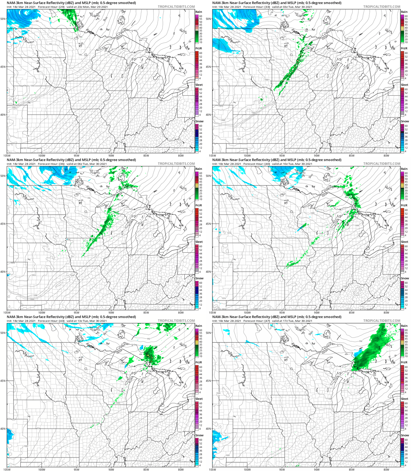
There could even be a few flakes in some areas late Monday night and early Tuesday morning. By the way, Tuesday will be another windy day.
Temperature trends
Twin Cities metro area highs are projected to be in the mid 40s Tuesday and lower 40s on Wednesday. Then temps rebound …we’ll top out around 50 degrees on Thursday, followed by lower 60s Friday. Highs in the 60s are possible next weekend too, and the following week also looks warmer than normal. The NWS Climate Prediction Center shows a strong tendency for above-normal temps in Minnesota and Wisconsin from April 5 through April 11:
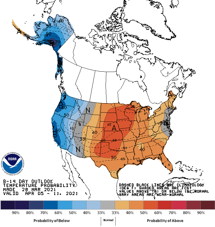
That looks very springy to me!
Programming note
You can hear my live weather updates on MPR News at 7:35 a.m., 9:35 a.m. and 4:39 p.m. each Saturday and Sunday.

