
More record warmth Monday
Severe weather is likely during the evening
Go Deeper.
Create an account or log in to save stories.
Like this?
Thanks for liking this story! We have added it to a list of your favorite stories.


Monday is likely to bring portions of Minnesota record warmth, followed by strong storms.
Monday’s forecast
Following the very warm weather Sunday, where most of the state made it into the 70s, Minnesota is off to a mild start Monday, from a few 30s north to widespread 50s south.
Much of Minnesota just missed record highs on Sunday, although a couple spots broke records, such as Rochester, which at 81 Sunday beat the previous April 4 record of 77.
With forecast highs ranging from 60s and 70s north to 80s south, more record highs are likely to be set on Monday, especially in southern Minnesota.
Turn Up Your Support
MPR News helps you turn down the noise and build shared understanding. Turn up your support for this public resource and keep trusted journalism accessible to all.
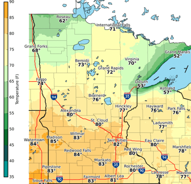
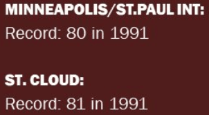
This includes the Twin Cities, where the current April 5 record is 80.
By evening, the same storm that funneled in the warmer air starts pushing a cold front across the state. This brings showers, storms, and even a severe weather risk from Monday evening into he early overnight period. Especially in southwestern through central Minnesota, there may damaging winds and large hail with some of the thunderstorms.

While those storms end overnight, wet weather dominates the forecast for the rest of the week. That extended forecast will be updated around 9 a.m.
Programming note
You can hear my live weather updates on Minnesota Public Radio at 7:49 a.m. Monday through Friday morning.

