
Rain spreads across Minnesota Tuesday
Record warmth ends as clouds and precipitation return
Go Deeper.
Create an account or log in to save stories.
Like this?
Thanks for liking this story! We have added it to a list of your favorite stories.


While still mild, temperatures Tuesday will be noticeably cooler than Monday as clouds and rain make their way across the state.
Tuesday’s forecast
Following another day of record-setting warmth on Monday, Tuesday is starting mild despite a cold front that passed though the state overnight. Morning lows range from 30s north to 50s south.
Although much of Minnesota is starting the day under some sunshine, clouds increase through the day and the majority of the state will see mostly cloudy skies by the afternoon.
This is ahead of a storm system that also starts moving rain in from the south. The southern edge of Minnesota could see spotty showers anytime during the morning, and that chance spreads into central Minnesota Tuesday afternoon. By evening, rain impacts all but northern Minnesota, and heavier rain bands and a few thunderstorms become more likely.
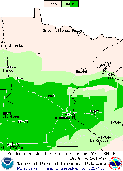
The combination of the cooler air that already moved in, plus clouds and moisture put highs across most of the state in the 50s, although southeastern Minnesota could still see a few 70s.

Rain spreads across northern Minnesota overnight, and by Wednesday, the state is under a soaking rain with wet weather persisting through the end of the week. That extended forecast will be updated around 9 a.m.
Programming note
You can hear my live weather updates on Minnesota Public Radio at 7:49 a.m. Monday through Friday morning.
Turn Up Your Support
MPR News helps you turn down the noise and build shared understanding. Turn up your support for this public resource and keep trusted journalism accessible to all.

