
Weekend forecast: Cool temps, shower chance on Sunday
Flakes possible Northeastern Minn. Saturday morning
Go Deeper.
Create an account or log in to save stories.
Like this?
Thanks for liking this story! We have added it to a list of your favorite stories.


I’ll get to the weekend forecast shortly, but I first want to mention the critical fire weather conditions and red flag warning in northwestern Minnesota Thursday afternoon and evening. The warning covers the red-shaded area on this map:
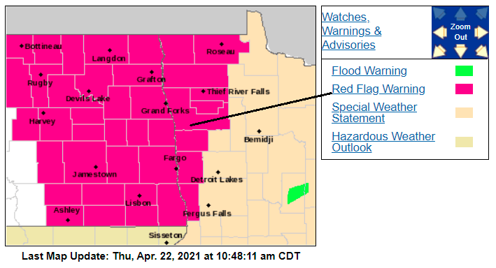
Here are details on the red flag warning:
URGENT - FIRE WEATHER MESSAGE National Weather Service Grand Forks ND 354 AM CDT Thu Apr 22 2021 MNZ001>005-007-008-013>015-029-NDZ006>008-014>016-024-026>030-038- 039-049-052>054-230100- /O.UPG.KFGF.FW.A.0003.210422T1700Z-210423T0100Z/ /O.NEW.KFGF.FW.W.0005.210422T1700Z-210423T0100Z/ West Polk-Norman-Clay-Kittson-Roseau-West Marshall-East Marshall- Pennington-Red Lake-East Polk-Wilkin-Towner-Cavalier-Pembina- Benson-Ramsey-Eastern Walsh-Eddy-Nelson-Grand Forks-Griggs-Steele- Traill-Barnes-Cass-Ransom-Sargent-Richland-Western Walsh- 354 AM CDT Thu Apr 22 2021 ...RED FLAG WARNING IN EFFECT FROM NOON TODAY TO 8 PM CDT THIS EVENING FOR LOW RELATIVE HUMIDITY AND GUSTY WINDS FOR EASTERN NORTH DAKOTA AND PORTIONS OF NORTHWESTERN AND WEST CENTRAL MINNESOTA... The National Weather Service in Grand Forks has issued a Red Flag Warning for low relative humidity and gusty winds, which is in effect from noon today to 8 PM CDT this evening. The Fire Weather Watch is no longer in effect. * AFFECTED AREA...In Minnesota...Fire Weather Zones 001...002... 003...004...005...007...008...013...014...015 and 029. In North Dakota...Fire Weather Zones 006...007...008...014... 015...016... 024...026...027...028...029...030...038...039... 049...052... 053 and 054. * TIMING... Afternoon and early evening Thursday * WINDS...Southwest 15 to 25 mph with gusts up to 35 mph. * RELATIVE HUMIDITY...As low as 13 percent. * TEMPERATURES...In the low to mid 60s. PRECAUTIONARY/PREPAREDNESS ACTIONS... A Red Flag Warning means that critical fire weather conditions are either occurring now, or will shortly. A combination of strong winds, low relative humidity, and warm temperatures can contribute to extreme fire behavior.
Most of the remainder of Minnesota, and western Wisconsin, have elevated fire weather conditions Thursday afternoon and evening. Here are the details:
Turn Up Your Support
MPR News helps you turn down the noise and build shared understanding. Turn up your support for this public resource and keep trusted journalism accessible to all.
Special Weather Statement National Weather Service Twin Cities/Chanhassen MN 432 AM CDT Thu Apr 22 2021 MNZ041>045-047>070-073>078-082>085-091>093-WIZ014>016-023>028- 222345- Douglas-Todd-Morrison-Mille Lacs-Kanabec-Stevens-Pope-Stearns- Benton-Sherburne-Isanti-Chisago-Lac Qui Parle-Swift-Chippewa- Kandiyohi-Meeker-Wright-Hennepin-Anoka-Ramsey-Washington- Yellow Medicine-Renville-McLeod-Sibley-Carver-Scott-Dakota- Redwood-Brown-Nicollet-Le Sueur-Rice-Goodhue-Watonwan-Blue Earth- Waseca-Steele-Martin-Faribault-Freeborn-Polk-Barron-Rusk- St. Croix-Pierce-Dunn-Pepin-Eau Claire- Including the cities of Alexandria, Long Prairie, Little Falls, Princeton, Mora, Morris, Glenwood, St Cloud, Sauk Rapids, Elk River, Cambridge, Center City, Madison, Benson, Montevideo, Willmar, Litchfield, Monticello, Minneapolis, Blaine, St Paul, Stillwater, Granite Falls, Olivia, Hutchinson, Gaylord, Chanhassen, Chaska, Victoria, Shakopee, Hastings, Redwood Falls, New Ulm, St Peter, Le Sueur, Faribault, Red Wing, St James, Mankato, Waseca, Owatonna, Fairmont, Blue Earth, Albert Lea, Osceola, Rice Lake, Ladysmith, Hudson, River Falls, Menomonie, Durand, Chippewa Falls, and Eau Claire 432 AM CDT Thu Apr 22 2021 ...ELEVATED FIRE WEATHER CONDITIONS TODAY... Relative humidity values dropping to between 15 and 25 percent along with west-southwest winds between 10 and 20 mph will result in elevated fire weather conditions today. Check with the DNR or your county for any burning restrictions before doing any outdoor burning. Use caution with off-road vehicles or equipment that can create a spark and start a fire. Extinguish and dispose of cigarettes properly.
Minnesota Department of Natural Resources fire danger and burning restrictions maps can be found here.
You can hear updated weather information for Minnesota and western Wisconsin on the MPR network, and you’ll see updated weather info on the MPR News live weather blog.
Weekend temps and winds
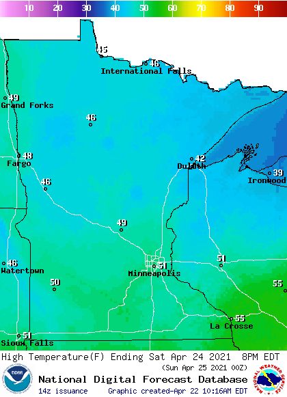
Our average Twin Cities high temperature on April 24 is 62 degrees. The metro area, southern Minnesota and western Wisconsin may top out in the lower 50s this Saturday, with 40s in northern and central Minnesota:
Saturday wind gusts will be in the 16-22 mph range in most areas:
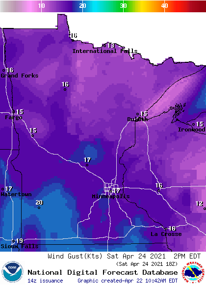
Plotted gusts are in knots, with 17 knots equal to 19.6 mph.
Back to temperatures, Sunday highs will be mainly in the 40s in northern and central Minnesota, with 50s in the far south:
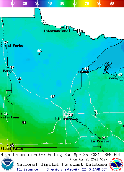
We could touch 50 degrees in the Twin Cities.
Sunday will be breezy in western Minnesota, with lighter winds in eastern Minnesota.
Rain and snow chances?
Northeastern Minnesota and northwestern Wisconsin have the best chance of snow showers Saturday morning. A stray flurry cannot be ruled out in the metro area Saturday morning.
Periods of snow showers are possible Sunday morning, then some locations could see a mix of rain showers and snow showers Sunday afternoon and evening. The National Oceanic and Atmospheric Administration’s Global Forecast System (GFS) model shows the potential precipitation pattern Sunday and Sunday evening:

Check forecast updates.
Programming note
You can hear my live weather updates on MPR News at 7:35 a.m., 9:35 a.m. and 4:39 p.m. each Saturday and Sunday.

