
Statewide sunshine returns Wednesday
Dense morning fog in portions of central and northern Minnesota
Go Deeper.
Create an account or log in to save stories.
Like this?
Thanks for liking this story! We have added it to a list of your favorite stories.


After Minnesota breaks out of widespread morning fog, the return of more sunshine will help push most of the state back into the 60s and even 70s by the afternoon.
Wednesday’s forecast
The stationary front that has plagued Minnesota, especially the southern half of the state, with more clouds and rain the past few days has finally dipped farther south. Southern Minnesota sees a few more clouds during the morning, and maybe an isolated sprinkle, but more sunshine finally returns by the afternoon.
Cleared skies are already present in northern and central Minnesota, but with the recent moisture and clear skies overnight, areas of widespread fog developed.
The fog lifts through the morning, then sunny skies prevail. There are also a few patches of fog along the southern edge of the state, although it will still be cloudier much of the morning there even after the fog dissipates.
Turn Up Your Support
MPR News helps you turn down the noise and build shared understanding. Turn up your support for this public resource and keep trusted journalism accessible to all.
Because of the clear skies in northern and central Minnesota, morning temperatures dropped into the 30s and 20s, while the southern edge of the state stayed in the upper 30s and low 40s thanks to more cloud cover.
The reverse pattern happens in the afternoon, where because clouds linger longer, southern Minnesota only makes it into the lower 60s. Northern Minnesota sees more sun, plus the northwestern corner of the state gets a southerly flow ahead of a cold front, which could push a few temperatures into the 70s.
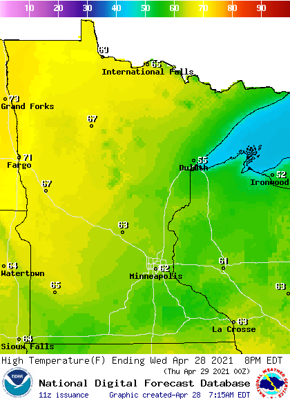
That cold front moves through overnight, bringing light rain and a slightly cooler Thursday, but temperatures rebound significantly by the weekend. That extended forecast will be updated around 9:30 a.m.
Programming note
You can hear my live weather updates on Minnesota Public Radio at 7:49 a.m. Monday through Friday.

