
New climate normals show Minnesota turning warmer
The week ahead stays cooler and drier

Go Deeper.
Create an account or log in to save stories.
Like this?
Thanks for liking this story! We have added it to a list of your favorite stories.


In contrast with the cooler and drier forecast for the next week, Minnesota is turning warmer and wetter overall based on trends shown by our new 30-year averages.
When you hear MPR News meteorologists talk about “normals” (for example, the normal high for the Twin Cities May 5 is 65 degrees), it is based on 30 years of compiled data that is recalculated every decade.
The update that included the decade of 2011 to 2020 was just published Tuesday, so now the normals go from a period of 1991 to 2020 versus the previous normals which used data that went from 1981 to 2010.
Updating the data reveals some noticeable trends across our state and the country. Temperatures across most of the country, including Minnesota, continue to trend warmer.
Turn Up Your Support
MPR News helps you turn down the noise and build shared understanding. Turn up your support for this public resource and keep trusted journalism accessible to all.
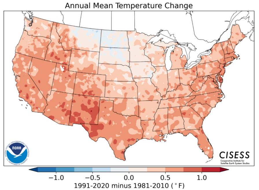
Only an area near the northern Great Plains and a few spots in the northern Midwest, including a small section of Minnesota’s western border, were slightly cooler.
For precipitation, there were noticeably wetter and drier regions across the United States, with the southwest being much drier and most of the East Coast turning wetter.
In Minnesota, the trend is predominantly wetter, but there were a few drier pockets, including in northern Minnesota.
More details about the new climate normals can be found on the National Oceanic and Atmospheric Administration website.
Wednesday’s forecast
As expected, Minnesota woke up on the chilly side Wednesday morning, with lows in the 20s and 30s. That meant frost for much of the state. Daytime temperatures also run about 10 degrees below average for most of the state, with highs in the 50s.

Especially for southern Minnesota, this is a few degrees cooler than Tuesday, which is due in part to less sunshine.
Clouds spread across the southern half of Minnesota through the morning, leading to a cloudy afternoon.

This is caused by a storm that will slide south of the state. That system also brings light rain chances which are highest for the southern edge of the state, then diminish as you head north, with the rain likely to miss northern Minnesota.
For the Twin Cities, the timing for a couple light showers is most likely from the midafternoon into the evening.
Staying cooler
Following the cooler weather Wednesday, Thursday morning will start chilly again, with more 20s and 30s and a widespread frost potential again.
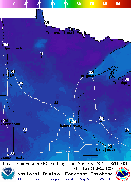
Although subsequent mornings may not be as chilly, below average highs are likely to continue for much of the next week, with most of Minnesota seeing afternoon temperatures in the 50s, with occasional low 60s south.
Here is that forecast for the Twin Cities through Friday:
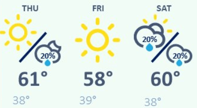
Meanwhile, precipitation chances stay slim, with a minor disturbance that could create a couple isolated showers Thursday afternoon and evening.
Another storm brings light precipitation to Minnesota over the weekend, but it looks like the brunt of that system should stay south of the state.
Programming note
You can hear my live weather updates on Minnesota Public Radio at 7:49 a.m. Monday through Friday morning.

