
After a mostly dry May, Minnesota weather turns soggy
Temperatures stay above average with a few 90s possible Saturday
Go Deeper.
Create an account or log in to save stories.
Like this?
Thanks for liking this story! We have added it to a list of your favorite stories.


A broad flow of moisture starts funneling into Minnesota Wednesday, bringing higher humidity, periods of rain and storms and above average temperatures through early next week.
Wednesday’s forecast
Thanks to mostly cloudy skies and a southerly flow, Minnesota stayed very warm overnight with most of the state waking up in the 60s. This was 10 to 20 degrees above average low temperatures.
Highs will also be slightly above average, although cloud cover and moisture keep the state from warming too much. Most places will see 70s, except northwestern Minnesota is likely to get more sunshine and make it into the 80s.
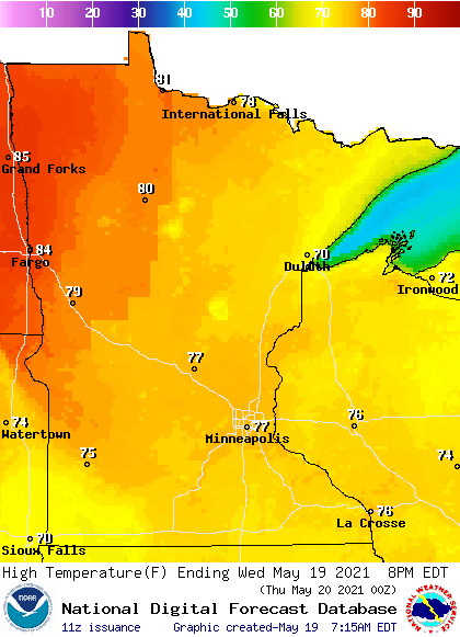
The southerly flow is already bringing enough moisture for widespread morning fog in central and southern Minnesota, and there are a few spotty showers along the eastern edge of the state as of 9:30 a.m.
Turn Up Your Support
MPR News helps you turn down the noise and build shared understanding. Turn up your support for this public resource and keep trusted journalism accessible to all.
Although the fog lifts through the morning, it stays noticeably more humid throughout the day. Showers spread across the state by the afternoon with isolated storms at times.
Thursday’s forecast
The pattern shift causing the wet change for Minnesota is a southerly flow tapping moisture all the way from the Gulf of Mexico. This flow really opens up by Wednesday night and Thursday, bringing pretty persistent showers and storms across the state Thursday.
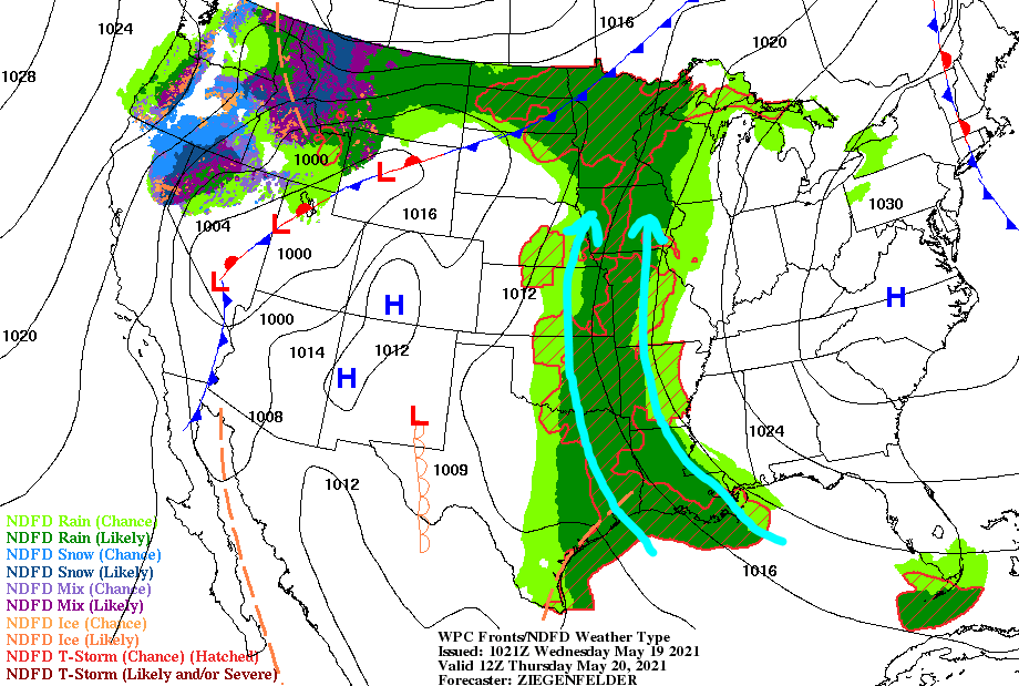
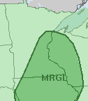
While most of the coming trend is a rain event, on Thursday especially, there could be isolated severe weather with large hail and high winds possible.
Eastern and southern Minnesota are under a “marginal” (isolated) severe weather risk Thursday because of that potential.
Despite all the clouds and rain, highs for most of the state should still make it into the 70s and low 80s.
Extended forecast
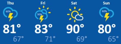
The moisture flow from the Gulf becomes less direct after Thursday, so the wet weather becomes a little less persistent by Friday, with occasional breaks of sunshine likely. That little bit of extra sunshine puts more of Minnesota back into the 80s Friday, and there could be a couple 90s in southern Minnesota by Saturday.
However, the state will still be under a moist southerly flow, so humidity stays higher and scattered showers and occasional storms continue through the weekend. In fact, after a couple more dry and sunny breaks Friday and especially Saturday, Sunday and Monday look likely to turn cloudier and wetter again. The return of more clouds moderate temperatures again by Sunday.
Here is that forecast through Sunday:
Through Monday, much of Minnesota can expect at least an inch of rain, which is tremendously beneficial given Minnesota’s dry spring so far.
It currently looks like the brunt of the wetter pattern should end by Tuesday, with the humidity finally lowering and rain chances becoming spottier again.
Programming note
You can hear my live weather updates on Minnesota Public Radio at 7:49 a.m. Monday through Friday morning.

