
A mix of sunshine and storms Friday
Humidity stays high as more of the state sees 80s again
Go Deeper.
Create an account or log in to save stories.
Like this?
Thanks for liking this story! We have added it to a list of your favorite stories.


More of Minnesota sees dry breaks and periods of sunshine Friday, but a severe weather risk still lingers for some areas.
Friday’s forecast
The recent flow of Gulf of Mexico moisture that has caused the recent rain across Minnesota is a little less direct Friday and has shifted the brunt of the rain east of the state.
However, there are still lingering showers and storms along the eastern edge of Minnesota as of 7 a.m., and eastern Minnesota is likely to keep occasional showers and storms around during the day Friday.

There will also be a separate area of low pressure that brings showers and storms into northern Minnesota by Friday evening.
Turn Up Your Support
MPR News helps you turn down the noise and build shared understanding. Turn up your support for this public resource and keep trusted journalism accessible to all.
With the two areas of moisture, there is a “marginal” (isolated) severe weather risk for both northwestern and southeastern Minnesota Friday. Large hail is the primary threat northwest, and damaging winds with maybe a couple isolated, weak tornadoes are possible southeast.
Despite the areas of active weather, much of Minnesota will see more breaks of sunshine by the afternoon, and that will drive highs into the 80s for most of the state.
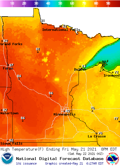
This follows another warm and humid morning, with lows predominantly in the 60s.
Temperatures surge even more Saturday, with highs near 90 possible for some parts of the state, and more storms likely over the weekend. That extended forecast will be updated around 9 a.m.
Programming note
You can hear my live weather updates on Minnesota Public Radio at 7:49 a.m. Monday through Friday morning.

