
Record heat expected by late week
Minnesota stays predominantly dry through the weekend
Go Deeper.
Create an account or log in to save stories.
Like this?
Thanks for liking this story! We have added it to a list of your favorite stories.


Temperatures continues to climb through the end of the week, and with most of Minnesota seeing highs in the 90s by Friday, records could tumble.
Wednesday forecast
With the warming trend Minnesota is under both high and low temperatures will be on the rise. This was already noticeable in the Wednesday morning lows, which were slightly milder than the past few mornings, with temperatures mostly in the 40s and 50s north and 50s and 60s south.
Highs also turn even warmer, and most of the state will be back in the 80s by the afternoon.
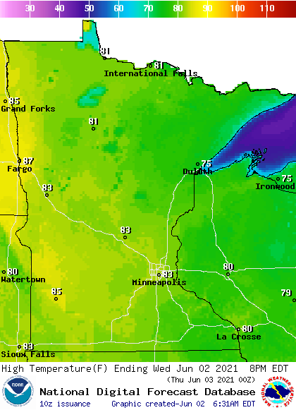
Aiding in the warm weather are mostly sunny skies and winds that start light but become a breezier southwesterly flow by the afternoon.
A minor disturbance is bringing a few showers and isolated storms across central Minnesota Wednesday morning, and additional spotty activity could develop in northern and central Minnesota during the afternoon.
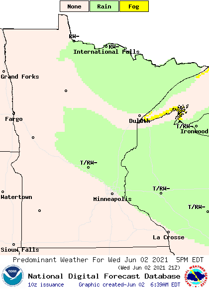
This wet weather stays limited in part because the air is so dry, so some of the moisture is evaporating before even making it to the ground.
Turn Up Your Support
MPR News helps you turn down the noise and build shared understanding. Turn up your support for this public resource and keep trusted journalism accessible to all.
From warm to hot
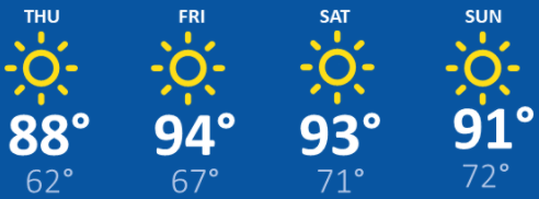
Temperatures continue to surge the rest of the week, with most of the state in the 90s by Friday and through the weekend.
Overnight lows also warm, with the majority of the state seeing lows in the 60s or warmer Friday morning, then overnight lows near or in the 70s for much of the state over the weekend.
Here is that forecast for the Twin Cities through Sunday:
The hot days and warm overnights mean little relief from the heat, so be careful to prevent heat illness if you are outside for extended periods or have housing without air conditioning.
The humidity will also slowly rise by the weekend, making the weekend weather both hot and sticky.
It currently looks like the 90s break after Monday, with more 80s next week, but that will still be above average.
Meanwhile, rain chances stay slim. There could still be a couple very isolated showers or storms Thursday, especially in northern Minnesota, but no major storms or soaking rain is forecast through the end of the week. Mostly sunny skies dominate our upcoming weather.
This predominantly dry trend plus hotter temperatures is likely to raise the fire risk again by Friday, particularly in northern Minnesota where May was very dry. This includes the Fargo and Moorhead area, which is coming off of a record dry May.
Programming note
You can hear my live weather updates on Minnesota Public Radio at 7:49 a.m. Monday through Friday morning.

