
Thursday severe weather risk highest south; Weekend: Sunday thunder chance
Minnesota drought conditions update
Go Deeper.
Create an account or log in to save stories.
Like this?
Thanks for liking this story! We have added it to a list of your favorite stories.


Numerous showers and thunderstorms could develop in southern Minnesota and southern and central Wisconsin as we go through Thursday afternoon and into Thursday evening. Scattered showers and thunderstorms are possible in central Minnesota and west-central Wisconsin this afternoon and evening.
The National Weather Service Storm Prediction Center shows an enhanced risk (shaded orange) of severe weather Thursday afternoon into Thursday night in far southern Minnesota and southwestern Wisconsin, with a slight risk of severe weather (shaded yellow) in adjacent areas of southern Minnesota and southern Wisconsin:
Here’s the severe weather discussion from the NWS earlier today, before the enhanced risk area was expanded to cover more of southeastern Minnesota:
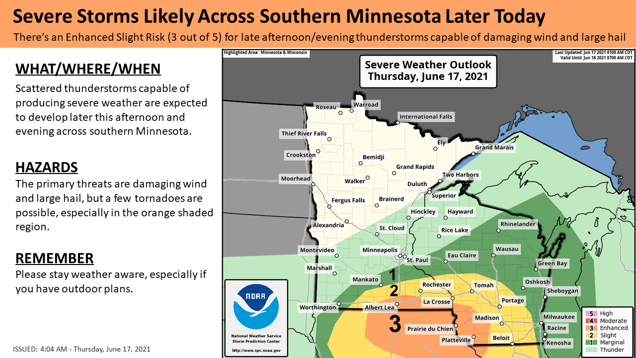
The southern portion of the Twin Cities metro area is in the SPC marginal risk category Thursday afternoon and evening, which means that an isolated severe thunderstorm is possible. Here are the severe weather risk categories that are used by the NWS Storm Prediction Center:
Turn Up Your Support
MPR News helps you turn down the noise and build shared understanding. Turn up your support for this public resource and keep trusted journalism accessible to all.

The Storm Prediction Center updates their severe weather outlook every few hours. Stay weather aware this Thursday afternoon and evening.
You can hear updated weather information for Minnesota and western Wisconsin on the Minnesota Public Radio network, and you can see updated weather info on the MPR News live weather blog.
Drought update
The weekly drought update from U.S. Drought Monitor shows moderate drought (shaded beige) in much of western and southern Minnesota, plus parts of central Minnesota and the southern half of the Twin Cities metro area:

The orange-shaded areas in far southern Minnesota and parts of the northwest are in severe drought. The counties shaded yellow are abnormally dry, but not yet in drought, according to U.S. Drought Monitor.
Weekend forecast
Saturday looks like the driest day of the weekend. Temps will be slightly above normal in most areas this weekend.
Saturday highs will be in the 80s in central and southern Minnesota plus western Wisconsin:
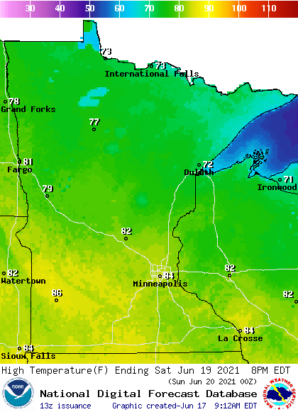
Northern Minnesota will see mainly 70s, but a few spots up along the North Shore of Lake Superior could top out in the 60s.
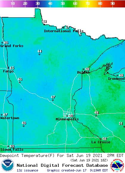
Saturday dew points will be in the very comfortable 40s and lower 50s:
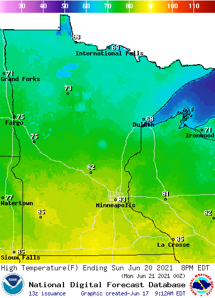
Sunday highs will range from the 80s in southern and central Minnesota to the upper 60s in far northern Minnesota:
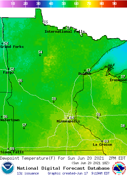
Sunday dew points will be in the sticky 60s from the Twin Cities metro area into southeastern Minnesota and southwestern Wisconsin, with 50s elsewhere:
Rain opportunities on Father’s Day
Periods of rain and a few embedded thunderstorms are expected late Saturday night and also on Sunday. We’re expecting some dry hours too, but have a plan “B” if you have outdoor activities scheduled this Sunday.
NOAA’s Global Forecast System (GFS) model may be overdoing the rain coverage a bit, but it shows many areas receiving periods of rain as we go from Saturday night through Sunday afternoon:
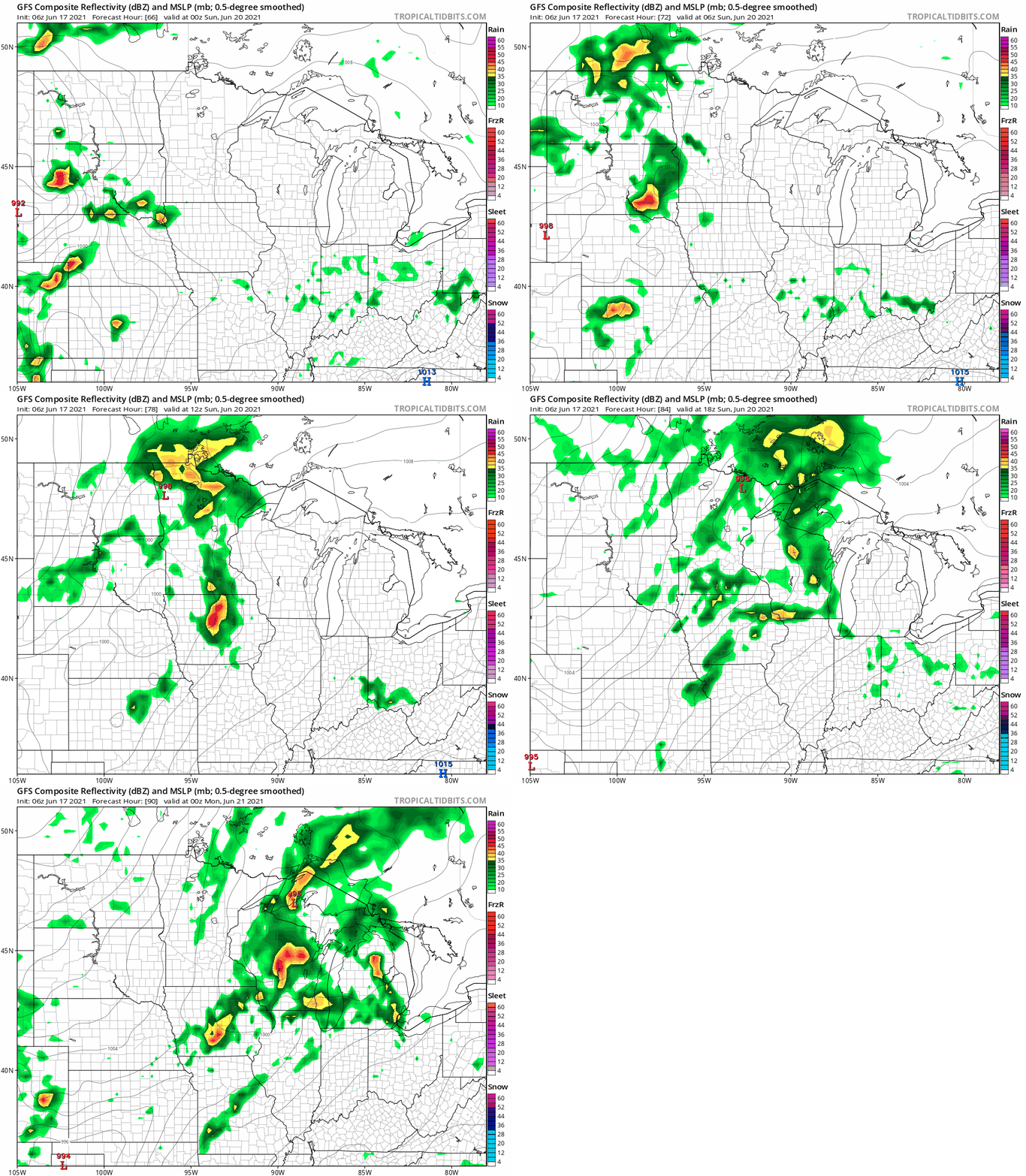
We’ll have a better idea on Sunday rain coverage in the next couple of days. Check forecast updates.
Programming note
You can hear my live weather updates on MPR News at 7:35 a.m., 9:35 a.m. and 4:39 p.m. each Saturday and Sunday.

