
Lots of 90s this holiday weekend; drought update
Go Deeper.
Create an account or log in to save stories.
Like this?
Thanks for liking this story! We have added it to a list of your favorite stories.


You expect warm weather on the Fourth of July holiday weekend, and that’s exactly what’s on tap.
This holiday weekend begins on Friday for many people. Friday will be a nice, summery day, with plenty of sunshine and scattered fair-weather cumulus clouds popping up by afternoon. A few spots in western Minnesota could top 90 degrees Friday afternoon, with mainly 80s elsewhere:
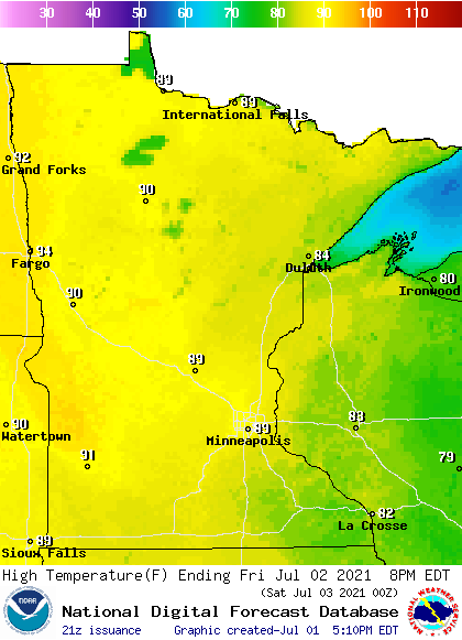
A lot of 90s Saturday and Sunday
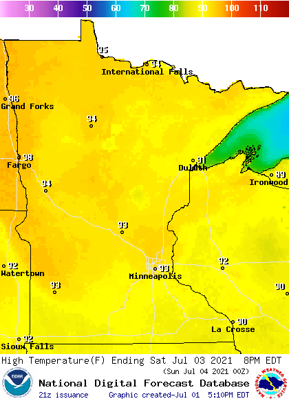
Highs reach the 90s in most locations on Saturday:
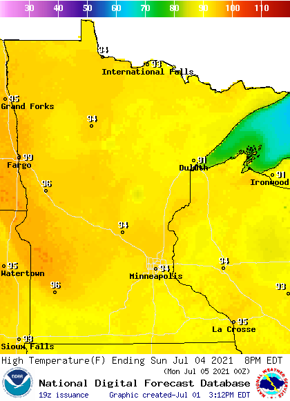
Most spots will also reach the 90s on Sunday:
Turn Up Your Support
MPR News helps you turn down the noise and build shared understanding. Turn up your support for this public resource and keep trusted journalism accessible to all.
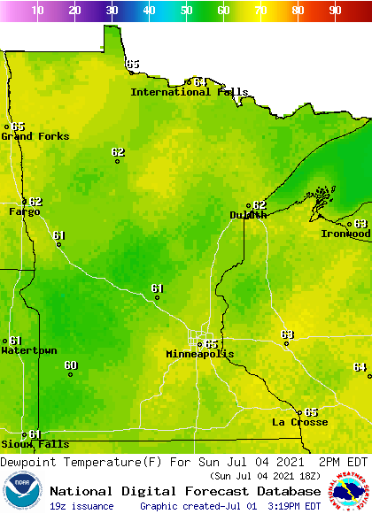
Sunday afternoon dew points will be in the 60s, so it might feel a bit sticky at times:
Monday highs cool to the 80s in the north, with 90s lingering in southern Minnesota:
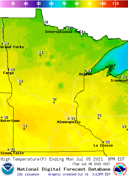
Rain chances?
Friday and Saturday look rain-free in most of Minnesota and western Wisconsin. Northwestern and north-central Minnesota will have a chance of scattered showers and thunderstorms Saturday night and Sunday. That rain chance expands Sunday night into central and southern Minnesota and western Wisconsin. All areas will have a chance of scattered showers and thunderstorms on Monday.
Drought update
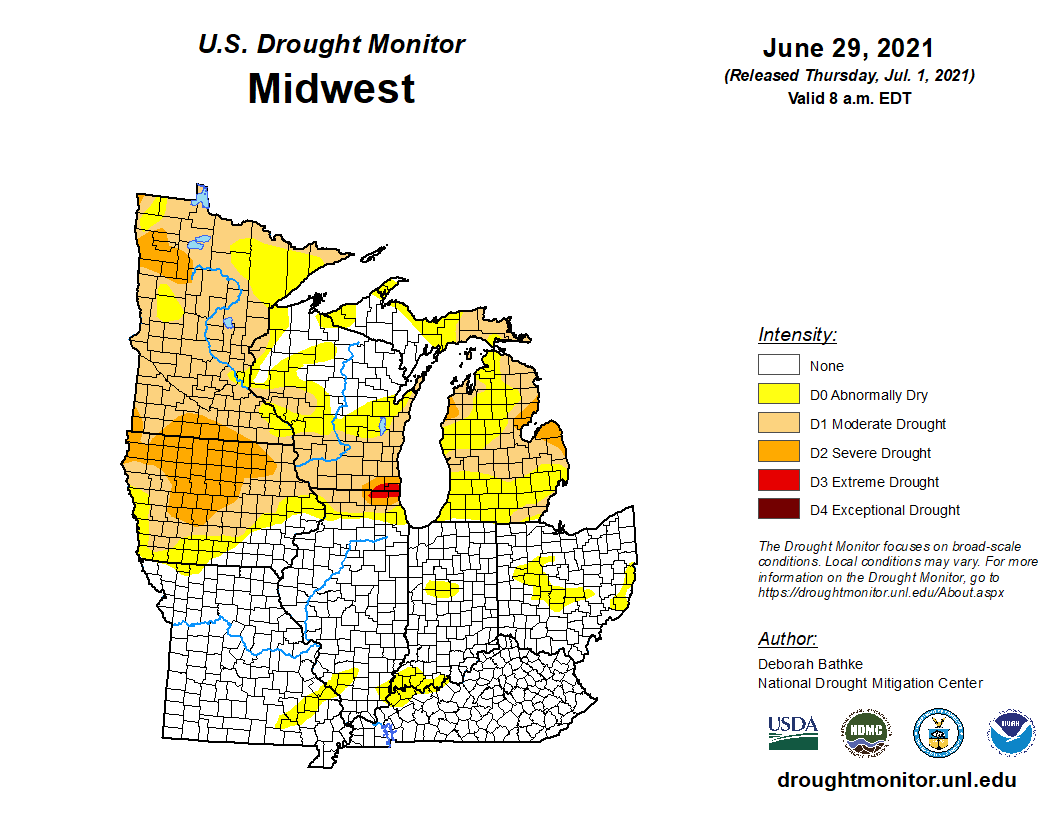
The weekly drought update from the U.S. Drought Monitor shows moderate drought (shaded beige) in much of Minnesota, with areas of severe drought (shaded orange) in parts of far southern Minnesota and a portion of northwestern Minnesota:

The areas that are shaded yellow are abnormally dry, but not yet in drought, according to the U.S. Drought Monitor.
The table to the right of the map shows that 82.14 percent of Minnesota is in drought right now, with abnormally dry conditions elsewhere in Minnesota. One year ago, just 19.21 percent of Minnesota was experiencing drought conditions.
Much of Iowa and southern Wisconsin also have drought conditions right now:
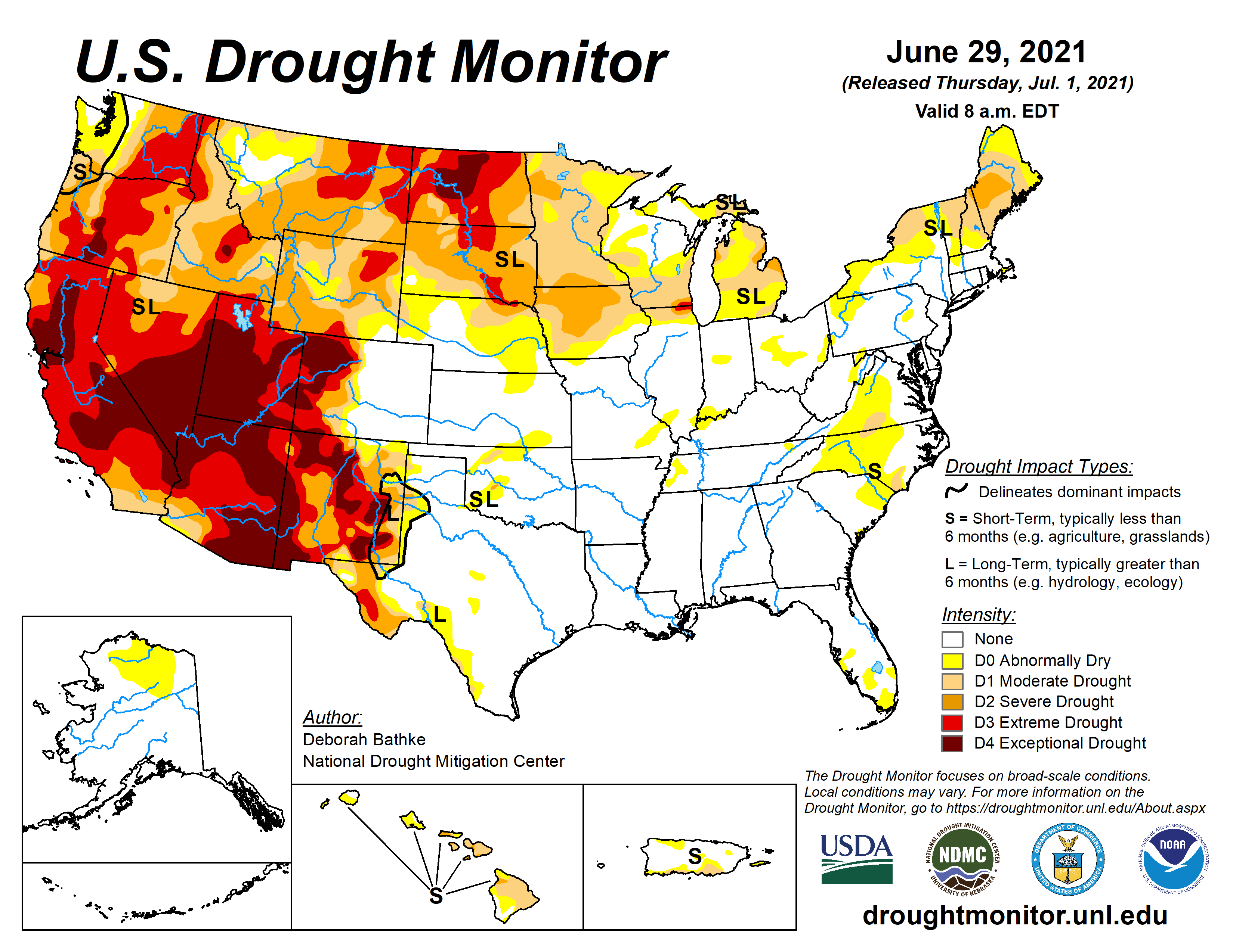
Drought conditions are even worse in portions of North Dakota and South Dakota and in numerous western states:
Tropical storm Elsa
The National Hurricane Center is tracking tropical storm Elsa, which could affect Haiti, the Dominican Republic and Cuba this weekend and portions of Florida early next week. The National Hurricane Center has posted this forecast track for Elsa, along with the cone of uncertainty for that track:
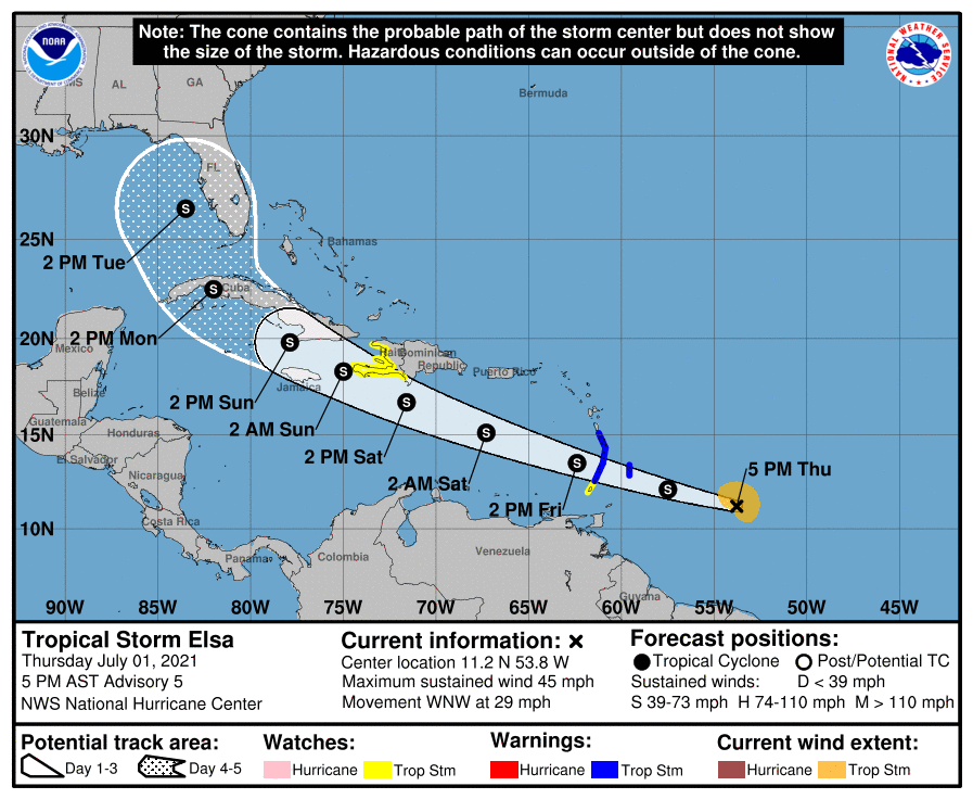
Here’s the Thursday afternoon update on Elsa:
BULLETIN Tropical Storm Elsa Advisory Number 5 NWS National Hurricane Center Miami FL AL052021 500 PM AST Thu Jul 01 2021 ...ELSA STILL MOVING RAPIDLY WEST-NORTHWESTWARD... ...TROPICAL STORM WATCH ISSUED FOR PORTIONS OF HAITI... SUMMARY OF 500 PM AST...2100 UTC...INFORMATION ---------------------------------------------- LOCATION...11.2N 53.8W ABOUT 410 MI...660 KM ESE OF BARBADOS ABOUT 520 MI...835 KM ESE OF ST. VINCENT MAXIMUM SUSTAINED WINDS...45 MPH...75 KM/H PRESENT MOVEMENT...WNW OR 285 DEGREES AT 29 MPH...46 KM/H MINIMUM CENTRAL PRESSURE...1005 MB...29.68 INCHES WATCHES AND WARNINGS -------------------- CHANGES WITH THIS ADVISORY: A Tropical Storm Watch is in effect for the southern and western coasts of Haiti from the southern border of the Dominican Republic to Le Mole le St. Nicholas. SUMMARY OF WATCHES AND WARNINGS IN EFFECT: A Tropical Storm Warning is in effect for... * Barbados * Martinique * St. Lucia * St. Vincent and the Grenadines A Tropical Storm Watch is in effect for... * Grenada and its dependencies * The southern and western coasts of Haiti from the southern border of the Dominican Republic to Le Mole le St. Nicholas A Tropical Storm Warning means that tropical storm conditions are expected somewhere within the warning area within 36 hours. A Tropical Storm Watch means that tropical storm conditions are possible within the watch area, in this case within 36 hours. Interests elsewhere in the Windward Islands, Leeward Islands, the Virgin Islands, Puerto Rico, the Dominican Republic, Haiti, eastern Cuba, and Jamaica should monitor the progress of Elsa. Additional watches and warnings will likely be required later tonight and Friday. For storm information specific to your area, please monitor products issued by your national meteorological service. DISCUSSION AND OUTLOOK ---------------------- At 500 PM AST (2100 UTC), the center of Tropical Storm Elsa was located near latitude 11.2 North, longitude 53.8 West. Elsa is moving toward the west-northwest near 29 mph (46 km/h) and this general motion is expected to continue for the next couple of days. On the forecast track, Elsa will pass near or over portions of the Windward Islands or the southern Leeward Islands on Friday, move into the eastern Caribbean Sea late Friday and Friday night, and move near the southern coast of Hispaniola on Saturday. By Sunday, Elsa is forecast to move near Jamaica and portions of eastern Cuba. Maximum sustained winds are near 45 mph (75 km/h) with higher gusts. Some strengthening is forecast during the next 48 hours. Tropical-storm-force winds extend outward up to 90 miles (150 km) mainly to the north of the center. The estimated minimum central pressure is 1005 mb (29.68 inches). HAZARDS AFFECTING LAND ---------------------- Key messages for Elsa can be found in the Tropical Cyclone Discussion under AWIPS header MIATCDAT5, WMO header WTNT45 KNHC and on the web at www.hurricanes.gov/graphics_at5.shtml?key_messages. WIND: Tropical storm conditions are expected in portions of the Windward and southern Leeward Islands within the warning areas on Friday. Tropical storm conditions are possible in the watch areas in the Lesser Antilles on Friday. Tropical storm conditions are possible in the watch area in Haiti on Saturday. STORM SURGE: A storm surge will raise water levels by as much as 1 to 3 feet above normal tide levels in areas of onshore winds along the southern coast of Hispaniola. RAINFALL: Elsa is expected to produce rainfall totals of 3 to 6 inches with maximum amounts of 10 inches on Friday across the Windward and southern Leeward Islands, including Barbados. This rain may lead to isolated flash flooding and mudslides. Over Puerto Rico, rainfall of 1 to 3 inches with localized amounts of 5 inches is expected Friday into Saturday. This rain may lead to isolated flash flooding and minor river flooding, along with the potential for mudslides. Along portions of southern Hispaniola, rainfall of 4 to 8 inches with isolated maximum amounts of 12 inches is possible on Saturday. This rain may lead to scattered flash flooding and mudslides.
The National Hurricane Center posts updated tropical advisories every three hours or so.
Programming note
You can hear my live weather updates on MPR News at 7:35 a.m., 9:35 a.m. and 4:39 p.m. each Saturday and Sunday.

