
A warm Fourth of July weekend; update on Sunday rain chances
Hurricane Elsa update
Go Deeper.
Create an account or log in to save stories.
Like this?
Thanks for liking this story! We have added it to a list of your favorite stories.


Temperatures will ramp up a bit this Fourth of July holiday weekend.
Our average Twin Cities high temp is 83 degrees this time of year. Many spots in the metro area will top out in the lower 90s Saturday afternoon. Highs in the 90s are expected across most of Minnesota and western Wisconsin this Saturday. There could be some 80s up along the North Shore of Lake Superior. Dew points will be in the comfortable 50s in eastern Minnesota and western Wisconsin, with some 60s in western Minnesota.
Our Saturday sunshine will be filtered at times by smoke from Canadian wildfires. That smoke has recently caused colorful sunrises and sunsets in parts of Minnesota and western Wisconsin:
Most of Minnesota plus western Wisconsin will have a rain-free Saturday. Scattered showers and thunderstorms are possible Saturday evening in northwestern Minnesota. That rain chance spreads into north-central Minnesota overnight Saturday night.
Turn Up Your Support
MPR News helps you turn down the noise and build shared understanding. Turn up your support for this public resource and keep trusted journalism accessible to all.
Sunday rain chances?
There’s a chance of scattered showers and thunderstorms in roughly the northern third of Minnesota Sunday morning, then that rain chance expands into central Minnesota and northwestern Wisconsin Sunday afternoon. Scattered showers and thunderstorms are possible anywhere in Minnesota and western Wisconsin Sunday evening. In the Twin Cities metro area, the chance of scattered showers and t-storms is mainly late Sunday afternoon and Sunday evening/night. Check forecast updates.
The NWS Storm Prediction Center shows a marginal risk of severe weather Sunday and Sunday night for the portions of Minnesota and western Wisconsin that are shaded dark-green on the following image:
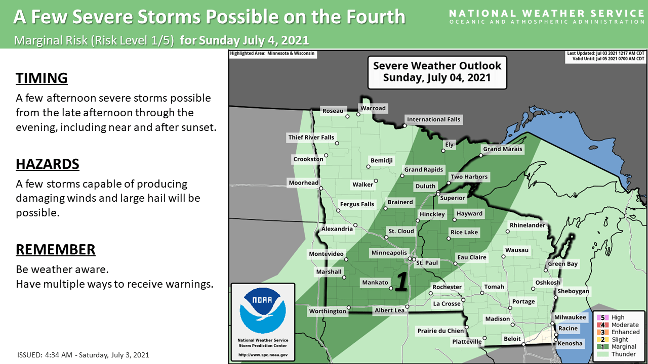
Marginal risk means that an isolated severe thunderstorm is possible.
You can hear updated weather information for Minnesota and western Wisconsin on the Minnesota Public Radio network, and you can see updated weather info on the MPR News live weather blog.
On Monday, there will be a chance of scattered showers and thunderstorms in southeastern Minnesota and southwestern Wisconsin.
Temperature trends
Highs in the 90s are expected in most of Minnesota plus western Wisconsin on Sunday:
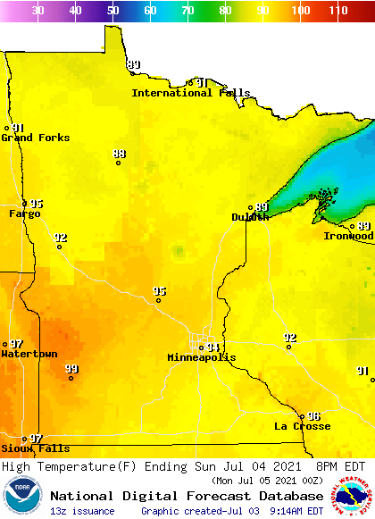
A few spots in west-central and southwestern Minnesota could touch 100. There will be some 80s along the North Shore of Lake Superior.
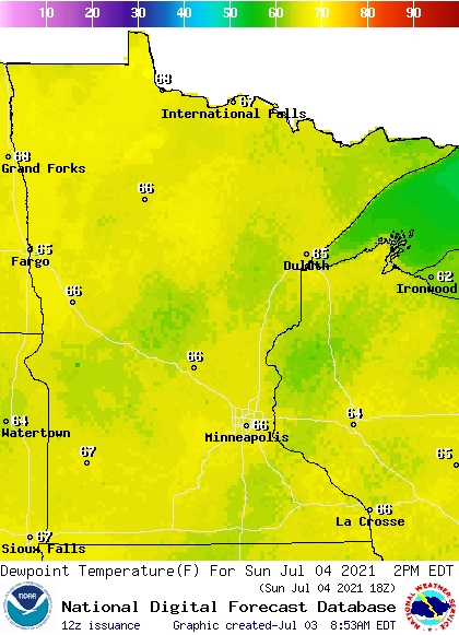
Sunday afternoon dew points rise into the sticky 60s:
Back to high temperatures, northern Minnesota will have Monday highs in the 80s, with 90s to the south:
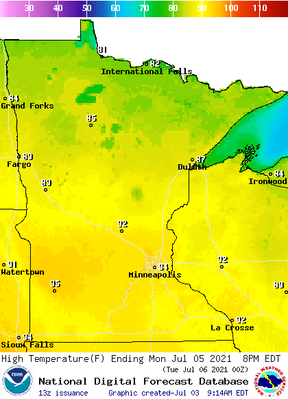
Twin Cities metro area highs are projected to be in the lower 80s Tuesday, followed by upper 70s Wednesday. then lower 80s Thursday and around 90 on Friday.
Elsa update
The sustained winds of Hurricane Elsa have dipped slightly below 74 mph, so Elsa is now a strong tropical storm. Elsa may regain hurricane strength at some point.
The National Hurricane Center is tracking Elsa, which is affecting Haiti, the Dominican Republic and Cuba this weekend and portions of Florida on Monday and Tuesday. The National Hurricane Center has posted this forecast track for Elsa, along with the cone of uncertainty for that track:
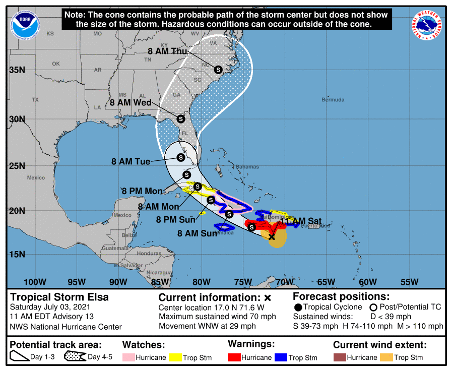
Here’s the Saturday morning update on Elsa:
BULLETIN Tropical Storm Elsa Advisory Number 13 NWS National Hurricane Center Miami FL AL052021 1100 AM EDT Sat Jul 03 2021 ...CONDITIONS CONTINUE TO DETERIORATE OVER PORTIONS OF THE DOMINICAN REPUBLIC AND HAITI... ...TROPICAL STORM WARNING ISSUED FOR EASTERN CUBA... SUMMARY OF 1100 AM EDT...1500 UTC...INFORMATION ----------------------------------------------- LOCATION...17.0N 71.6W ABOUT 40 MI...70 KM S OF ISLA BEATA DOMINICAN REPUBLIC ABOUT 350 MI...560 KM E OF KINGSTON JAMAICA MAXIMUM SUSTAINED WINDS...70 MPH...110 KM/H PRESENT MOVEMENT...WNW OR 295 DEGREES AT 29 MPH...46 KM/H MINIMUM CENTRAL PRESSURE...999 MB...29.50 INCHES WATCHES AND WARNINGS -------------------- CHANGES WITH THIS ADVISORY: The Government of Cuba has issued a Tropical Storm Warning for the provinces of Camaguey, Granma, Guantanamo, Holguin, Las Tunas, and Santiago de Cuba, and a Tropical Storm Watch for the provinces of Ciego de Avila, Sancti Spiritus, Villa Clara, Cienfuegos, and Matanzas. The Government of Jamaica has changed the Hurricane Warning for Jamaica to a Tropical Storm Warning. SUMMARY OF WATCHES AND WARNINGS IN EFFECT: A Hurricane Warning is in effect for... * Southern coast of Dominican Republic from Punta Palenque to the border with Haiti * Southern portion of Haiti from Port Au Prince to the southern border with the Dominican Republic A Tropical Storm Warning is in effect for... * The coast of Haiti north of Port Au Prince * South coast of the Dominican Republic east of Punta Palenque to Cabo Engano * The Cuban provinces of Camaguey, Granma, Guantanamo, Holguin, Las Tunas, and Santiago de Cuba * Jamaica A Hurricane Watch is in effect for... * The Cuban provinces of Camaguey, Granma, Guantanamo, Holguin, Las Tunas, and Santiago de Cuba A Tropical Storm Watch is in effect for... * North coast of the Dominican Republic from Cabo Engano to Bahia de Manzanillo * Cayman Brac and Little Cayman * The Cuban provinces of Ciego de Avila, Sancti Spiritus, Villa Clara, CinemaScope, and Matanzas A Hurricane Warning means that hurricane conditions are expected somewhere within the warning area. Preparations to protect life and property should be rushed to completion. A Tropical Storm Warning means that tropical storm conditions are expected somewhere within the warning area. A Hurricane Watch means that hurricane conditions are possible within the watch area. A watch is typically issued 48 hours before the anticipated first occurrence of tropical-storm-force winds, conditions that make outside preparations difficult or dangerous. A Tropical Storm Watch means that tropical storm conditions are possible within the watch area. Interests elsewhere in the Virgin Islands, Puerto Rico, Cuba, the Cayman Islands, the Florida peninsula, and the Florida Keys should monitor the progress of Elsa. Additional watches and warnings will likely be required later today. For storm information specific to your area, please monitor products issued by your national meteorological service. DISCUSSION AND OUTLOOK ---------------------- At 1100 AM EDT (1500 UTC), the center of Tropical Storm Elsa was located near latitude 17.0 North, longitude 71.6 West. Elsa is moving toward the west-northwest near 29 mph (46 km/h). A decrease in forward speed is expected later today and Sunday, followed by a turn toward the northwest Sunday night or Monday. On the forecast track, Elsa will move near the southern coast of Hispaniola later today and tonight, and move near Jamaica and portions of eastern Cuba on Sunday. By Monday, Elsa is expected to move across central and western Cuba and head toward the Florida Straits. Elsa is forecast to move move near or over portions of the west coast of Florida on Tuesday. Reports from an Air Force Reserve Hurricane Hunter aircraft indicate that maximum sustained winds are now near 70 mph (110 km/h) with higher gusts. Little change in strength is forecast tonight, but gradual weakening is forecast on Sunday and Monday when Elsa is expected to be near or over Cuba. Tropical-storm-force winds extend outward up to 125 miles (205 km) mainly to the north of the center. The minimum central pressure estimated from the Hurricane Hunter Aircraft data is 999 mb (29.50 inches). HAZARDS AFFECTING LAND ---------------------- Key messages for Elsa can be found in the Tropical Cyclone Discussion under AWIPS header MIATCDAT5, WMO header WTNT45 KNHC and on the web at www.hurricanes.gov/graphics_at5.shtml?key_messages. WIND: Hurricane conditions are still possible in the hurricane warning area in Haiti and the Dominican Republic later today. Hurricane conditions are possible in eastern Cuba on Sunday. Tropical Storm conditions are expected on Jamaica and over eastern Cuba on Sunday, and are possible over central Cuba Sunday night or Monday. STORM SURGE: A storm surge will raise water levels above normal tide levels by as much as the following amounts in areas of onshore flow within the hurricane watch and warning areas... Southern coast of Cuba...3 to 5 feet Southern coast of Hispaniola...2 to 4 feet RAINFALL: The outer rain bands associated with Elsa will impact Puerto Rico today with rainfall totals of 1 to 3 inches with localized amounts of 5 inches possible. This rain may lead to isolated flash flooding, minor river flooding, and mudslides. Across portions of southern Hispaniola and Jamaica, rainfall of 4 to 8 inches with isolated maximum amounts of 15 inches is expected today into Sunday. This rain may lead to scattered flash flooding and mudslides, some of which may be significant in nature. Across portions of Cuba Sunday into Monday, rainfall of 5 to 10 inches with isolated maximum amounts of 15 inches is expected. This will result in significant flash flooding and mudslides. Across the Cayman Islands Sunday into Monday, rainfall of 3 to 6 inches is expected. This rain may lead to scattered flash flooding. Rainfall from Elsa is likely to impact portions of the Florida Keys and southern Florida early next week. Amounts of 2 to 4 inches with localized maximum amounts up to 6 inches will be possible, which may result in isolated flash, urban, and minor river flooding. SURF: Swells generated by Elsa will spread westward across the Caribbean Sea through the weekend. These swells are likely to cause life-threatening surf and rip current conditions. Please consult products from your local weather office.
The National Hurricane Center posts updated tropical advisories every three hours or so.
Programming note
You can hear my live weather updates on MPR News at 7:35 a.m., 9:35 a.m. and 4:39 p.m. each Saturday and Sunday.

