
Behind Tuesday's storms, Minnesota is noticeably cooler
Another rain chance Friday is less likely to bring soaking rain
Go Deeper.
Create an account or log in to save stories.
Like this?
Thanks for liking this story! We have added it to a list of your favorite stories.


Tuesday’s storm system brought beneficial rain. Behind it, cooler weather prevails. Warmer weather rebounds by the weekend. Minnesota sees another rain chance later this week.
The rain Tuesday was very needed given the dry conditions Minnesota has experienced this spring and summer.
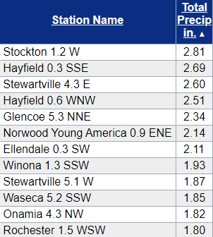
As expected, the northern edge of Minnesota missed most of it, but much of the rest of the state saw one-half inch or more, with numerous reports of more than 1 inch.
Here are some of the highest reports, most of which came from southern Minnesota thanks to heavy downpours in thunderstorms:
Some of those same storms also produced high winds, hail and localized flooding before crossing into Wisconsin.
North-central Minnesota had persistent rain much of Tuesday that also led to a nice corridor of rain totals over an inch in towns such as Detroit Lakes and Brainerd.
Wednesday’s forecast
The rain associated with that storm moved out through the overnight. As of Wednesday morning, there are just a few lingering showers in the southeastern corner of the state that continue to clear through the morning.
Turn Up Your Support
MPR News helps you turn down the noise and build shared understanding. Turn up your support for this public resource and keep trusted journalism accessible to all.
Almost all of Minnesota started Wednesday in the 50s, with a few 60s southeast, where the rain lingered, and a couple chilly 40s in the Arrowhead.
Northern Minnesota already saw some of that cooler air Tuesday, but for southern Minnesota, these Wednesday morning temperatures were a 10- to 20-degree drop in many spots versus Tuesday morning.
Highs also stay below average, in the lower 70s for the majority of the state.
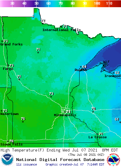
Dew points are also much lower, meaning less humidity. Skies clear through the day, with more sunshine into the afternoon.
The recent moisture and cool overnight temperatures Wednesday night may lead to fog developing, particularly in the Arrowhead and southeastern Minnesota.
Extended forecast
Thursday starts off even cooler, with a few more 50s in northern Minnesota. Highs however, nudge a couple degrees warmer, although still in the 70s.
A few spotty showers will also start moving into western Minnesota Thursday. Clouds increase across all of the state during the day.
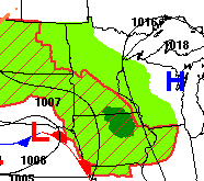
That light precipitation is ahead of a storm that currently looks like it will bring the brunt of its heavier rain and severe weather south of the state on Friday, but it should bring some scattered showers and storms through much of the state, with accumulating rain more likely the farther south you get.
There will also be enough instability on Saturday for a few more spotty showers and maybe a couple storms in southern Minnesota.
This pattern keeps more sunshine north, and northern Minnesota may start seeing a few 80s again by Friday, with more of the state getting near 80 by Saturday.
Here is that Twin Cities forecast through Saturday:
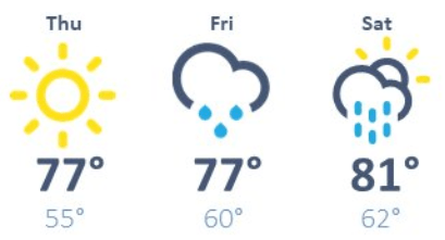
Temperatures swing back above average next week, and there could be a few 90s possible for parts of southern or western Minnesota by the middle of the week.
Programming note
You can hear my live weather updates on Minnesota Public Radio at 7:49 a.m. Monday through Friday morning.

