
Saturday rain favors southern Minn.; bright on Sunday
A look back at the record July warmth of 1936
Go Deeper.
Create an account or log in to save stories.
Like this?
Thanks for liking this story! We have added it to a list of your favorite stories.


Northern Minnesota will see fewer clouds than southern Minnesota this Saturday, but sunshine in northern Minnesota will be filtered through smoke from Canadian wildfires in several areas.
Air quality alert
The Minnesota Pollution Control agency has issued an air quality alert for northeastern Minnesota and parts of north-central Minnesota from Saturday morning to 6 a.m. Monday:

Here are details of the alert (shaded orange in the map above) from the MPCA:
Turn Up Your Support
MPR News helps you turn down the noise and build shared understanding. Turn up your support for this public resource and keep trusted journalism accessible to all.
The Minnesota Pollution Control Agency (MPCA) has issued an air quality alert for northeast Minnesota, effective Saturday, July 10, beginning at 6 a.m. through Monday, July 12, at 6 a.m. The affected area includes Duluth, Ely, Hibbing, International Falls, Two Harbors, Grand Marais, and Grand Portage, and the tribal areas of Fond du Lac, Grand Portage, Leech Lake, Mille Lacs, and Red Lake.
Smoke from wildfires located north of the Canadian border in Ontario and Manitoba will be transported by northerly winds circulating around high pressure into the northeast part of the state. Heavy smoke is expected to arrive Saturday morning and remain over the area into Monday morning. During this time, fine particle levels are expected to be in the Orange AQI category, a level that is considered unhealthy for sensitive groups. The lake breeze along Lake Superior will help bring heavier smoke down towards the surface, then the smoke will tend to drift westward towards north central Minnesota. On Monday, winds will turn out of the south and steer the smoke northward into Canada.
People whose health is affected by unhealthy air quality
There are people who are more likely to be affected when fine particle pollution reaches an unhealthy level.
People who have asthma or other breathing conditions like chronic obstructive pulmonary disease (COPD).
People who have heart disease or high blood pressure.
Children and older adults.
People of all ages who are doing extended or heavy, physical activity like playing sports or working outdoors.
Health effects
Air pollution can aggravate heart and cardiovascular disease as well as lung diseases like asthma and COPD. When the air quality is unhealthy, people with these conditions may experience symptoms like chest pain, shortness of breath, wheezing, coughing, or fatigue. If you are experiencing any of these symptoms, use your inhalers as directed and contact your health care provider.
Take precautions
Everyone should take precautions when the air quality is unhealthy.
Take it easy and listen to your body.
Limit, change, or postpone your physical activity.
If possible, stay away from local sources of air pollution like busy roads and wood fires.
If you have asthma, or other breathing conditions like COPD, make sure you have your relief/rescue inhaler with you.
People with asthma should review and follow guidance in their written asthma action plan. Make an appointment to see your health provider if you don’t have an asthma action plan.
Saturday rain chances
Portions of southwestern Minnesota and south-central Minnesota will continue to see some periods of rain this Saturday, with a thunderstorm also possible. Southeastern Minnesota could see a few scattered showers and an isolated thunderstorm. A brief shower is possible in the Twin Cities metro area, but most of the metro area is expected to have a dry Saturday.
Temperature trends
Northwestern Minnesota and north-central Minnesota have the best chance of reaching the 80s Saturday afternoon. Mainly 70s are expected elsewhere in Minnesota.
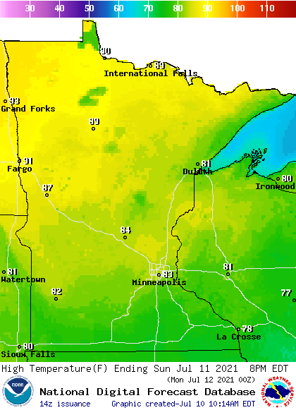
Sunday highs reach the 80s in most spots:
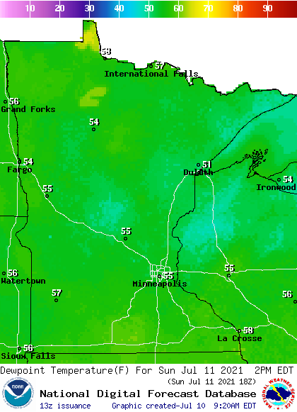
Sunday dew points will be mainly in the comfortable 50s:
Back to high temps, Twin Cities metro area highs are projected to reach the lower 80s Monday, followed by upper 80s Tuesday and upper 70s on Wednesday. Highs rebound to the mid 80s for Thursday and Friday.
1936 heat
Our Twin Cities record high temp for July 10 is 106 degrees, set in 1936. That was the start of an incredibly hot five day stretch. July 1936 highs are on the left and lows on the right in the following chart:
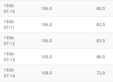
The official Twin Cities high temp was 106 degrees on July 10,11 and 12 of 1936, followed by 105 on July 13 and 108 on July 14. Low temps were in the 80s on four of those five days. Home-air-conditioning didn’t exist during that heat wave. July 1936 is still the warmest month in Twin Cities weather records.
Programming note
You can hear my live weather updates on MPR News at 7:35 a.m., 9:35 a.m. and 4:39 p.m. each Saturday and Sunday.

