
A summery Monday; welcome rain on Wednesday
Hot weather returns next weekend
Go Deeper.
Create an account or log in to save stories.
Like this?
Thanks for liking this story! We have added it to a list of your favorite stories.


The Sunday high temp at Minneapolis-St. Paul International Airport was 87 degrees. Our average Twin Cities high is 84 degrees this time of year. Dew points were in the comfortable 50s in the metro area and across most of Minnesota.
Smoke update
Satellite shows smoke from Canadian wildfires over much of Minnesota and parts of western Wisconsin. Much of the smoke is aloft, but a portion of the smoke has spread to ground level in some areas. The Minnesota Pollution Control Agency has cancelled the air quality alert that had been in effect this weekend in northeastern Minnesota. Our sunset tonight and sunrise tomorrow will be colorful in areas that have Canadian wildfire smoke in the air.
Temperature trends
Turn Up Your Support
MPR News helps you turn down the noise and build shared understanding. Turn up your support for this public resource and keep trusted journalism accessible to all.
Monday highs will be in the 80s in most areas:
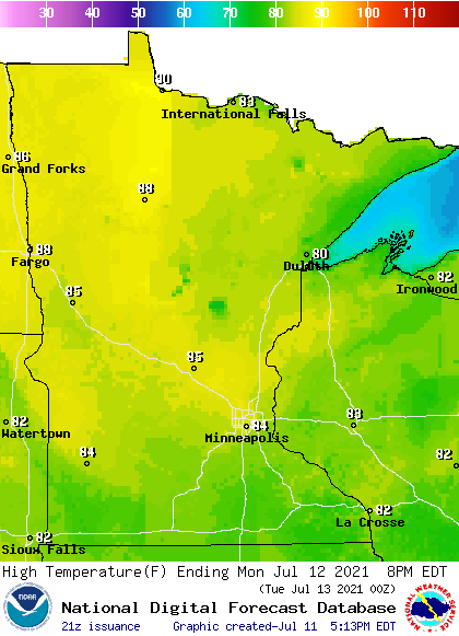
There will be a few 70s up along the North Shore of Lake Superior.
Dew points will be in the comfortable 50s:

Back to forecast high temps, Twin Cities metro area highs are projected to reach the upper 80s on Tuesday, followed by upper 70s Wednesday. Highs rebound to the lower 80s Thursday and mid 80s on Friday.
We could see highs around 90 degrees next weekend, and temps may be a bit above average the following week. The Climate Prediction Center of the National Weather Service shows a tendency for above normal temps in Minnesota and Wisconsin from July 19 through July 25:

Wednesday soaker?
Some forecast models give us meaningful rain Wednesday into Wednesday night. NOAA’s Global Forecast System (GFS) model shows the potential rain pattern for Wednesday and Wednesday evening:

Check forecast updates as we get closer to Wednesday.
You can hear updated weather information for Minnesota and western Wisconsin on the Minnesota Public Radio network, and you can see updated weather info on the MPR News live weather blog.
Less daylight
Here in the Twin Cities, we’ve lost about 15 minutes of daylight since the summer solstice in June. Our sunset is at 8:59 p.m. today…it doesn’t set before 8 p.m. until August 27.
Programming note
You can hear my live weather updates on MPR News at 7:35

