
Heat builds across Minnesota as conditions stay dry
Air quality issues remain a concern, especially for the northern edge of the state
Go Deeper.
Create an account or log in to save stories.
Like this?
Thanks for liking this story! We have added it to a list of your favorite stories.


Minnesota sees another warm, dry, and hazy day Friday, which is the beginning of a much drier pattern that is likely to last all of next week and possibly through the end of July.
Friday’s forecast

Under the influence of high pressure just to the east of Minnesota, the state started Friday with light winds and clear skies. Morning lows were seasonable in the 50s and 60s, with a couple of 40s in the Arrowhead.
There are still issues with smoke from the fires in Canada, and parts of Minnesota along the North Dakota and Canadian borders are under an air quality alert through at least noon Saturday.
The flow around the high pressure brings a more southerly flow across Minnesota during the day, which should lessen the amount of surface-level smoke coming in for other parts of Minnesota. However, most of the state does stay hazy through the day due to the smoke in the upper atmosphere.
Those southerly winds turn gusty for northwestern Minnesota by the afternoon, making that our warmest part of the state Friday with temperatures near 90.
Turn Up Your Support
MPR News helps you turn down the noise and build shared understanding. Turn up your support for this public resource and keep trusted journalism accessible to all.

The rest of the state stays in the mid and lower 80s under plentiful sunshine.
Weekend forecast
Northwestern Minnesota remains the warm spot over the weekend, with 90s becoming more likely, while the rest of the state also keeps warming into the upper 80s.
Conditions remain dry, and although it will be sunny, hazy conditions are forecast to continue through at least Saturday.
Here is the forecast for the Twin Cities through Monday:

Extended outlook
A broad ridge of higher pressure is building over the northern plains, bringing hot and dry weather to the region. This will keep Minnesota hot as well, with most of the state seeing highs in the 90s all week (the Arrowhead will be slightly cooler).
With the core of the heat expected to sit over the Dakotas, western Minnesota especially could see 100s by the end of next week. The pattern also brings almost no chances for rain over the next seven days.

Our outlook through the end of July additionally shows the likelihood that hotter and drier-than-average weather persists through the end of the month.
So far this year, most of Minnesota is ranging from 2 inches to more than 8 inches below normal rainfall, and the heat dries our vegetation out even faster.
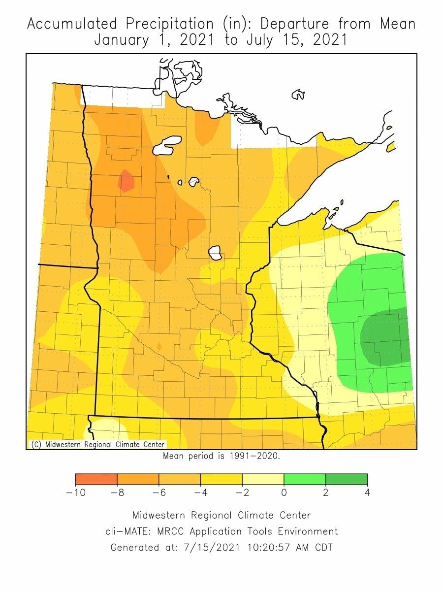
The upcoming weather will continue to intensify the drought conditions over 98 percent of the state is already under.
Programming note
You can hear my live weather updates on Minnesota Public Radio at 7:48 a.m. Monday through Friday morning.

